
I started this project back in 2016 with a simple goal: to publish tourist maps that contain all the essential information needed to plan a trip.
Travel has always been my passion, along with photography and geography. Combine all three, and you’ll understand the inspiration behind this project. It felt like the perfect way to bring my passions together in one place: a website. It sounded exciting, so I followed my instincts. In fact, those instincts were born years ago, when, as a child, I used to read the Garzanti Geography Encyclopedia during my “daily journeys,” sitting on the toilet.
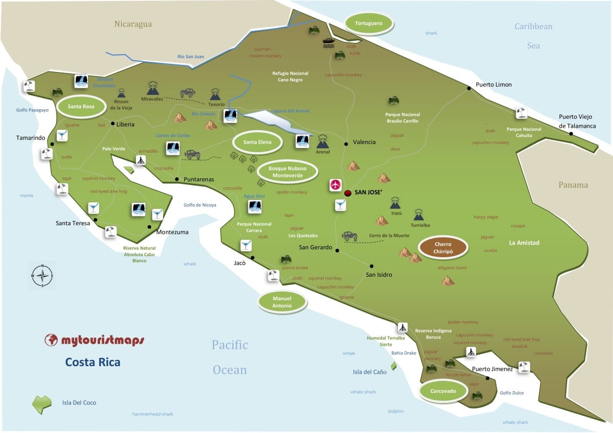
As I grew older, I started travelling (**special thanks to my family and my travel buddies). After reading books and guidebooks, I began sketching handmade maps on paper to help me remember the attractions and places I didn’t want to miss. My very first map was for Costa Rica – an unforgettable trip.
Later, I also developed a love for photography. If you love travelling, photography comes naturally. My first camera was a Minolta X-300 film camera, which (along with Pasquale Laricchia) taught me the basics of photography. I’ve never been a professional photographer, but I still love it, and now and then some of my pictures appear in the content on this site.
Over time, I started searching online for easy-to-read tourist maps that would show the main attractions, animals (I love animals), and other useful info. But I couldn’t find what I was looking for. That’s when I thought: what if I created a site that combined all of my passions – maps, travel, photography, and research – into something that didn’t really exist yet? And to be honest, turning this into a real job would have been a dream come true. I’m not there yet, but I’m still trying.
In the meantime, I hope my maps and content can help and inspire people to discover new places and plan their trips. Some people say I’m a paranoid travel planner. Maybe. But I believe that knowing where you’re going is crucial. I realised this the hard way, when I visited Yellowstone National Park and didn’t know about the Grand Prismatic Spring – we missed it completely. I’ll never forgive myself (and Gini, Johnny, Pica) for that. But one day, I’ll go back.
Even today, it’s still hard to find clear, readable tourist maps that don’t force you to jump between dozens of websites, travel guides, and other tools just to plan a trip.
Since the beginning, I’ve never stopped creating maps and content, trying to improve both the quality and usefulness of what I produce. It’s not easy without a professional team – but pole pole (slowly, slowly), I’m learning, and I think I’m getting better.
The purpose of these maps is to put everything you need to plan your trip into a single, easy-to-read visual tool. No zooming, no searching – just click and open photos, info, booking links, etc. I’ve chosen to link most content to Google Images, because that’s what I use when I plan my trips – I need to see what’s there. Then I look for more info, but images come first. It might not sound very professional, but who cares? It’s practical. And that’s what my maps need to be: practical, useful, and helpful.
I create every map manually, based on research and, in some cases, my own experience in the field. No, I haven’t (YET) visited all the places you’ll find here, but I’ll do my best… There’s so much to discover on this planet: nature, people, traditions, culture. And yes, it’s true: travel really does open your mind. It’s a cliché – but a very real one.

Contact us (me) at info@mytouristmaps.com
podcast – from Garzanti to mTm