
Thirty kilometres west of Toledo, the flat, wheat-coloured plains of Castilla-La Mancha stop suddenly at the edge of a cliff. Below, the land falls away in red and ochre walls of clay, cut into ridges and spires, and at the bottom lies the still, blue-green water of the Castrejón reservoir. Spanish newspapers like to call it the Grand Canyon of Toledo. That is an exaggeration in scale, but people who stand at the edge for the first time usually see the point.
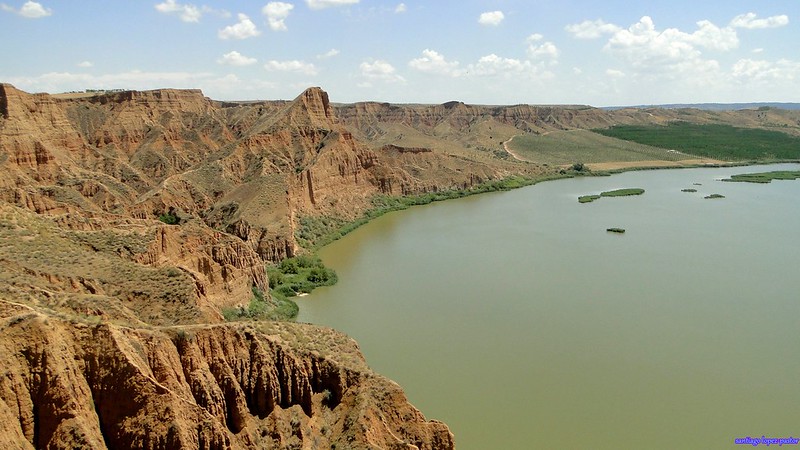
The official name is the Barrancas de Castrejón y Calaña, but almost everyone calls them the Barrancas de Burujón, after the small village of around a thousand people nearby. The cliffs actually spread across three municipalities, Burujón, Albarreal de Tajo and La Puebla de Montalbán, along the northern shore of the reservoir on the Tagus, the longest river in the Iberian Peninsula.
How the Barrancas Were Carved
The barrancas are badlands, or cárcavas in Spanish. They formed in soft sediments laid down more than 25 million years ago. Over time, wind, rain and especially the Tagus wore these layers away. Clay is soft and easily eroded, so the river did not cut a single clean gorge. It left a ragged half-moon of gullies, knife-edge ridges and pinnacles about a kilometre long. The colours come from the different layers of clay and rock, and they shift from rust to cream to almost pink as the light moves across them.
The highest point is the Pico del Cambrón, where the drop to the water is more than 100 metres. The water itself is a recent addition. The Castrejón dam opened in 1967, and its reservoir now fills the base of the cliffs. Before the dam, the river ran directly beneath them. Today the reflection of red walls in calm water, with two small green islets in the middle, is what makes the place so photogenic.
That look has drawn more than hikers. The cliffs have appeared in TV series, documentaries and advertising, most famously a Coca-Cola commercial filmed here in 2013. They have stood in for the American West more than once.
In 2010 the regional government declared the site a Monumento Natural. It is also a Special Protection Area for Birds and part of the European Natura 2000 network. Raptors nest in the cliff faces, and the reservoir attracts ducks, waders and other waterbirds, so binoculars are worth packing. More information about the protected area is available from the Castilla-La Mancha Protected Areas network.
Walking the Barrancas de Burujón
The main route is the Senda Ecológica de las Barrancas, a signposted circuit of roughly 4.5 kilometres along dirt tracks. It gains only about 120 metres of elevation, so most visitors finish it in around two hours, including stops at the viewpoints. Walks usually start near the Bar El Refugio de las Barrancas. From there the Vereda de las Barrancas follows the rim towards the main lookouts: the Mirador del Cambrón, the most dramatic, and the Mirador de los Enebros, which has free parking beside it. From the Enebros viewpoint, a side path drops down to the shore of the reservoir.
Those short on time can drive straight to the viewpoint car parks and see the best of it in half an hour. Access is free and there are no tickets or opening hours. The clay edges are unstable, though, and there are few barriers, so it is safest to stay well back from the drop, especially after rain.
Spring and autumn are the best seasons. The fields around the canyon turn green in April and May, and temperatures are mild enough for walking at midday. Summers in the Tagus valley are fiercely hot and there is almost no shade on the rim, so anyone visiting in July or August should come early or late. In any season, sunset is the moment to be there, when the low light sets the cliffs glowing deep orange.
Getting There and Staying Connected
The barrancas lie about 30 kilometres west of Toledo and roughly 100 kilometres from Madrid, which makes them an easy half-day trip from either city. There is no direct public transport, so a car is essential. From Toledo, the CM-4000 heads west towards La Puebla de Montalbán. Shortly before the turn-off for Burujón, a dirt track on the left leads to the car parks. For the wider region, the Spain interactive map on mytouristmaps pins the barrancas alongside other stops in central Spain.
Unsigned dirt tracks, a car park in the middle of the fields and a sunset worth sharing all make reliable mobile data useful on this trip, even though the barrancas are only half an hour from Toledo. A Holafly eSIM with unlimited data takes care of that for travellers coming from abroad. They can navigate the tracks, check the sunset time and upload photos straight from the rim without counting megabytes or paying roaming charges. The eSIM installs before departure and starts working on arrival in Spain.
Holafly’s Always On feature covers the gaps. It is included with Holafly eSIMs and switches on automatically, providing 1GB of backup data every month in supported destinations as long as the eSIM stays installed. That backup is there for a long layover on the way home, an extra day added on the spot, or the moment a plan runs out just as a booking needs confirming.
Anyone planning a trip to Toledo, the barrancas or anywhere else can get connected before leaving with Holafly’s unlimited data eSIMs, using the code MYTOURISTMAPS for a discount at checkout. Follow @holafly for more travel connectivity tips and share the journey with #HolaflyTraveller.
After the walk, the village of La Puebla de Montalbán is a short drive away. It is the birthplace of Fernando de Rojas, author of La Celestina, and has a small museum dedicated to the book. It makes a quiet end to the day, though most visitors find themselves driving back to the rim for one last look as the cliffs turn red.