Mada’in Saleh, Saudi Arabia

Mada'in Saleh, Saudi Arabia
Qaṣr Al-Farīd tomb photo © Ahmad AlHasanat
 

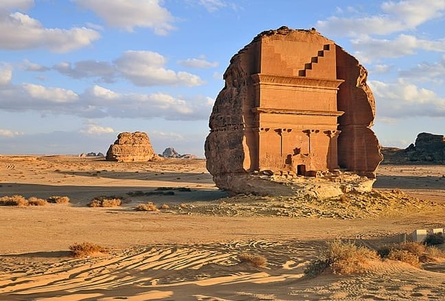
Also known as Al-Ḥijr or Hegra, this impressive archaeological site belonged in the first century AD to the kingdom of Nabatean, a nomadic Bedouin tribe of the northern Arabian peninsula, whose capital was Raqmu, now known as the famous Petra (Jordan).

According to the Quran, it is believed that this is a cursed place, owing to the punishment with natural disasters given from Allah to the Thamud people (8th century BCE) for their idol worshipping.

The outstanding location consists of 131 rock-cut monumental tombs and was the first Arabian proclaimed UNESCO World Heritage Site in 2008.

The site is reachable by car from the nearest towns with flight connections: al-Wajh (100 km) and al-Ula (20 km).

All visitors need a permit to visit Mada’in Saleh (you can easily obtain the permission in the Hotels near the site).

Northern Ireland’s Peace Walls, U.K.

Belfast Peace Walls
Peace Wall in Cupar Way, Belfast, photo © mytouristmaps
 

Some of the Northern Ireland‘s neighborhoods are still divided by walls: the Peace Walls (or Peace Lines) separate the nationalists/Catholics/Irish from the loyalists/Protestants/British people.

Most of them are in Belfast, others are also existing in Portadown, Derry and Lurgan, with a total length of around 34 km; some of them have gates that are opened only during daylight.

The walls were initially built as a temporary structure to avoid the violence episodes; the first peace line is dating back to 1969 in Belfast after the riot that had involved nationalists, loyalists and police that caused more than 150 homes destroyed, almost two thousand families evacuated, 8 killed and more than 700 injured people.

The number of the walls have raised from less than 20 in the early 1990s to more than one hundred nowadays; there was also an increase after the Irish-British Good Friday Agreement of the 10th April 1998.

According to the public local opinion, the walls are still necessary to maintain the peace and avoid the violence in those areas: the majority of the people still think that more time is needed to change the mentality that has caused lots of conflicts in the past.

In September 2017, the Northern Ireland Department of Justice published its Interface Programme, which intention is removing all the structures by 2023.

Reading the messages of thousands of people marked on the Peace Walls, it is evident that the thought of the people, with or without walls, is still aimed at peace.

Lough Tay, Ireland

Lough Tay, Ireland
photo © mytouristmaps
 

The Lough Tay, located in the Wicklow Mountains, about 50 km south from Dublin, is also known as the Guinness Lake due to its shape and colours.

The white sandy beach on the northern coast makes the Guinness foam. The brown colour of the water close to the beach (due to the water coming from the streams that rise on peat covered uplands) complete the incredible visual similarity to the famous Irish pint.

You can see the lake from the R759 scenic route, or if you want a better view from the top, take the walking trail towards the Luggala mountain (accessible from the R115 — the best scenic drive in the Wicklow mountains) or the Djouce mountain, one of the most spectacular walks in the Wicklow Mountains, from which you can see the whole Dublin bay and, on a clear sky day, also the Welsh coastline.

The Lough Tay beach was chosen in 2013 as the set for the village of Kattegat in the Vikings tv series.

Impact Craters on Earth

Impact craters on earth are difficult to preserve due to the continuous remodeling of the earth’s crust by orogenesis, plate tectonics and atmospheric agents.

There are around 180 recognizable impact craters on earth, of which about 60 are now buried under sediments, a considerably lower number, for example, compared to the 360.000 craters on Mars or the 7.000 on the moon.
This thanks to the shield made by the earth’s dense atmosphere.
Some of them have caused catastrophes, such as the meteorite that carved the Chicxulub crater in Mexico: according to the theory currently accepted by the scientific community postulated by the physicist Luis Álvarez and his son geologist Walter Álvarez, is widely thought to have caused 65 million years ago the end of the dinosaurs due to a tsunami and dust emissions which totally covered the earth’s surface a cloud of dust for many years.

Others have instead brought wealth as the Popigai crater in Russia, whose impact transformed graphite into diamonds within about 13 km radius.

List of the biggest impact craters on earth:

1. Vredefort Dome, South Africa: 160 km diameter, 2.02 billion years old.
2. Chicxulub crater, Mexico: 150 km diameter, 65 million years old.
3. Sudbury crater, Canada: 130 km diameter, 1.85 billion years old.
4. Popigai crater, Russia: 100 km diameter, 35 million years old.
5. Manicouagan crater, Canada: 100 km diameter, 214 million years old.
6. Acraman crater, Australia: 90 km diameter, 580 million years old.
7. Chesapeake Bay crater, USA: 85 km diameter, 35 million years old.
8. Morokweng crater, South Africa: 70 km diameter, 145 million years old.
9. Kara crater, Russia: 65 km diameter, 70 million years old.
10. Beaverhead crater, USA: 60 km diameter, 600 million years old.

Wikimedia map link

Well preserved impact craters on earth:

Aouelloul crater, Mauritania
3,1 million years old, 390 m diameter, 53 m depth.

Aouellol Crater
Aouelloul crater © Digital Globe – Google Earth

Tenoumer crater, Mauritania
30.000 years old, 1,9 km diameter, 100 m depth.

Tenoumer crater
Tenoumer crater © NASA


The Roter Kamm crater, Namibia
5 million years old, 2,5 km diameter, 130 m depth.

Roter Kamm Crater
The Roter Kamm crater © NASA


Lonar crater lake, India
50.000 years old, 1,2 km diameter, 137 m depth.

Lonar lake
Lonar crater lake © Wikimedia Commons


Monturaqui crater, Chile
One million years old, 460 m diameter, 34 m depth.

Monturaqui crater
Monturaqui crater © Wikimedia Commons


Gosses Bluff crater, Australia
142 million years old, 6 km diameter, 180 m depth.

Gosses Bluff crater
Gosses Bluff crater © Wikimedia Commons


Pingualuit crater, Canada
1,4 million years old, 3,44 km diameter, 270 m depth

Pingualuit crater
Pingualuit crater © NASA


Amguid crater, Algeria
100.000 years old, 450 m diameter, 30 m depth

Amguid crater
Amguid crater © Wikimedia Commons


Wolfe Creek crater, Australia
300.000 years old, 875 m diameter, 25 m depth

Wolfe Creek crater
Wolfe Creek crater © NASA


Barringer crater, USA
40.000 years old, 1,2 km diameter, 170 m depth.

Barringer crater
Barringer crater © James St. John


The Rock of Guatapé, Colombia

Also known as Stone of Peñol (since this rock formation is claimed by both the bordering towns of Peñol and Guatapé) the Rock of Guatapé is a granitic monolith located in the Peñol – Guatapé reservoir, about 40 km East of Medellìn, Colombia.

The rock is 200 meters high and it is surrounded by a magnificent lagoon, which is formed by the hydro-electric dam, built in the 1960-70s.

Visitors can reach the top of the rock climbing up the 650 steps on the stairway, enjoy the stunning view and visit two Benedictine monasteries.

Loktak Lake, India


Also known as the Floating Lake, the Loktak Lake, located in Bishnupur district of Manipur, about 50 km south of the city of Imphal, is the largest freshwater lake in North-Eastern India.

With a surface of 290 square kilometres, it is famous and unique for its floating islands named phumdis: masses of soil, organic matter and vegetation that hosts several species of animals and aquatic plants including the Sangai, a brow-antlered deer, state animal of Manipur.

Part of the lake houses the Keibul Lamjao National Park, the world’s only floating national park.

Playa Roja, Perù

Located in the Paracas National Reserve, in the region of Ica, Peru, between Punta Santa Maria and Playa Lagunillas, the Playa Roja is a stunning beach where the pink granodiorite rocks form a unique landscape with red sandy beach and cliffs.

To reach Playa Roja, follow the trail leading to the entrance of the Paracas Reserve. After passing by the museum, also known as the “Centro de Interpretación,” proceed in the direction of Lagunillas. Upon reaching the Lagunillas checkpoint, continue until you arrive at Playa Roja.