
Rising straight out of the Atlantic, the island of Fogo is essentially a single volcano. Its name means “fire” in Portuguese, and it has earned it. At the top of the island, inside a vast collapsed crater, lies one of the strangest inhabited landscapes in Africa: the Pico do Fogo lava fields, a plain of black, twisted rock where people still grow grapes, make wine and rebuild their homes on top of the flows that destroyed the previous ones.
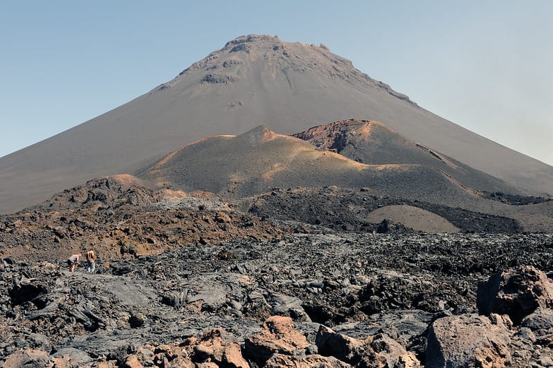
The crater floor is called Chã das Caldeiras, the “plain of the calderas”, and it sits at roughly 1,700 metres, making it the highest settlement in Cape Verde. On one side it is enclosed by the Bordeira, a curving cliff wall up to a kilometre high. In the middle stands the cone of Pico do Fogo itself, 2,829 metres tall, the highest point of the country. Everything in between is lava: some of it centuries old and softened by ash and vines, some of it barely ten years old and still sharp enough to cut a pair of boots.
A crater that keeps refilling
The caldera formed when the summit of an older, larger volcano collapsed, possibly sliding into the sea on the eastern side of the island. The new cone of Pico do Fogo then grew inside the hollow, and every eruption since has poured fresh lava across the crater floor, where it pools against the Bordeira. The result is a patchwork of flows of different ages and textures: smooth, ropy pahoehoe in some places, jagged clinker-like aa in others, cinder cones, fissures and small craters scattered across a plain of roughly 67 square kilometres, all protected as part of the Parque Natural do Fogo.
Since settlers moved into the crater in the 19th century, three eruptions have reshaped it: in 1951, 1995 and 2014–2015. The 1995 event built a new side vent, known as Pico Pequeno, at the foot of the main cone. The most recent eruption began on 23 November 2014 and lasted until 8 February 2015. Its fast-moving flows buried about three quarters of the buildings in the villages of Portela and Bangaeira and the small hamlet of Ilhéu de Losna, along with the wine cooperative, the brand-new park headquarters, farmland and the only road into the crater. Roughly a thousand people were evacuated.
What makes the place remarkable is what happened next. The government offered housing elsewhere on the island, but the crater was where these families had their fields, and many came back. Today new houses stand directly on the 2014 lava, the road has been cut through the flows again, and walking between the buildings you can still see roofs and walls poking out of the black rock like the remains of a shipwreck.
Wine, apples and a French count
It seems impossible that anything could grow here, yet the volcanic ash holds moisture from the mist that drifts over the Bordeira, and the crater has long been one of the most productive farming areas of Fogo. Vines are planted in shallow pits dug into the ash, each protected by a low ring of stones. Beans, maize, quince, pomegranates and apples grow alongside them. The local wine, sold simply as Vinho do Fogo or under the name of the rebuilt cooperative, is red, white or sweet passito-style, and tasting it inside the crater is part of the experience.
The people of Chã das Caldeiras are also a curiosity in themselves. A surprising number have fair hair and light eyes, and many trace their family tree back to a 19th-century French nobleman, the Count of Montrond, who settled on the island, introduced vines and fathered an impressive number of children. The surname and the features have been handed down ever since.
Climbing the volcano
Most visitors spend at least one night in the crater, in one of the small guesthouses that have reopened since the eruption, and set off before dawn to climb Pico do Fogo. The ascent is steep, loose and unshaded, climbing more than 1,100 metres from the crater floor, and usually takes three to four hours with a local guide, which is strongly recommended. From the rim the view drops into the summit crater, still steaming in places, and on clear days reaches the neighbouring island of Brava. The descent is the fun part: a long, fast run straight down a slope of fine black scree, done in a fraction of the time it took to go up.
Shorter options include the walk to Pico Pequeno and the 2014 vents, where the lava still shows its shape as it flowed, or a hike along the Bordeira rim for a full view of the caldera from above.
When to go and how to get there
The drier months from November to June are the best time for hiking, with clearer skies and cooler mornings; between December and February the harmattan wind can bring Saharan dust and a hazy horizon. The short rainy season, roughly August to October, turns the lower slopes green but makes trails and roads less predictable. At 1,700 metres nights can be cold at any time of year, so a warm layer is essential.
Fogo is reached by domestic flight or ferry from Praia, on the island of Santiago, to the colourful colonial town of São Filipe. From there, shared minibuses known as aluguers or private taxis climb to the crater in about an hour and a half, the road winding up through small villages before cresting the Bordeira and dropping suddenly into the black plain. For travellers exploring the wider volcanic world of Macaronesia, the same fiery geology shapes the Canary Islands and the Azores, but nowhere else do people live quite so literally inside the volcano.
Arrive in late afternoon, when the low sun turns the lava from black to deep bronze and the peak throws its shadow across the crater, and it becomes clear why the families of Chã das Caldeiras keep coming back.