Castelmezzano, Italy

Hidden among the dramatic rock formations of the Lucanian Dolomites, less famous than the cousin Dolomites in the Alps, yet still spectacular, Castelmezzano and Pietrapertosa are two of the most fascinating mountain villages in Italy. Built directly onto steep slopes and surrounded by sandstone peaks, the two villages appear almost suspended above the valleys below.

Their extraordinary setting is the main reason to visit, but the area offers much more than beautiful scenery. Narrow stone streets, ancient churches, mountain trails and traditional Lucanian food make the two villages particularly rewarding for travellers interested in discovering a less-visited side of Italy.

The most famous attraction, however, is the Volo dell’Angelo, or Angel Flight, an extraordinary zipline connecting Castelmezzano and Pietrapertosa. Suspended hundreds of metres above the valley, visitors can literally fly between the two villages at speeds of up to 120 km/h.

Castelmezzano and Pietrapertosa are located in the province of Potenza, in the mountainous interior of Basilicata.

The two villages are only a few kilometres apart as the crow flies, but the surrounding mountains make the landscape appear much more dramatic. Both settlements were built in naturally protected positions among the rocks, and their historic centres still retain much of their traditional character.

Castelmezzano

Castelmezzano is perhaps the more immediately recognisable of the two villages. Its houses seem to climb up the mountainside, with narrow alleys and stairways winding between buildings and enormous rocky formations.

The village is particularly attractive when explored on foot. Instead of looking for one single major monument, the best experience is to wander through the historic centre, where the streets repeatedly open onto views of the surrounding mountain range.

Among the principal sights is the Church of Santa Maria dell’Olmo, the village’s main church. The remains of the old Norman-Swabian castle are another reminder of the strategic importance of the settlement in the past.

One of the area’s most interesting walks is the Percorso delle Sette Pietre, or Path of the Seven Stones. The route connects Castelmezzano with the surrounding mountain landscape and is inspired by stories and traditions of the local area.

For visitors who enjoy hiking, this is a particularly good way to experience the unusual rock formations from ground level rather than simply admiring them from the village.
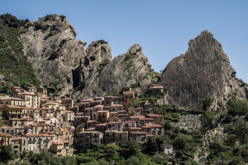
Castelmezzano
photo © mytouristmaps – Castelmezzano

Another exciting attraction in Castelmezzano is the Slittovia delle Dolomiti Lucane, a mountain coaster that opened in 2025. The 1,180-metre track descends through the spectacular sandstone peaks of the Dolomiti Lucane, with speeds of up to 40 km/h and a maximum gradient of 65%. The ride connects the mountain of Paschiere directly with the village and can be enjoyed individually or in pairs. For opening times, prices and practical information, visit the official Slittovia website.

Pietrapertosa

Located at an altitude of around 1,000 metres, Pietrapertosa is the highest municipality in Basilicata and is dramatically positioned among the rocks of the Dolomiti Lucane.

The village has a distinctly mountainous character, with stone houses, steep lanes and stairways following the contours of the rock. The most spectacular part of the historic centre is around the remains of the ancient Saracen Castle, perched high above the settlement.

From the higher viewpoints, the surrounding landscape stretches across the mountains and valleys of Basilicata.

Pietrapertosa is also the starting point for the Via Ferrata Marcirosa, an adventurous route through the rocky landscape. Together with the trails around Castelmezzano, it makes the area an excellent destination for hiking and outdoor activities.
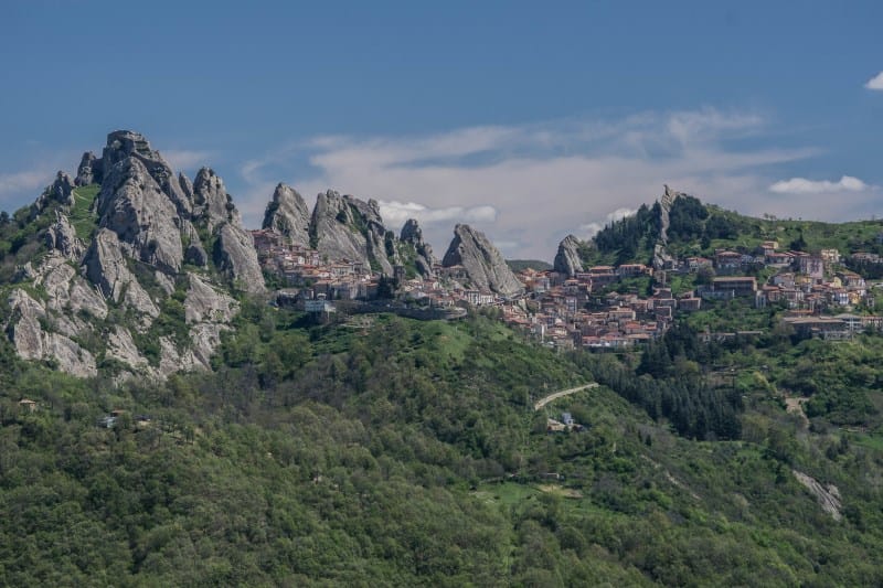
Pietrapertosa
photo © mytouristmaps – Pietrapertosa

The Volo dell’Angelo: flying between two villages

The Volo dell’Angelo is the attraction that has put Castelmezzano and Pietrapertosa on the international travel map.

Instead of simply travelling between the two villages by road, visitors can attach themselves to a steel cable and fly across the valley.

There are two different flight lines. The Peschiere line begins at Castelmezzano, at approximately 1,019 metres, and travels towards Pietrapertosa, covering about 1,452 metres and reaching a maximum speed of approximately 120 km/h.

The return route, known as the San Martino line, starts from Pietrapertosa at approximately 1,020 metres and travels towards Castelmezzano. It is around 1,415 metres long and can reach approximately 110 km/h.

The experience is not simply a short zipline ride. The real attraction is the scenery. For several minutes, you are suspended high above the valley with the jagged peaks of the Lucanian Dolomites surrounding you.

The ticket includes the flights in both directions on the two different lines, as well as the necessary transfer between the villages.

The Volo dell’Angelo is operated with a safety harness attached to the steel cable, but it is still an adventure activity in a mountainous environment.

Weather is particularly important. The official operator warns that sudden summer storms can occur because the activity takes place outdoors in the mountains. Visitors should therefore check the weather conditions before travelling.

There are also restrictions concerning clothing and luggage. For example, the operator specifies that participants must wear a T-shirt rather than a vest, while only small personal bags are permitted during the flight.

It is worth checking the official website before travelling because operating days and conditions can vary during the year.

Official Volo dell’Angelo website

Best time to visit Castelmezzano and Pietrapertosa

The best months to visit are generally May, June, September and October. Temperatures are usually more comfortable for walking and hiking than during the hottest part of summer, while the surrounding mountains can look particularly beautiful in spring and autumn.

July and August are ideal if you want to experience the villages during their liveliest period and have the best chance of enjoying the outdoor attractions, but temperatures can be high and the area can be considerably busier.

If your main reason for visiting is the Volo dell’Angelo, check the operating calendar before planning your trip. The attraction does not operate continuously throughout the year, and opening schedules vary by season.

Winter offers a completely different atmosphere. Snow can occasionally transform the villages and surrounding mountains, creating an exceptionally scenic landscape, although some outdoor activities may be unavailable.

How to get to Castelmezzano and Pietrapertosa

The villages are in a relatively remote mountainous part of Basilicata, so a car is the easiest option for exploring the area.

From Potenza, the journey to Castelmezzano takes roughly one hour by car, depending on traffic and road conditions. Pietrapertosa can be visited on the same trip because the two villages are connected by local roads.

The nearest major airports are Bari in Puglia and Naples in Campania. From either airport, renting a car is generally the most convenient option, particularly if you want to combine the villages with other destinations in Basilicata.

A visit to Castelmezzano and Pietrapertosa can also be combined with Matera, making it possible to include two very different landscapes in the same Basilicata trip: the ancient rock settlements of Matera and the spectacular mountain villages of the Dolomiti Lucane.

You can visit both villages in one day, particularly if your main objective is to experience the Volo dell’Angelo and walk through the historic centres.

However, staying one or two nights allows you to experience the area at a much slower pace and explore some of the hiking trails.

For an active itinerary, two days would be ideal: spend the first day exploring Castelmezzano and the Seven Stones Path, then visit Pietrapertosa and experience the Volo dell’Angelo on the second day.

The Two-Map Method: How to Turn Saved Google Maps Places into a Trip You Can Actually Follow

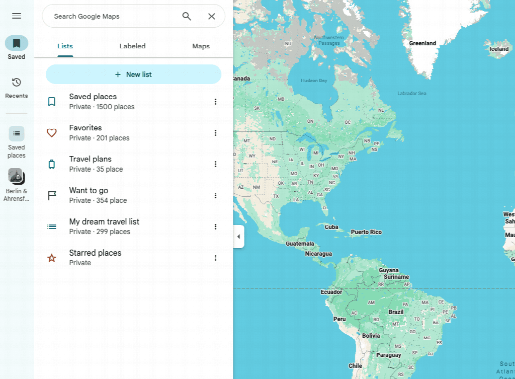
Trips tend to begin with a tap on Save in Google Maps. A café recommended by a friend goes into Saved places. A museum from a travel newsletter or a viewpoint spotted in a video joins Want to go. A few months later, those lists hold 60 or 80 pins: some for the next trip, some for a vague “someday,” and a few you no longer remember saving.

Those lists are useful for collecting ideas, but not for deciding where to go once you’re there. The problem isn’t saving too much; it’s treating a growing collection as if it were already a trip plan.

A simple fix is to use two lists inside Google Maps: an inspiration map for collecting possibilities and a trip map for the places that fit this journey. In practice, each “map” is simply a saved list; you don’t need to build a custom map from scratch. The first can be untidy. The second should be small enough to make decisions for you.

The two-map method: a large inspiration map becomes a focused trip map

One saved list collects possibilities. A second, shorter list turns them into a plan.

Map one is allowed to be messy

The inspiration map is the list where you save first and judge later. It can include places from previous research, recommendations from friends, ideas for a future visit, and spots you may never get around to seeing.

Trying to organise every new pin the moment you save it turns travel research into admin. It also encourages premature decisions. A restaurant that seems too far away today may be perfect once you know where you’re staying. A coastal walk that doesn’t fit a winter weekend might become the main reason for returning in summer.

Use broad labels if they help: food, museums, outdoors, evening, rainy day. Don’t build a timetable yet. The purpose of this map is to stop good ideas from disappearing, not to promise that you’ll visit all of them.

It helps to add one short note when the reason for saving a place isn’t obvious. “Go before 9 a.m.” is more useful than a copied paragraph from a review. So is “cash only,” “book ahead,” or “view from the terrace.” Months later, you’ll still know why the pin mattered.

A collection of saved place lists used while planning a trip

A saved list collects possibilities, but it still needs editing before it becomes an itinerary.

Map two has to earn every pin

The second list — the trip map — starts once the dates and accommodation are known. Instead of looking at all your saved places and asking, “Which ones do I like?”, ask a harder question: “Which ones fit this particular trip?”

Begin with the constraints that cannot move:

  • arrival and departure times;
  • accommodation location;
  • booked tickets or tours;
  • days when attractions are closed;
  • the pace of the people travelling with you.

Now copy only the strongest candidates into the trip map. A place should survive because it’s important to you, because it sits naturally beside another stop, or because it solves a practical need such as lunch near a museum. Fame alone isn’t a reason to keep it.

Create a new Google Maps list with the destination and dates in its name, such as “Lisbon — 14–18 March.” A place can sit in more than one list, so adding it to the trip list doesn’t remove it from your inspiration collection. Google Maps doesn’t offer a bulk-copy command, though, so a long shortlist still has to be added one place at a time.

If the original list is long, ExportMyMap can export the places from your saved lists to a spreadsheet, making it easier to filter them by country, state or region before narrowing the collection to one trip.

This is where many plans improve dramatically. Two similar viewpoints become one. A restaurant requiring a forty-minute detour goes back to the inspiration map. A popular attraction may disappear because it consumes half a day you would rather spend elsewhere.

Removing a pin isn’t admitting that the research was wasted. It’s deciding that a future afternoon is worth more than a completed checklist.

Build days around neighbourhoods, not categories

Three museums on opposite sides of a city don’t make a sensible “museum day.” They make a day spent on buses between museums.

Once you have a short list, group places by area. Look for clusters that can be covered mostly on foot or with one straightforward journey. A morning market, a small gallery, two lunch options and a riverside walk in the same district already contain the shape of a good day.

This approach also makes the plan easier to change. If the gallery is unexpectedly closed, the rest of the cluster still works. If lunch takes longer than expected, you can skip the least important nearby stop without having to redesign the whole route.

Don’t trust the straight-line distance between pins. A river, railway, steep hill or limited crossing can turn two apparently close places into an awkward journey. Check the actual route, not just the pattern of markers.

Give each day one anchor

A useful day plan needs a centre of gravity. Choose one anchor: a timed museum ticket, a hike, a neighbourhood you especially want to explore, or a restaurant reservation. Everything else should support that anchor rather than compete with it.

For a city day, a comfortable structure might be:

  • one anchor activity;
  • two nearby places you would be happy to visit;
  • one or two food options;
  • an unplanned hour.

That last hour isn’t empty space. It covers the queue you didn’t expect, the shop you find on the way, the second coffee, or the simple fact that people walk more slowly on holiday. Without it, a minor delay at breakfast follows you until dinner.

Mark the anchor clearly on the trip map and treat the other pins as options. A map is excellent at showing where you could go. It shouldn’t make every pin feel compulsory.

Keep a Plan B close to Plan A

Bad-weather alternatives are often added as an afterthought: a list of indoor attractions scattered across town. That’s not much help when the rain starts and the nearest option is forty-five minutes away.

Attach a local backup to each day instead. If an outdoor morning is planned in one district, save a nearby market, church, gallery or café that could replace it. If the main attraction is closed, the day should bend rather than collapse.

Opening hours deserve a final check shortly before the trip. Saved map data can become stale, and smaller venues may change their schedule by season. Check the venue’s own website when a visit matters enough to shape the day. For restaurants, keep a second choice within the same area. Nobody enjoys making a committee decision about lunch while tired and hungry.

Make a version your travel companions can actually use

A private working list is fine while one person is planning. It becomes awkward when several people need the result. One person sends screenshots, another pastes names into a group chat, and somebody arrives with an older version of the plan.

Before leaving, create one read-only version that everybody can open. It doesn’t need your research notes or rejected ideas. It needs the selected places, useful details and a clear title. A printable copy is also handy for anyone who prefers paper and as a backup when a phone battery or mobile connection fails.

Once the trip map is ready, give the group one stable version instead of five competing ones. Depending on how people prefer to use it, that might be a shareable link, a printable PDF or a spreadsheet. The format itself matters less than making sure everyone has the same version.

If you choose a spreadsheet, sort places by neighbourhood, category or rating, then add columns for the planned day, priority, booking status and notes. The same approach works with a table created from any source.

A spreadsheet is also a practical starting point for AI-assisted planning. Give the model only the fields it needs, such as place names, areas, opening hours and your travel constraints, then ask it to cluster nearby stops or suggest a realistic order for each day. Treat the result as a first draft and check travel times, closures and reservations yourself.

Download the shared page or PDF before departure rather than assuming you’ll always have a signal. Keep booking confirmations separately, since a list of places isn’t a substitute for tickets or reservation details.

What this looks like on a four-day city trip

Imagine arriving with 62 saved places. They include bakeries, viewpoints, historic buildings, record shops, museums and restaurants collected over several months.

The trip has four real constraints: the first day starts after lunch, one museum is booked for the second morning, rain is likely on the third day, and the return journey begins late on the fourth afternoon.

After removing duplicates and places far outside the city, 38 pins remain. Grouping them by area reveals that several attractive stops sit nowhere near anything else. They return to the inspiration map. The final trip map contains 17 places:

  • Day one: a short loop close to the accommodation, with dinner nearby;
  • Day two: the booked museum as the anchor, followed by places in the same district;
  • Day three: an indoor-heavy cluster with an outdoor alternative if the forecast improves;
  • Day four: a flexible morning route that ends near the transport connection.

Seventeen places don’t mean visiting all seventeen. Some are alternatives. The important change is that every pin now has a reason to be on the map. At any point during the trip, the travellers can see a few suitable choices instead of reopening the full list of 62.

The original map hasn’t been deleted. It’ll still be there for an unexpected free afternoon or another visit.

The ten-minute check before you leave

The evening before departure, open the trip map once more and check the details that could waste time:

  • Is the anchor for each day still open and operating at the expected time?
  • Are timed tickets and reservations saved somewhere accessible offline?
  • Does each day stay mostly within one part of the city?
  • Is there a nearby alternative for bad weather or a closure?
  • Can everyone in the group open the shared version?
  • Has at least one person downloaded an offline map or printable copy? A comparison of five sharing formats covers links, PDFs, print and native Google Maps sharing.

Then stop planning.

A good travel map doesn’t prove how thoroughly you researched the destination. It removes small decisions when you’re already there. Keep the big collection for curiosity. Keep the trip map short enough to trust. The places you leave out aren’t failures; they’re what give the places you choose enough time to be memorable.

Panjakent, Tajikistan

Located in the western part of Tajikistan near the border with Uzbekistan, and also called the “Pompeii of Central Asia”, Panjakent is one of Central Asia’s most fascinating destinations for travellers interested in ancient history and fascinating mountain landscapes and Silk Road heritage. This small city offers a combination of archaeological treasures, traditional culture and access to the spectacular Fann Mountains.

Its ancient ruins, colourful bazaars and nearby natural wonders reveal a region that was once one of the most important centres of the Sogdian civilisation, a powerful culture that flourished more than 1,500 years ago along the Silk Road.

The Sogdian Civilisation and the Ancient City of Panjakent

The main attraction of Panjakent is the archaeological site of Ancient Panjakent, located a few kilometres outside the modern city. Founded around the 5th century AD, the ancient city was a major trading hub of the Sogdians, who controlled important routes connecting the Mediterranean world with Persia and China.

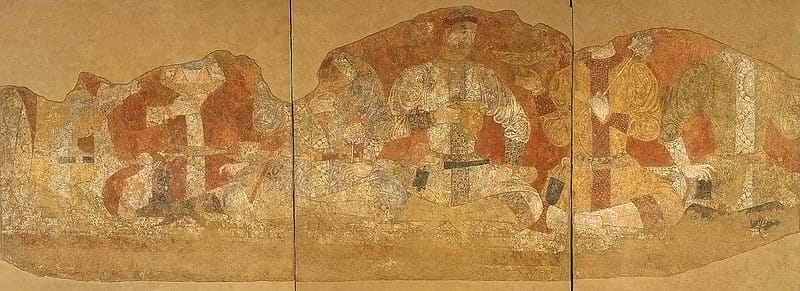
The ruins reveal a surprisingly advanced urban settlement, with temples, markets, residential buildings, fortified walls and impressive painted decorations. Archaeologists discovered very well-preserved frescoes depicting royal ceremonies, battles, religious scenes and everyday life, offering rare insight into this ancient civilisation.

The site is particularly famous for its colourful wall paintings, which are considered among the finest examples of early medieval art in Central Asia. Many original artefacts and fresco fragments are displayed at the Rudaki Museum in Panjakent, named after Abu Abdullah Rudaki, a famous 9th-century Persian poet, singer and musician born in the region.

Visiting the Rudaki Museum

The Rudaki Museum of History and Regional Studies is probably the best place to understand Panjakent’s history. The museum houses archaeological discoveries from Ancient Panjakent, including over 98,000 items from excavations conducted in the Zeravshan Valley.

The exhibits explain the importance of the Silk Road and how different cultures influenced the region over centuries. Even visitors who are not normally interested in museums will appreciate the unique artwork and historical importance of the collections.

Sogdian wall painting
Cross-Cultural Consulting Services/Flickr – Sogdian wall painting

The Seven Lakes of Tajikistan

One of the biggest reasons travellers visit Panjakent is its proximity to the breathtaking Seven Lakes, a chain of turquoise and emerald-coloured lakes hidden among the Fann Mountains.

The lakes are located inside the Hissor Range and are surrounded by steep valleys, traditional villages and snow-covered peaks. Each lake has its own character, with colours ranging from deep blue to bright green depending on the sunlight and minerals in the water:

Mižgon (Nežegon) – At 1,598 m, its name means “eyelashes”. The lake is known for turquoise, blue, and purple shades.

Soja – Located at 1,701 m, its name means “shadow”, referring to its narrow, shaded valley. Its waters range from blue to purple.

Hušër (Gušor/Izšor) – At 1,770 m, its name means “vigilance”, possibly linked to local legends about venomous snakes.

Nofin – Situated at 1,820 m, this long lake is about 2 km wide and is known for occasional reddish hues.

Churdak – At 1,870 m, its name means “small”. It is the smallest of the Seven Lakes.

Marguzor – At 2,139 m, it is the largest and most famous lake, with spectacular light-blue waters and mountain views.

Hazorchashma – The highest lake at 2,400 m, its name means “a thousand springs” due to the many streams feeding it.

The road to the lakes is an adventure itself, passing through narrow mountain valleys and remote settlements. A 4×4 vehicle is usually recommended, especially beyond the lower lakes.

The Fann Mountains: Hiking Paradise

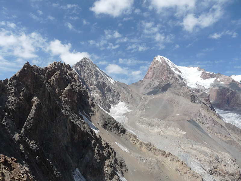
Panjakent is the best gateway to the Fann Mountains, one of the most beautiful mountain regions in Central Asia.

The area offers incredible opportunities for hiking, trekking and photography, with alpine lakes, rugged peaks and untouched valleys. Some of the most famous trekking destinations include Iskanderkul Lake, Chimtarga Peak and the valleys around Artuch.

Iskanderkul Lake is among the most visited natural attractions near Panjakent. Named after Alexander the Great (Iskander in Persian) according to local legends, the lake is around 2,200 metres of altitude and is surrounded by a stunning mountain range. Nearby, visitors can also see Fann Niagara Waterfall, not as impressive as its American cousin, yet still spectacular.

Fann Mountains
photo by Frantisek Trampota/Flickr

Panjakent Bazaar and Local Culture

The modern city of Panjakent is small and easy to explore on foot. The central bazaar is the heart of everyday Tajik life, with an incredible variety of spices, fresh fruit, nuts, bread and many other local products.

The region is also known for its traditional cuisine. Visitors should try plov, the famous Central Asian rice dish prepared with carrots, meat and spices, as well as local bread and dairy products.

Panjakent remains a place where ancient traditions are still visible. The surrounding villages preserve traditional architecture, farming practices and a slower way of life that contrasts strongly with the larger cities of Central Asia.

Best Time to Visit Panjakent

The best time to visit Panjakent is from May to October, when the weather is pleasant and the mountain roads are generally accessible.

Spring (May and June) is an excellent period for visiting, with green valleys, blooming flowers and comfortable temperatures for hiking. The Seven Lakes are particularly beautiful during this season.

Summer (July and August) offers the best conditions for trekking in the Fann Mountains, although temperatures in the city can become hot during the afternoon.

Autumn (September and October) is another ideal time, with cooler weather, fewer tourists and beautiful golden colours in the mountains.

Winter can be challenging because snow may make access to mountain areas difficult, although the city itself remains accessible.

How to Get to Panjakent

The closest major international airport is in Samarkand, Uzbekistan, located about 60 kilometres away. Many travellers combine a visit to Panjakent with a trip to Samarkand, crossing the border between the two countries.

From Samarkand, shared taxis or private transfers can reach Panjakent in around 1.5–2 hours, depending on border procedures.

The city is also connected by road with Dushanbe, the capital of Tajikistan. The journey takes approximately 5–6 hours and crosses spectacular mountain landscapes.

Because public transport options are limited for exploring remote attractions, many travellers choose to hire a driver or join a guided tour, especially for the Seven Lakes and the Fann Mountains.

A minimum of two days is recommended to experience Panjakent’s main highlights. One day can be dedicated to the ancient ruins and museum, while another can be spent exploring nearby natural attractions.

Travellers who enjoy hiking should consider staying three to five days to explore the Seven Lakes, Iskanderkul Lake and the surrounding mountain trails.

Panjakent is still relatively unknown compared with destinations such as Samarkand or Bukhara, making it an excellent choice for travellers looking for authentic experiences, fewer crowds and a deeper connection with Central Asia’s history.

Sine Saloum Delta, Senegal

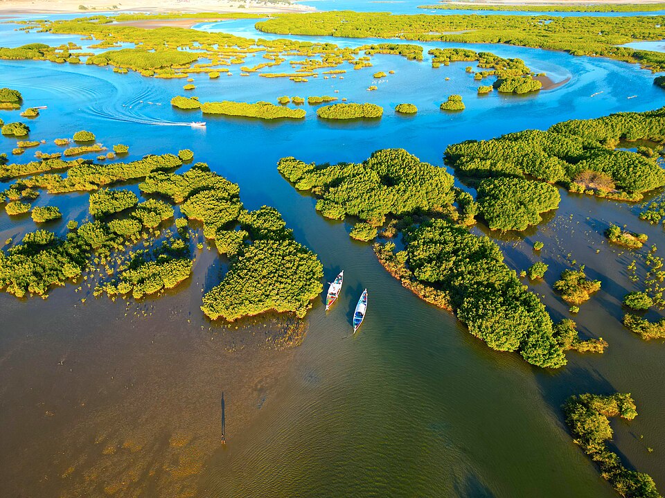
The Sine Saloum Delta is one of Senegal’s most spectacular natural wonders and among the most important wetland ecosystems in West Africa. Located around 150 km south of Dakar, the delta is formed where the Sine and Saloum rivers meet the Atlantic Ocean, creating a maze of mangrove forests, tidal creeks, sandy islands, salt flats, and tranquil lagoons. Recognized as both a UNESCO World Heritage Site and a UNESCO Biosphere Reserve, the region is celebrated for its extraordinary biodiversity and centuries-old cultural heritage. 

Sine Saloum
photo by Issiaga0/Wikimedia Commons

Why Visit the Sine Saloum Delta?

Unlike Senegal’s bustling cities, the Sine Saloum Delta offers a peaceful escape into nature. Visitors can glide through narrow mangrove channels in traditional wooden pirogues, observe hundreds of bird species, visit remote fishing villages, and experience the hospitality of the local Serer and Niominka communities.

The delta covers more than 5,000 km² and includes over 200 islands and islets, making it one of Africa’s most remarkable coastal landscapes. 

Top Attractions

Toubacouta serves as the main gateway to the delta and is an excellent base for boat excursions, kayaking, and wildlife tours.

Palmarin is famous for its peaceful beaches, baobab forests, and nearby salt flats. Visitors can often spot hyenas on guided evening excursions.

Mar Lodj is a charming island village where bicycles, horse carts, and walking are the primary means of transport. It offers a glimpse into traditional island life and beautiful colonial-era architecture.

Fathala Wildlife Reserve, located on the edge of the delta, protects giraffes, zebras, antelopes, rhinos, monkeys, and numerous bird species, making it an excellent addition to any itinerary.

Wildlife and Birdwatching

The Sine Saloum Delta is internationally renowned for birdwatching. More than 400 bird species have been recorded, including pelicans, flamingos, herons, kingfishers, spoonbills, ospreys, and thousands of migratory birds that winter here.

The mangrove ecosystem also supports dolphins, manatees, crocodiles, monitor lizards, monkeys, warthogs, jackals, and countless fish species that sustain local fishing communities. Bird Island hosts one of the world’s largest breeding colonies of royal terns. 

History and Culture

People have lived in the delta for thousands of years. One of its most fascinating features is the presence of hundreds of ancient shell mounds, created by generations of communities harvesting shellfish. Some of these mounds contain burial sites and archaeological remains that provide valuable insight into the history of West Africa.

These remarkable cultural landscapes led to the delta’s inscription as a UNESCO World Heritage Site in 2011. 

Today, fishing, oyster harvesting, salt production, and sustainable agriculture remain central to daily life. Visitors are welcomed into traditional villages where local customs, music, and crafts continue to thrive.

Best Time to Visit

The best time to visit is during the dry season from November to April, when temperatures are pleasant, wildlife is easier to observe, and boat trips are most enjoyable.

Birdwatchers should aim for November to February, when thousands of migratory birds arrive from Europe.

The rainy season, from June to October, transforms the delta into an incredibly lush landscape, although some tracks and villages may become more difficult to access. 

How to Get There

The Sine Saloum Delta lies approximately 2.5 to 4 hours by road from Dakar, depending on your destination within the region.

Most visitors travel by car to Toubacouta, Ndangane, or Palmarin, where local guides organize boat excursions through the mangrove channels. Multi-day stays are highly recommended to fully appreciate the area’s wildlife, culture, and peaceful atmosphere. 

Travel Tips

Bring lightweight clothing, sun protection, insect repellent, and binoculars if you enjoy wildlife photography or birdwatching. Early morning and late afternoon boat trips provide the best opportunities for observing animals and offer the most pleasant temperatures.

Hiring a local guide not only enriches the experience but also supports sustainable tourism and local communities.

Umnak Island, Alaska

Located in the remote Aleutian Islands of Alaska, Umnak Island is one of the most fascinating and isolated destinations in the United States. Shaped by volcanoes, surrounded by the cold waters of the Bering Sea and the North Pacific Ocean, this wild island offers dramatic landscapes, rich wildlife and a glimpse into the traditional life of the Unangax̂ (Aleut) people who have called the region home for thousands of years.

With fewer than 200 permanent residents and no road connection to mainland Alaska, Umnak Island remains one of the least visited places in the state. Travellers who make the difficult journey are rewarded with untouched wilderness, active volcanoes, vast coastal scenery and some of the most remote landscapes in North America.

Umnak Island is the third-largest island in the Aleutian Islands, covering an area of around 1,800 square kilometres. It lies west of Unalaska Island and is separated from it by the narrow Umnak Pass.

The island belongs to the Aleutians West Census Area and is part of one of the most geologically active regions on Earth. The Aleutian chain itself was created by the collision of the Pacific Plate and the North American Plate, forming a long line of volcanoes known as the Aleutian Volcanic Arc.

The landscape of Umnak is dominated by rugged mountains, volcanic valleys, windswept tundra and dramatic cliffs rising from the ocean. Its isolation and harsh climate have preserved an environment that feels almost untouched by modern development.

Mount Vsevidof: The Highest Volcano on Umnak Island

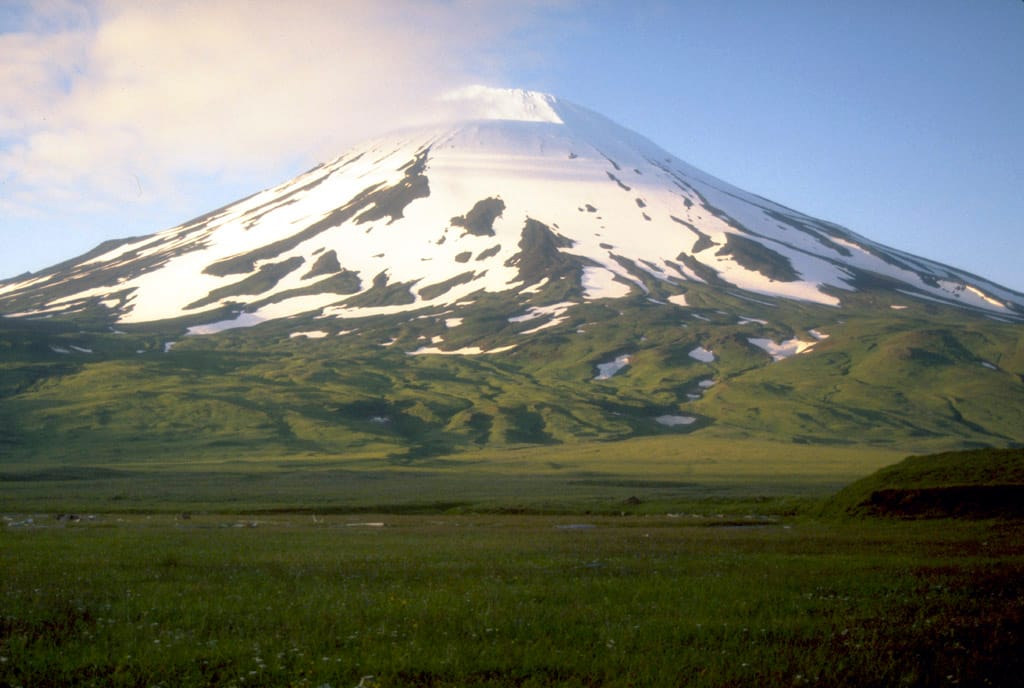
The most iconic natural feature of Umnak Island is Mount Vsevidof, a massive stratovolcano reaching 2,149 metres above sea level. It is the highest point on the island and one of the most impressive volcanoes in the Aleutians.

Although considered dormant, Mount Vsevidof has experienced eruptions in recent geological history, and its perfectly shaped volcanic cone dominates the island’s skyline.

Another important volcanic landmark is Mount Recheshnoi, which rises to 1,984 metres and is known for its geothermal activity. The island contains several hot springs, volcanic fields and steaming areas that reveal the powerful forces still shaping this remote corner of Alaska.

Mount Vsevidof
C. Nye, Alaska Division of Geological and Geophysical Surveys, Public domain, via Wikimedia Commons

Wildlife of Umnak Island

The isolation of Umnak Island has created an ideal environment for wildlife. The surrounding waters are among the richest marine ecosystems in the world, while the island itself provides habitat for many Arctic and sub-Arctic species.

Visitors may encounter:

– Steller sea lions, often seen resting on rocky shores or hunting in coastal waters.
– Sea otters, which are common throughout the Aleutian Islands.
– Puffins, including horned puffins and tufted puffins, nesting on cliffs during the summer months.
– Bald eagles, frequently spotted flying above the coastline.
Caribou, introduced to some Aleutian islands, including populations on Umnak.

The surrounding ocean is also famous for whales, including humpback whales, orcas and grey whales, which pass through the nutrient-rich waters of the Aleutian region.

The Unangax̂ Heritage of Umnak Island

Long before modern settlements appeared, Umnak Island was home to the Unangax̂ people, also known as the Aleut. Their culture developed around the resources of the ocean, with fishing, hunting, and gathering forming the foundation of daily life.

Archaeological evidence shows that the island has been inhabited for more than 8,000 years. Traditional Unangax̂ settlements were often located along protected coastal areas, where communities could access marine resources and travel between islands.

During World War II, Umnak Island became strategically important because of its location near the Pacific theatre. The United States built Fort Glenn, a military airfield on the island, which played a role in defending Alaska against Japanese expansion. Today, abandoned military structures remain scattered across parts of the island, slowly being reclaimed by nature.

Exploring the Island’s Landscapes

Umnak Island is not a conventional tourist destination. There are no large hotels, developed hiking trails, or organised sightseeing infrastructure. Exploration here is about experiencing wilderness rather than following a traditional itinerary.

Some of the most remarkable sights include:

  • Mount Vsevidof, for its dramatic volcanic scenery.
  • The Valley of Ten Thousand Smokes-style volcanic landscapes, with ash-covered valleys and rugged terrain similar to other volcanic regions of Alaska.
  • Remote beaches and coastal cliffs, where wildlife can often be observed without crowds.
  • Hot springs and geothermal areas, showcasing the island’s volcanic activity.

The combination of volcanoes, ocean and tundra makes Umnak a dream destination for photographers, adventurers and travellers looking for truly remote places.

Best Time to Visit Umnak Island

The best time to visit Umnak Island is during the summer months, from June to August.

June and July offer the longest daylight hours and the best conditions for exploring outdoors. Wildlife activity is also at its peak, with seabirds nesting and marine mammals more visible.

August can be a good month for photography, although weather becomes increasingly unpredictable.

The climate remains challenging throughout the year. Even in summer, visitors should expect strong winds, rain, fog and rapidly changing conditions. Winters are extremely harsh, with storms, heavy snowfall and very limited access.

How to Get to Umnak Island

Reaching Umnak Island requires careful planning. The main settlement is Nikolski, located on the western side of the island, and home to one of the most remote communities in Alaska.

The most common route is:

Travel by air from Anchorage to Unalaska/Dutch Harbor, the main transport hub of the Aleutian Islands.

Continue by small aircraft or charter flight to Nikolski on Umnak Island.

There are no roads connecting Umnak Island with other Aleutian communities, and transport within the island is limited. Visitors should be prepared for basic conditions and possible weather-related delays.

Because of the island’s remoteness, most travellers visit with experienced guides, researchers or adventure tourism operators familiar with the Aleutian environment.

Purnululu National Park, Australia

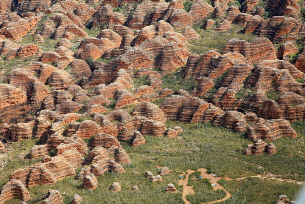
Hidden in the remote Kimberley region of Western Australia, Purnululu National Park is home to one of the world’s most extraordinary geological landscapes. Famous for the iconic Bungle Bungle Range, the park features thousands of beehive-shaped sandstone domes striped with vivid orange and dark grey bands, creating a landscape unlike anywhere else on Earth.

Despite being one of Australia’s greatest natural treasures and a UNESCO World Heritage Site, Purnululu remains surprisingly little visited due to its isolated location. Those who make the journey are rewarded with spectacular hikes, dramatic gorges, Aboriginal cultural heritage and unforgettable aerial views.

Purnululu National Park
W. Bulach, CC BY-SA 4.0, via Wikimedia Commons

Why Visit Purnululu National Park?

Unlike Australia’s more famous destinations such as Uluru or the Great Barrier Reef, Purnululu National Park offers an authentic wilderness experience. The park’s remoteness has preserved its pristine environment, allowing visitors to explore breathtaking landscapes without large crowds.

The highlight is undoubtedly the Bungle Bungle Range, an immense collection of sandstone domes that extends for over 450 square kilometres. Walking among these ancient formations feels like stepping onto another planet.

The Geology Behind the Bungle Bungle Range

The remarkable striped domes are approximately 350 million years old and were formed from layers of sandstone deposited by ancient rivers during the Devonian Period.

Over millions of years, erosion sculpted the soft sandstone into the distinctive rounded towers seen today.

The striking colours result from different biological and mineral processes:

  • The bright orange bands contain iron oxide and dry rapidly after rainfall.
  • The darker grey bands retain more moisture, allowing cyanobacteria to grow on the surface.

Together, these alternating layers create the famous “tiger stripe” appearance visible across the entire range.

The domes generally rise between 200 and 300 metres above the surrounding plains, creating one of the most unique geological landscapes on Earth.

Aboriginal Heritage

The park lies within the traditional lands of the Kija and Jaru peoples, who have lived in this region for tens of thousands of years.

For Indigenous Australians, Purnululu is far more than a geological wonder. Numerous rock shelters, ceremonial sites and ancient artworks demonstrate the deep spiritual connection between the Traditional Owners and this landscape.

The name “Purnululu” is believed to derive from the Kija language, although its precise meaning remains uncertain.

Today, the park is jointly managed with Aboriginal communities, who continue to play an essential role in preserving its cultural heritage.

Cathedral Gorge

One of the park’s most famous attractions is Cathedral Gorge, an enormous natural amphitheatre carved into the sandstone.

After a relatively easy walk through narrow passages between towering domes, visitors reach a circular chamber with nearly vertical walls that create remarkable acoustics. Following seasonal rains, a small pool forms at the base, reflecting the surrounding cliffs.

The silence and natural echo make Cathedral Gorge one of Australia’s most memorable geological sites.

Echidna Chasm

Located in the northern section of the park, Echidna Chasm offers a completely different experience.

The narrow canyon, in places less than one metre wide, is enclosed by vertical rock walls reaching nearly 200 metres high. Around midday, sunlight penetrates the chasm, illuminating the sandstone walls with spectacular shades of orange and gold.

The hike is relatively short but provides some of the park’s most dramatic scenery.

Piccaninny Creek

For adventurous hikers, Piccaninny Creek provides access deep into the heart of the Bungle Bungle Range.

The creek has carved broad valleys between the sandstone domes, offering opportunities for longer day hikes and overnight treks. Walking through this remote landscape allows visitors to fully appreciate the immense scale of the ancient rock formations.

Wildlife

Although the landscape appears harsh, Purnululu supports a surprising diversity of wildlife.

Visitors may encounter:

  • Agile wallabies
  • Euros (common wallaroos)
  • Dingoes
  • Short-beaked echidnas
  • Numerous reptiles
  • More than 130 bird species, including cockatoos, parrots and birds of prey

Many animals are most active during the cooler early morning and late afternoon hours.

Scenic Flights

One of the best ways to appreciate the vastness of Purnululu National Park is from the air.

Scenic helicopter and small aircraft flights reveal the incredible scale of the striped domes, winding gorges and surrounding wilderness. From above, the Bungle Bungles resemble thousands of giant beehives stretching across the landscape.

Many visitors consider the flight to be one of the highlights of their trip to Australia.

Best Time to Visit

The park is generally open between April and October, during the dry season.

The best months are:

  • May to August for cooler hiking temperatures.
  • September for warm weather with fewer visitors.

During the wet season, typically from November to March, heavy rainfall often closes the access road and the park becomes inaccessible.

How to Get There

Reaching Purnululu National Park requires some planning due to its remote location.

Most visitors drive from either Kununurra (approximately 300 km) or Halls Creek (approximately 100 km to the park entrance).

The final 53 kilometres consist of a rough four-wheel-drive track that usually takes around two hours to complete. A high-clearance 4WD vehicle is strongly recommended.

Alternatively, scenic flights depart from both Kununurra and Warmun, providing access for visitors who prefer not to drive.

Visitor Tips

Carry plenty of drinking water, as temperatures can exceed 35°C even during the dry season.

Fuel stations are limited in the Kimberley region, so fill your vehicle before entering the park.

Mobile phone coverage is extremely limited or unavailable.

Camping facilities are available inside the park, while additional accommodation can be found in Kununurra, Warmun and Halls Creek.

Interesting Facts

  • The Bungle Bungle Range remained largely unknown outside Aboriginal communities until the early 1980s.
  • The park became a UNESCO World Heritage Site in 2003.
  • More than 130 bird species have been recorded within the park.
  • Some sandstone layers date back over 350 million years.
  • The famous striped appearance is caused by moisture differences and cyanobacteria growing on the darker bands.
  • Several movies, documentaries and travel productions have featured the Bungle Bungles because of their otherworldly appearance.

Catholic Tours Italy Passion Play Experience: Things to Know 

Community and humility are often the essence of any Catholic tour because spirituality also teaches the value of oneness. It shows the importance of seeking peace and harmony in life. As such, the world is already going through a lot, and everyone, including children, is affected. Whether you wish to renew your faith or strengthen your bond with the Almighty, Catholic tours can help you do so. Many travelers from around the world are embracing these types of holiday plans to reap spiritual and emotional benefits.  

To experience this, you can also embark on a journey to Italy to attend the multi-generational Passion Play. The event takes place in the small town of Sordevolo every five years. It is an opportunity for you to enjoy the region’s traditions, spirituality, and strong sense of community up close. At the same time, it will be amazing to see locals reenact Christ’s final days. You will be overwhelmed to witness their dedication. Here is some more background to help you understand why it may be worth signing up for this once-in-a-lifetime spectacle and cultural tradition. 

Background of the tradition 

You may have come across your friends and family members discussing the Catholic tours Italy Passion Play experience and wondered what makes it so unique. Well, Sordevolo is a little hamlet in Italy, and it hosts the Passion of Christ play every five years in the Elvo Valley. During this time, the entire village becomes a stage for theatrical performances. This tradition has continued since 1816, attracting visitors from around the world. Nearly 400 villagers become actors and give performances in the open-air theater. It can accommodate nearly 3,000 spectators per show. Their dedication, costumes, and emotional performances make the experience deeply memorable for audiences.  

Visitors throng the 4,000-square-meter Amphitheater to immerse themselves in the stories and mysteries of Christ. They appreciate the village’s strong sense of faith. This folk choral theater tradition has survived for more than two centuries as villagers pass its legacy down from generation to generation. Families continue to participate in the performances with great pride. The money earned from the play is used for charities, highlighting its social significance, community support, and heritage value.  

More details 

The Passion Play of Sordevolo 2027 is likely to be held between June and September. Both adults and children perform the same text and plot in its classic setting. Hence, the entire spectacle becomes even more memorable. You cannot take your eyes off the way this centuries-old tradition is carried out. It gives you a glimpse of the village’s deep-rooted faith and cultural pride. This tour can become more enjoyable if you visit the Permanent Museum of the Passion, the Amphitheater, and other sites. You will learn more about the event’s history. For fun, you can also add outdoor activities, such as hiking. Take in the beauty of the Biella Alps and the surrounding landscapes. Local dishes are also tasty. 

Nevertheless, these tours require proper planning and arrangements. Your travel partners must have experience and expertise in this area. If you need help, you can check selectinternationaltours.com.