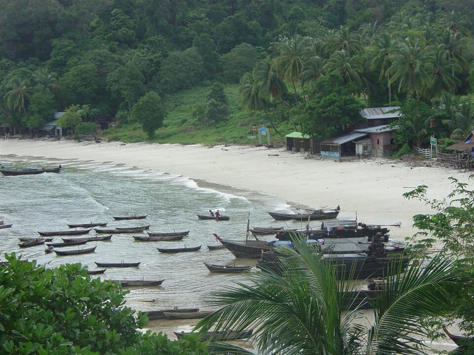
Located in the remote Aleutian Islands of Alaska, Umnak Island is one of the most fascinating and isolated destinations in the United States. Shaped by volcanoes, surrounded by the cold waters of the Bering Sea and the North Pacific Ocean, this wild island offers dramatic landscapes, rich wildlife and a glimpse into the traditional life of the Unangax̂ (Aleut) people who have called the region home for thousands of years.
With fewer than 200 permanent residents and no road connection to mainland Alaska, Umnak Island remains one of the least visited places in the state. Travellers who make the difficult journey are rewarded with untouched wilderness, active volcanoes, vast coastal scenery and some of the most remote landscapes in North America.
Umnak Island is the third-largest island in the Aleutian Islands, covering an area of around 1,800 square kilometres. It lies west of Unalaska Island and is separated from it by the narrow Umnak Pass.
The island belongs to the Aleutians West Census Area and is part of one of the most geologically active regions on Earth. The Aleutian chain itself was created by the collision of the Pacific Plate and the North American Plate, forming a long line of volcanoes known as the Aleutian Volcanic Arc.
The landscape of Umnak is dominated by rugged mountains, volcanic valleys, windswept tundra and dramatic cliffs rising from the ocean. Its isolation and harsh climate have preserved an environment that feels almost untouched by modern development.
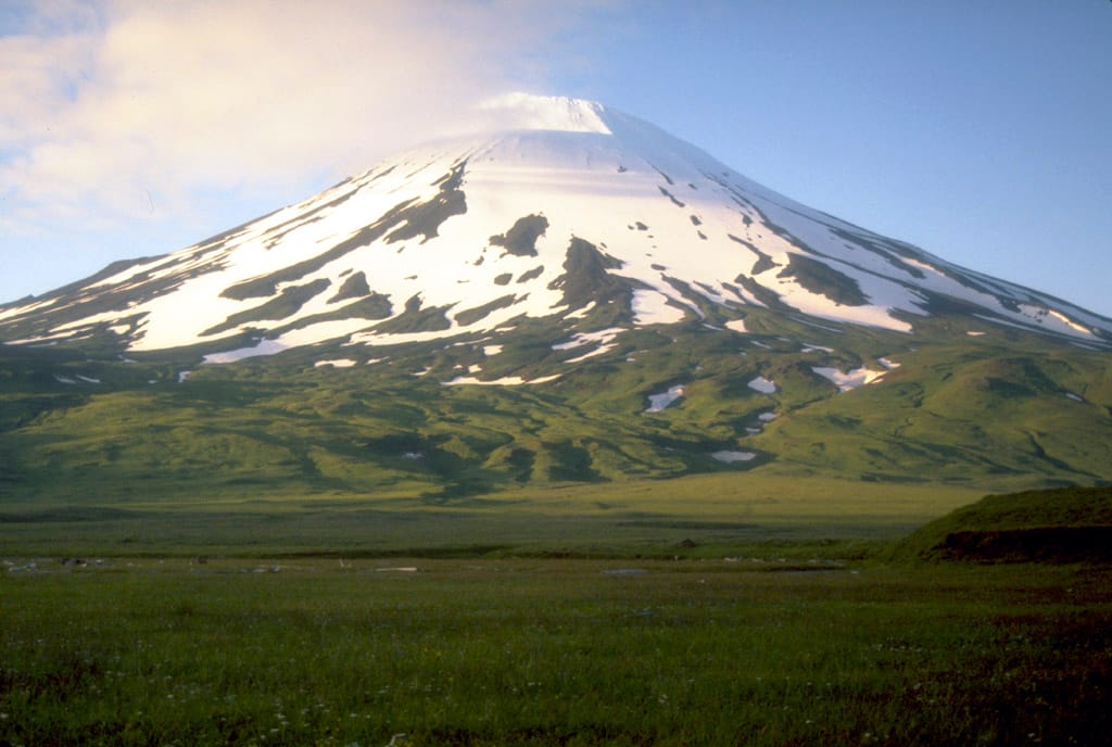
Mount Vsevidof: The Highest Volcano on Umnak Island
The most iconic natural feature of Umnak Island is Mount Vsevidof, a massive stratovolcano reaching 2,149 metres above sea level. It is the highest point on the island and one of the most impressive volcanoes in the Aleutians.
Although considered dormant, Mount Vsevidof has experienced eruptions in recent geological history, and its perfectly shaped volcanic cone dominates the island’s skyline.
Another important volcanic landmark is Mount Recheshnoi, which rises to 1,984 metres and is known for its geothermal activity. The island contains several hot springs, volcanic fields and steaming areas that reveal the powerful forces still shaping this remote corner of Alaska.
The isolation of Umnak Island has created an ideal environment for wildlife. The surrounding waters are among the richest marine ecosystems in the world, while the island itself provides habitat for many Arctic and sub-Arctic species.
Visitors may encounter:
– Steller sea lions, often seen resting on rocky shores or hunting in coastal waters. – Sea otters, which are common throughout the Aleutian Islands. – Puffins, including horned puffins and tufted puffins, nesting on cliffs during the summer months. – Bald eagles, frequently spotted flying above the coastline. Caribou, introduced to some Aleutian islands, including populations on Umnak.
The surrounding ocean is also famous for whales, including humpback whales, orcas and grey whales, which pass through the nutrient-rich waters of the Aleutian region.
The Unangax̂ Heritage of Umnak Island
Long before modern settlements appeared, Umnak Island was home to the Unangax̂ people, also known as the Aleut. Their culture developed around the resources of the ocean, with fishing, hunting, and gathering forming the foundation of daily life.
Archaeological evidence shows that the island has been inhabited for more than 8,000 years. Traditional Unangax̂ settlements were often located along protected coastal areas, where communities could access marine resources and travel between islands.
During World War II, Umnak Island became strategically important because of its location near the Pacific theatre. The United States built Fort Glenn, a military airfield on the island, which played a role in defending Alaska against Japanese expansion. Today, abandoned military structures remain scattered across parts of the island, slowly being reclaimed by nature.
Exploring the Island’s Landscapes
Umnak Island is not a conventional tourist destination. There are no large hotels, developed hiking trails, or organised sightseeing infrastructure. Exploration here is about experiencing wilderness rather than following a traditional itinerary.
Some of the most remarkable sights include:
Mount Vsevidof, for its dramatic volcanic scenery.
The Valley of Ten Thousand Smokes-style volcanic landscapes, with ash-covered valleys and rugged terrain similar to other volcanic regions of Alaska.
Remote beaches and coastal cliffs, where wildlife can often be observed without crowds.
Hot springs and geothermal areas, showcasing the island’s volcanic activity.
The combination of volcanoes, ocean and tundra makes Umnak a dream destination for photographers, adventurers and travellers looking for truly remote places.
Best Time to Visit Umnak Island
The best time to visit Umnak Island is during the summer months, from June to August.
June and July offer the longest daylight hours and the best conditions for exploring outdoors. Wildlife activity is also at its peak, with seabirds nesting and marine mammals more visible.
August can be a good month for photography, although weather becomes increasingly unpredictable.
The climate remains challenging throughout the year. Even in summer, visitors should expect strong winds, rain, fog and rapidly changing conditions. Winters are extremely harsh, with storms, heavy snowfall and very limited access.
How to Get to Umnak Island
Reaching Umnak Island requires careful planning. The main settlement is Nikolski, located on the western side of the island, and home to one of the most remote communities in Alaska.
The most common route is:
Travel by air from Anchorage to Unalaska/Dutch Harbor, the main transport hub of the Aleutian Islands.
Continue by small aircraft or charter flight to Nikolski on Umnak Island.
There are no roads connecting Umnak Island with other Aleutian communities, and transport within the island is limited. Visitors should be prepared for basic conditions and possible weather-related delays.
Because of the island’s remoteness, most travellers visit with experienced guides, researchers or adventure tourism operators familiar with the Aleutian environment.
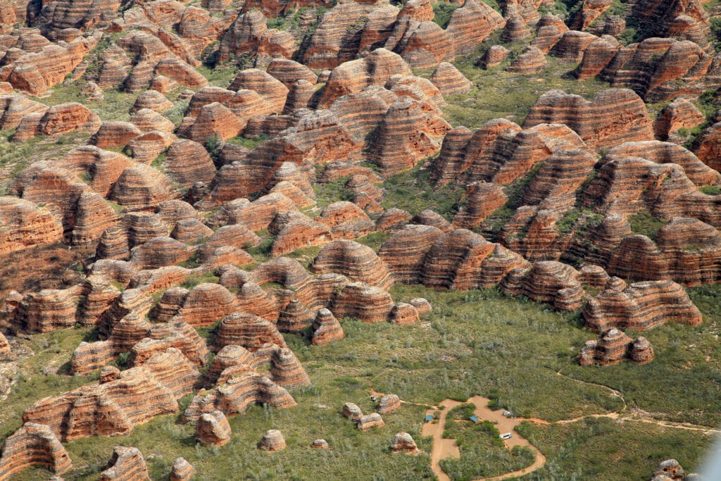
Hidden in the remote Kimberley region of Western Australia, Purnululu National Park is home to one of the world’s most extraordinary geological landscapes. Famous for the iconic Bungle Bungle Range, the park features thousands of beehive-shaped sandstone domes striped with vivid orange and dark grey bands, creating a landscape unlike anywhere else on Earth.
Despite being one of Australia’s greatest natural treasures and a UNESCO World Heritage Site, Purnululu remains surprisingly little visited due to its isolated location. Those who make the journey are rewarded with spectacular hikes, dramatic gorges, Aboriginal cultural heritage and unforgettable aerial views.
Unlike Australia’s more famous destinations such as Uluru or the Great Barrier Reef, Purnululu National Park offers an authentic wilderness experience. The park’s remoteness has preserved its pristine environment, allowing visitors to explore breathtaking landscapes without large crowds.
The highlight is undoubtedly the Bungle Bungle Range, an immense collection of sandstone domes that extends for over 450 square kilometres. Walking among these ancient formations feels like stepping onto another planet.
The Geology Behind the Bungle Bungle Range
The remarkable striped domes are approximately 350 million years old and were formed from layers of sandstone deposited by ancient rivers during the Devonian Period.
Over millions of years, erosion sculpted the soft sandstone into the distinctive rounded towers seen today.
The striking colours result from different biological and mineral processes:
The bright orange bands contain iron oxide and dry rapidly after rainfall.
The darker grey bands retain more moisture, allowing cyanobacteria to grow on the surface.
Together, these alternating layers create the famous “tiger stripe” appearance visible across the entire range.
The domes generally rise between 200 and 300 metres above the surrounding plains, creating one of the most unique geological landscapes on Earth.
Aboriginal Heritage
The park lies within the traditional lands of the Kija and Jaru peoples, who have lived in this region for tens of thousands of years.
For Indigenous Australians, Purnululu is far more than a geological wonder. Numerous rock shelters, ceremonial sites and ancient artworks demonstrate the deep spiritual connection between the Traditional Owners and this landscape.
The name “Purnululu” is believed to derive from the Kija language, although its precise meaning remains uncertain.
Today, the park is jointly managed with Aboriginal communities, who continue to play an essential role in preserving its cultural heritage.
Cathedral Gorge
One of the park’s most famous attractions is Cathedral Gorge, an enormous natural amphitheatre carved into the sandstone.
After a relatively easy walk through narrow passages between towering domes, visitors reach a circular chamber with nearly vertical walls that create remarkable acoustics. Following seasonal rains, a small pool forms at the base, reflecting the surrounding cliffs.
The silence and natural echo make Cathedral Gorge one of Australia’s most memorable geological sites.
Echidna Chasm
Located in the northern section of the park, Echidna Chasm offers a completely different experience.
The narrow canyon, in places less than one metre wide, is enclosed by vertical rock walls reaching nearly 200 metres high. Around midday, sunlight penetrates the chasm, illuminating the sandstone walls with spectacular shades of orange and gold.
The hike is relatively short but provides some of the park’s most dramatic scenery.
Piccaninny Creek
For adventurous hikers, Piccaninny Creek provides access deep into the heart of the Bungle Bungle Range.
The creek has carved broad valleys between the sandstone domes, offering opportunities for longer day hikes and overnight treks. Walking through this remote landscape allows visitors to fully appreciate the immense scale of the ancient rock formations.
Wildlife
Although the landscape appears harsh, Purnululu supports a surprising diversity of wildlife.
Visitors may encounter:
Agile wallabies
Euros (common wallaroos)
Dingoes
Short-beaked echidnas
Numerous reptiles
More than 130 bird species, including cockatoos, parrots and birds of prey
Many animals are most active during the cooler early morning and late afternoon hours.
Scenic Flights
One of the best ways to appreciate the vastness of Purnululu National Park is from the air.
Scenic helicopter and small aircraft flights reveal the incredible scale of the striped domes, winding gorges and surrounding wilderness. From above, the Bungle Bungles resemble thousands of giant beehives stretching across the landscape.
Many visitors consider the flight to be one of the highlights of their trip to Australia.
Best Time to Visit
The park is generally open between April and October, during the dry season.
The best months are:
May to August for cooler hiking temperatures.
September for warm weather with fewer visitors.
During the wet season, typically from November to March, heavy rainfall often closes the access road and the park becomes inaccessible.
How to Get There
Reaching Purnululu National Park requires some planning due to its remote location.
Most visitors drive from either Kununurra (approximately 300 km) or Halls Creek (approximately 100 km to the park entrance).
The final 53 kilometres consist of a rough four-wheel-drive track that usually takes around two hours to complete. A high-clearance 4WD vehicle is strongly recommended.
Alternatively, scenic flights depart from both Kununurra and Warmun, providing access for visitors who prefer not to drive.
Visitor Tips
Carry plenty of drinking water, as temperatures can exceed 35°C even during the dry season.
Fuel stations are limited in the Kimberley region, so fill your vehicle before entering the park.
Mobile phone coverage is extremely limited or unavailable.
Camping facilities are available inside the park, while additional accommodation can be found in Kununurra, Warmun and Halls Creek.
Interesting Facts
The Bungle Bungle Range remained largely unknown outside Aboriginal communities until the early 1980s.
The park became a UNESCO World Heritage Site in 2003.
More than 130 bird species have been recorded within the park.
Some sandstone layers date back over 350 million years.
The famous striped appearance is caused by moisture differences and cyanobacteria growing on the darker bands.
Several movies, documentaries and travel productions have featured the Bungle Bungles because of their otherworldly appearance.
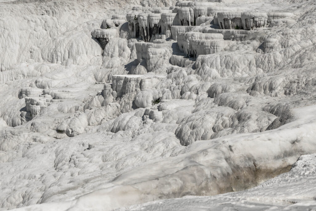
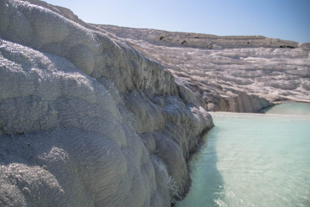
Pamukkale, with its white terraces, pools, and also an ancient city, is one of the most famous natural wonders in Turkey, attracting millions of visitors every year. Located in Denizli Province in southwestern Turkey, this UNESCO World Heritage Site combines stunning natural beauty with thousands of years of history, making it one of the world’s most unique destinations.
The name Pamukkale means Cotton Castle in Turkish, due to the white terraces formed by travertine rocks that cascade down the hillside like frozen waterfalls or snow-covered slopes. Formed by mineral-rich thermal waters flowing down the mountainside for thousands of years, these terraces create a landscape unlike anywhere else in the world.
Geological Formation of Pamukkale
The terraces are the result of natural processes that have been shaping the landscape throughout hundreds of thousands of years. Since the region lies within a tectonically active zone, deep faults in the Earth’s crust allow groundwater to circulate several kilometres below the surface.
As the water travels underground, it is heated by geothermal activity and dissolves minerals (especially calcium carbonate) from the surrounding rocks. The mineral-rich water then rises through fractures and reaches the surface as hot springs with temperatures from approximately 35°C to 100°C.
When the thermal water emerges at the surface, it begins to cool and release carbon dioxide into the atmosphere, permitting calcium carbonate to dissolve, precipitate and solidify, slowly forming the travertine layers. Over thousands of years, these deposits have accumulated and formed the terraces, ridges, and pools that characterise Pamukkale today.
The travertine formations are still growing, making Pamukkale a rare example of an active geological landscape. To protect the fragile formations, authorities carefully manage the water flow across different sections of the terraces, helping preserve their iconic white appearance (when visiting, you might notice some small artificial canals).
Visitors can walk barefoot through designated sections while enjoying panoramic views across the surrounding valley. The shallow pools often reflect the sky, creating spectacular photographic opportunities, particularly during sunrise and sunset.
The thermal waters flowing through the terraces contain high concentrations of dissolved minerals that have attracted visitors for centuries. Although swimming is no longer permitted in most sections to protect the delicate formations, few accessible pools remain available to visitors.
Throughout the day, the appearance of the terraces changes dramatically as sunlight reflects off the brilliant white surfaces. During sunrise and sunset, the travertines often take on soft shades of gold, pink, and orange.
Beyond its geological beauty, Pamukkale is also home to the ancient city of Hierapolis, founded during the 2nd century BC by the kings of Pergamon and one of the best-preserved Greco-Roman spa cities. Standing just beside the terraces, Hierapolis, thanks to the therapeutic reputation of the thermal springs, quickly developed into one of the most important spa destinations in the Roman Empire.
Today visitors can explore a remarkable collection of ancient monuments including the magnificent Roman Theatre, the vast Necropolis, the Temple of Apollo, ancient baths, city gates, and well-preserved streets that reveal the importance of Hierapolis throughout antiquity.
One of the most popular attractions within the ancient city is Cleopatra’s Pool, also known as the Ancient Pool. According to local legend, Cleopatra herself bathed in these waters. Please note that there is a separate charge for admission to the pool.
The thermal pool contains submerged Roman columns and marble fragments that fell into the water following an earthquake centuries ago. Visitors can swim among these ancient ruins while enjoying mineral-rich waters maintained at approximately 36°C throughout the year.
Best Time to Visit
Pamukkale can be visited year-round, but the experience varies depending on the season.
Spring (April to May)
Spring offers pleasant temperatures, green landscapes, and lower visitor numbers. Many travellers consider this the best season to visit.
Summer (June to August)
Summer provides long sunny days and excellent photography opportunities. However, temperatures often exceed 35°C during the afternoon, making early morning and late afternoon visits preferable.
Autumn (September to October)
Autumn combines warm weather with fewer crowds and excellent visibility, making it one of the most comfortable times to explore both the terraces and Hierapolis.
Winter (November to March)
Winter offers a quieter atmosphere and unique scenery as steam rises from the thermal waters during cooler mornings. Although rainfall is more frequent, visitor numbers are significantly lower.
Sunrise is widely regarded as the most magical time to visit. The terraces are quieter, temperatures are cooler, and the soft light creates beautiful reflections across the pools. Make sure to check the opening times, which change with the different seasons. We strongly recommend entering the site at the opening time… go straight to the terraces, and you might have a good chance to get good pictures with almost no people.
Sunset is equally spectacular, with the white travertines reflecting warm shades of orange, pink, and gold. Photographers often remain until closing time to capture the changing colours across the landscape.
How to Get There
Pamukkale is located approximately 20 kilometres north of Denizli. The nearest airport is Denizli Çardak Airport, situated about 70 kilometers away and connected to major Turkish cities, including Istanbul.
Many travellers visit Pamukkale as part of a wider journey through western Turkey, often combining it with Ephesus, Izmir, Bodrum, or Cappadocia. From Izmir, the journey takes around 3 hours by car. While you might consider booking a collective trip from different tourist locations, the best idea remains hiring a car (roads are good and traffic is not impacting your journey).
As we said, be aware that you must remove your shoes before walking on the travertine terraces (to protect the fragile formations). A good idea could be bringing anti-slip socks, as in some points, the ground could be very slippery and you risk falling into the pools with your camera.
Bring sunscreen, sunglasses, and sufficient water, especially during summer.
Nearby Attractions
The region surrounding Pamukkale offers several other fascinating attractions. The ancient city of Laodicea is located only a short drive away and contains some of the most impressive Roman ruins in Turkey.
Visitors can also explore the thermal resorts of the Denizli region, which benefit from the same geothermal system responsible for creating Pamukkale’s famous terraces.
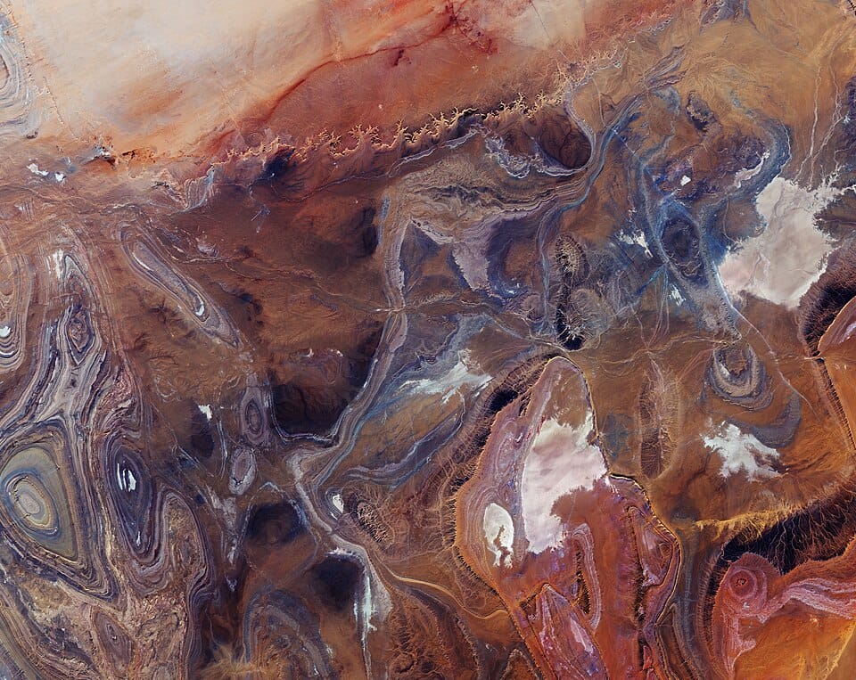
Tanezrouft is one of the most extreme and inhospitable regions of the world, stretching across the Sahara Desert, between southern Algeria and northern Mali. Often referred to as the “Land of Terror” or “Land of Thirst” it is a vast hyper-arid expanse where survival is nearly impossible without modern navigation and supply support.
Located west of the Hoggar Mountains and extending toward the central Sahara plateau, Tanezrouft, is defined by its complete lack of vegetation, water sources, and permanent settlements. Temperatures regularly exceed 50°C in summer, while annual rainfall is measured in only a few millimetres, making it one of the driest places on Earth.
The name “Land of Terror” comes from the extreme danger faced by travellers crossing the region. Historically, caravans avoided Tanezrouft due to its endless barren plains, disorienting landscapes, and absence of wells or oases. Even today, the area is considered one of the most hostile environments in the Sahara, where mechanical failure or getting lost can be life-threatening.
Modern references, including satellite observations and geological studies, highlight the basin’s extreme isolation and harsh climate, reinforcing its reputation as a place where nature offers almost no margin for survival.
Despite its harshness, Tanezrouft is visually striking from above. The terrain is shaped by a combination of ancient geological structures and long-term erosion processes.
The region consists mainly of dark sandstone plateaus, deeply eroded canyons, and exposed folded rock layers dating back hundreds of millions of years. Strong winds, frequent sandstorms, and minimal vegetation have stripped away softer surface materials, revealing dramatic geological patterns beneath.
Satellite imagery shows concentric rings, ridges, and linear folds in the rock strata, creating natural patterns that resemble abstract art. In some areas, canyon walls rise up to 500 metres, while lower basins contain salt flats that indicate past episodes of intermittent water flow.
These formations suggest that the Sahara was not always a desert. Geological evidence indicates that ancient flooding events and wetter climatic periods once shaped the region before long-term desertification transformed it into today’s hyper-arid environment.
Climate and Environmental Extremes
Tanezrouft is classified as a hyperarid desert. Rainfall is extremely rare and often does not exceed a few millimetres per year. The combination of intense solar radiation, dry air, and persistent wind erosion creates a landscape with almost no organic life.
Daytime temperatures can become extreme, while nighttime conditions may drop sharply due to the lack of humidity. The absence of water and vegetation means there are no natural buffers against heat or wind, making exposure particularly dangerous.
Human Presence and Travel
There are no permanent settlements in Tanezrouft. The only human presence comes from occasional Tuareg nomads and modern trans-Saharan routes.
A major highway crosses parts of the region, linking Algeria with Mali, but even this infrastructure highlights the difficulty of the environment, often passing through vast stretches of empty terrain with no services for hundreds of kilometres.
Historically, the region was avoided by caravan routes because of the high risk of dehydration and disorientation. Even today, travellers are advised to treat it as a remote wilderness requiring full logistical preparation.
Geological Importance
Beyond its extreme climate, Tanezrouft is scientifically significant because it exposes deep geological structures that are rarely visible elsewhere. The lack of soil and vegetation allows geologists to study folded sedimentary layers and erosion patterns directly.
The region also provides insight into long-term climatic change in the Sahara, showing how shifting environmental conditions over millions of years transformed a once-variable landscape into one of the driest zones on the planet.
A Landscape of Silence and Scale
What makes Tanezrouft remarkable is not just its hostility, but its scale. The absence of human activity, vegetation, and water creates a landscape where geological time is visible in its raw form. From space, it appears as a vast patterned surface of rock, sand, and erosion lines — one of the most visually dramatic desert regions on Earth.
For geologists and satellite observers, it remains a natural laboratory. For travellers, it remains a place that demands respect, preparation, and caution.
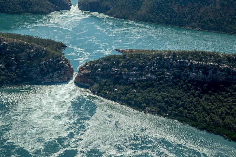
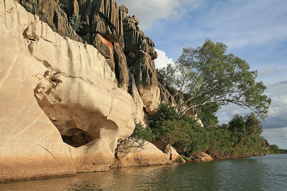
Located in the remote Kimberley region of Western Australia, the Horizontal Falls, also known as Garaanngaddim, are among the country’s most peculiar natural attractions. Despite their name, they are not true waterfalls but a unique tidal phenomenon where enormous volumes of seawater are forced through two narrow coastal gorges, creating powerful horizontal torrents that resemble rivers flowing sideways.
Described by naturalist Sir David Attenborough as “one of the greatest natural wonders of the world,” the Horizontal Falls offer visitors an unforgettable combination of dramatic scenery, thrilling boat rides, and one of the largest tidal movements on Earth.
The Horizontal Falls are located in Talbot Bay, Buccaneer Archipelago, approximately 250 km (155 miles) northeast of Broome. The bay lies inside a maze of more than 800 rugged islands formed from ancient sandstone ridges that have been sculpted by millions of years of erosion.
Their isolated location means there are no roads leading to the falls. Visitors must arrive by seaplane, helicopter, or expedition cruise, making the journey part of the adventure.
Unlike traditional waterfalls created by rivers dropping over cliffs, the Horizontal Falls are produced entirely by the ocean tides.
The Kimberley Coast experiences some of the highest tidal ranges in Australia, often exceeding 10 metres (33 ft). As the tide rises or falls, billions of litres of seawater rush through two extremely narrow gaps separating the cliffs.
The two openings differ significantly in width:
– The wider gap measures approximately 20 metres (66 ft). – The narrower gap is only about 10 metres (33 ft) wide.
Because these passages cannot accommodate the massive volume of incoming or outgoing water quickly enough, the sea level on one side becomes temporarily higher than on the other. This difference creates powerful horizontal waterfalls, with water surging through the gaps at speeds exceeding 20 km/h (12 mph) during peak tides.
The direction of flow reverses roughly every six hours as the tide changes.
A Geological Landscape Over 1.8 Billion Years Old
The surrounding cliffs belong to one of Earth’s oldest exposed rock formations. The reddish sandstone of the Kimberley dates back approximately 1.8 billion years, making it significantly older than many of the world’s famous mountain ranges.
Over geological time, faults, erosion and repeated sea level changes carved the deep channels that now funnel the tidal waters through the narrow openings.
Wildlife Around the Horizontal Falls
The remote location has helped preserve an exceptionally rich marine ecosystem.
The surrounding mangroves, reefs and islands provide important breeding habitats for numerous marine species.
The Thrilling Boat Ride
One of the highlights of visiting the Horizontal Falls is travelling through the narrow gaps aboard specially designed high-powered jet boats.
The boats navigate the turbulent currents created by the tides, offering an exhilarating ride through the rushing water while experienced skippers carefully time each crossing according to tidal conditions.
For visitors seeking a less adventurous experience, many tours also include scenic cruising around the islands and calm-water wildlife viewing.
Scenic Flights Above the Kimberley
Many visitors consider the seaplane flight to be just as spectacular as the falls themselves.
Flying over the Buccaneer Archipelago reveals an extraordinary landscape of turquoise lagoons, countless islands, winding channels and dramatic sandstone cliffs. From the air, the contrasting colours of the tidal currents become clearly visible, offering a perspective impossible to appreciate from sea level.
Indigenous Cultural Significance
The Horizontal Falls lie within the traditional lands and sea country of the Dambimangari people, who have cared for this region for thousands of years.
Known as Garaanngaddim, the site holds deep cultural and spiritual importance. Visitors are encouraged to respect Indigenous heritage and follow guidance provided by local Traditional Owners and licensed tour operators.
Visiting the Horizontal Falls Today
Due to concerns about environmental protection and the cultural significance of the area, tourism practices have evolved in recent years. Scenic flights, cruises and wildlife experiences remain available, while commercial boat operations passing directly through the narrow gaps are being progressively phased out under agreements with Traditional Owners and the Western Australian Government.
Even without travelling through the falls themselves, witnessing the immense tidal forces from nearby or from the air remains one of Australia’s most remarkable natural experiences.
Best Time to Visit
The ideal period is during the dry season, from May to September, when weather conditions are stable and skies are generally clear.
The largest tidal movements occur around the new moon and full moon, producing the most dramatic flows through the gorges. Tour operators schedule departures according to daily tide tables to maximise the experience.
How to Get There
The main departure point is Broome, with numerous operators offering full-day excursions that typically include scenic flights, cruises and meals.
Other options include:
– Luxury expedition cruises along the Kimberley Coast – Small-ship cruises departing from Derby or Broome – Private helicopter or seaplane charters
Most day tours last between 8 and 12 hours, depending on the itinerary.
Visitor Tips
Book several months in advance during the dry season, as places often sell out. Wear lightweight clothing, sunglasses, sunscreen and a hat, and bring a camera with plenty of storage: the aerial scenery is among Australia’s most photogenic landscapes. Motion sickness medication may be useful for visitors sensitive to rough water or small aircraft.
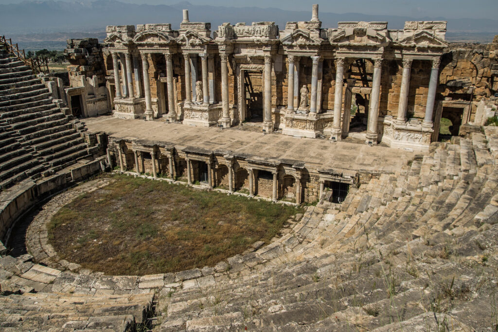
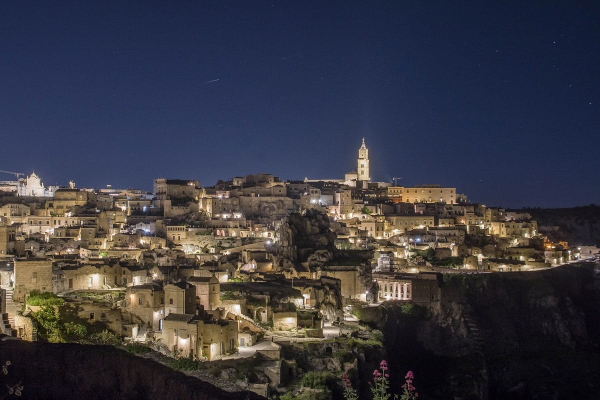
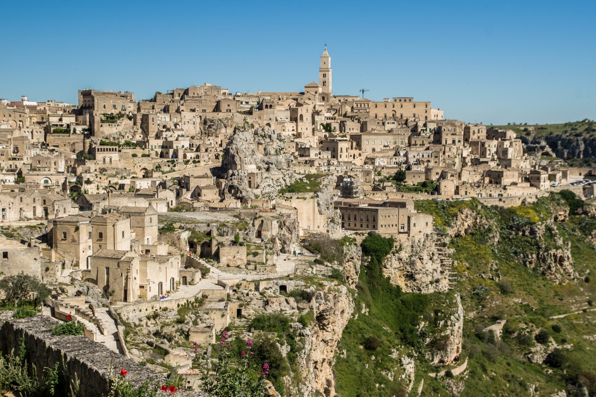
Matera is one of the most unique and ancient cities in Europe, located in the southern region of Basilicata. Famous for its extraordinary cave dwellings carved into limestone rock, known as the Sassi di Matera, the city offers a rare glimpse into a form of human settlement that dates back over 9,000 years. Recognised as a UNESCO World Heritage Site and named the European Capital of Culture 2019, Matera has transformed from a symbol of poverty into one of Italy’s most fascinating travel destinations. Its UNESCO recognition is not only due to its visual impact, but also to its extraordinary system of water collection and management, a highly advanced network of cisterns and channels that sustained life in the Sassi for thousands of years.
Spectacular night view of the Sassi, photo by mytouristmaps.com
The Sassi Districts
The heart of Matera lies in the ancient districts of Sasso Caveoso and Sasso Barisano, where homes, churches, and even hotels are carved directly into the rock. Walking through these areas feels like stepping back in time, with narrow alleys, stone staircases, and panoramic terraces overlooking the dramatic canyon of the Gravina di Matera.
The Sasso Caveoso retains a more authentic and raw appearance, resembling its historical state, while Sasso Barisano has been more extensively restored and offers a higher concentration of accommodations and restaurants.
Matera is home to over 150 rock churches, many adorned with Byzantine frescoes. Among the most remarkable is Santa Maria de Idris, carved into a large rock pinnacle, and San Pietro Barisano, the largest cave church in the city.
Things to Do in Matera
Exploring Matera is all about slow travel and immersion. Wander through the Sassi, discover hidden viewpoints, and enjoy local cuisine in cave restaurants.
Key experiences include visiting the Palombaro Lungo, a short but fascinating visit to an underground cistern that highlights the city’s ingenious water system. Exploring the traditional house caves, such as the Casa Grotta di Vico Solitario, gives a deeper understanding of daily life in the past, while a visit to Casa Noha helps contextualise the entire city before diving into the Sassi.
One of the most rewarding experiences is simply getting lost in the Sassi. Despite the constant presence of tourism, it is surprisingly easy to find quiet corners, panoramic terraces, and hidden alleys where you can be completely alone.
Another highlight is reaching Belvedere Murgia Timone, one of the most spectacular viewpoints over Matera. It can be accessed on foot from the city via a scenic hike (ticket required), crossing the canyon and even passing through a Tibetan bridge. Alternatively, you can drive to the Parco della Murgia Materana (a protected natural area filled with prehistoric caves, rupestrian churches, and hiking trails) and reach the viewpoint by shuttle or by renting a bike, which is a great option to explore the area more freely. Get there at sunrise for the best lights.
Matera is also a popular filming location, featured in movies like Mel Gibson’s The Passion of the Christ and the James Bond movie No Time to Die.
photo by mytouristmaps.com
Food in Matera
The cuisine of Matera is deeply rooted in peasant traditions, with simple ingredients transformed into rich and flavourful dishes. Among the most iconic is pignata, a slow-cooked meat stew prepared in a terracotta pot, traditionally cooked for hours over a low flame. Another must-try is peperoni cruschi, crispy dried red peppers typical of Basilicata, often served as a side or added to pasta for extra flavour and crunch.
Bread also plays a central role in local gastronomy, especially the famous Pane di Matera, known for its distinctive shape and intense taste.
For an unforgettable dining experience, head to Via Bruno Buozzi, one of the best areas to find excellent restaurants. Here, many venues are set inside caves, offering not only high-quality traditional food but also an incredible atmosphere, with candlelit interiors carved into the rock and stunning views over the Sassi.
Best Time to Visit Matera
The best time to visit Matera is during spring (April to June) and early autumn (September to October), when temperatures are pleasant and the city is less crowded. Summers can be very hot, often exceeding 35°C, while winters are quieter but can feel chilly due to the stone environment.
Visiting in the evening is highly recommended, as the Sassi become beautifully illuminated, creating an unforgettable atmosphere.
Matera does not have its own airport, but it is well connected to nearby cities. The closest airport is Bari, about 65 km away.
From Bari, you can reach Matera by train using the Ferrovie Appulo Lucane line, which takes around 1.5 hours. Alternatively, buses and car rentals offer more flexibility, especially if you plan to explore the surrounding region.
Driving is a convenient option, particularly for visiting the Murgia Plateau and nearby attractions like Alberobello or Castelmezzano.
Nearby Attractions
Within a short drive, you can explore some of southern Italy’s most stunning landscapes. Highlights include Alberobello, famous for its trulli houses, and the dramatic peaks of the Dolomiti Lucane near Castelmezzano and Pietrapertosa.
For nature lovers, the Pollino National Park offers hiking and wildlife experiences, while the Ionian coast provides beautiful beaches less than an hour away.
The most unforgettable cruises on Earth are not the giant ocean liners crossing the Caribbean or Mediterranean (we actually don’t like them), but immersive journeys through rivers, fjords, jungles, wetlands, and remote coastlines. These routes bring travellers into direct contact with wildlife, ancient civilisations, and sometimes even places that are impossible to reach by road.
From drifting past ancient temples on the Nile River to searching for orangutans deep in the rainforests of Borneo or navigating among limestone islands in Southeast Asia, these cruises offer experiences that go far beyond traditional sightseeing. Many of them are destinations in their own right, combining culture, history, wildlife, and spectacular scenery into a single journey.
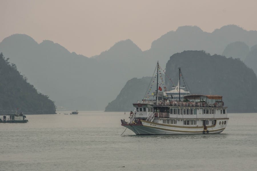
The Ha Long Bay cruise explores one of Southeast Asia’s most spectacular landscapes, where thousands of limestone islands rise dramatically from emerald-green waters. Recognised as a UNESCO World Heritage Site, the bay is renowned for its unique geology and breathtaking scenery.
Most cruises last between one and three days, allowing visitors to kayak through hidden lagoons, explore impressive caves such as Sung Sot Cave, and visit floating fishing villages that have existed for generations. Early mornings often bring a mystical atmosphere as mist drifts among the karst formations.
Although very touristy and with hundreds of boats (you won’t even notice other boats when mesmerised by the scenery), Ha Long Bay remains one of Asia’s most photographed and memorable cruising destinations.
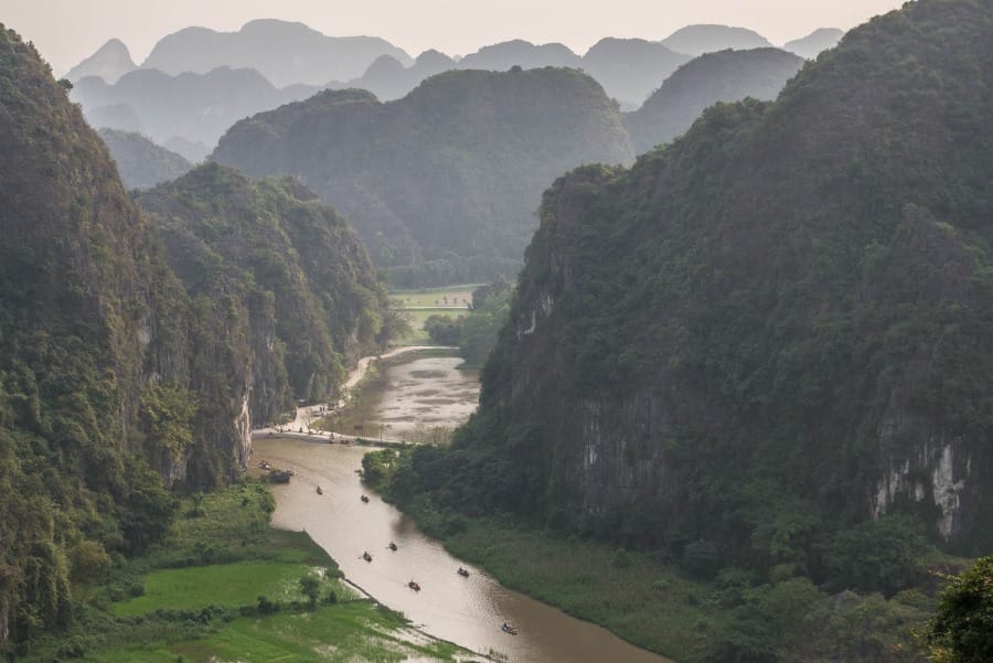
The boat cruises of Ninh Binh, particularly around Trang An and Tam Coc, may be relatively short, but they offer some of the most impressive inland scenery in Asia. Often called “Ha Long Bay on land,” the region is characterised by limestone mountains rising dramatically above rice fields and winding waterways.
Passengers travel in small rowing boats guided by local residents who row with their legs instead of the traditional way (requires less physical effort – smart people…), gliding through caves, narrow channels, and peaceful valleys inaccessible by road. Depending on the season, the surrounding rice paddies create vivid green or golden landscapes that enhance the beauty of the journey.
The combination of geology, agriculture, and traditional rural life creates a peaceful atmosphere and an unmissable day trip from Hanoi.
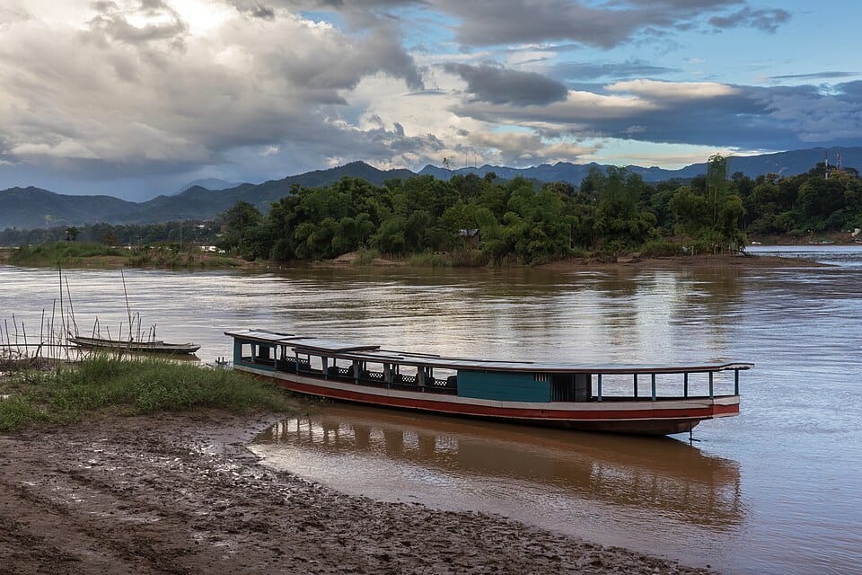
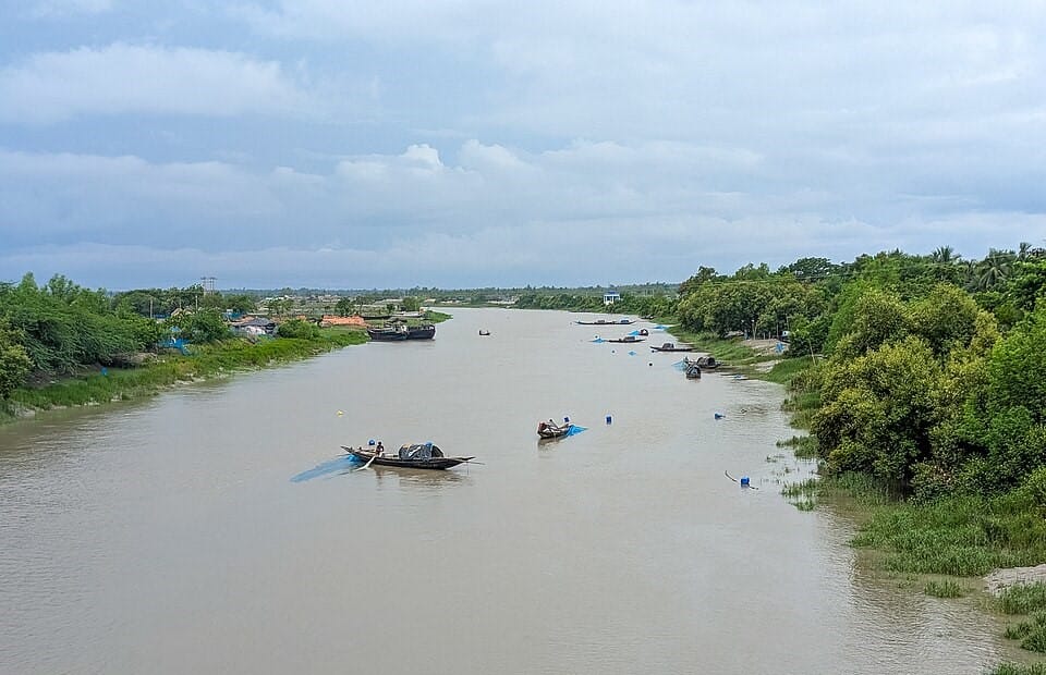
The Mekong River cruise offers a fascinating journey through two of Southeast Asia’s most culturally rich countries. Flowing through Vietnam and Cambodia, the river remains a vital transportation route and source of livelihood for millions of people.
Cruises pass floating markets, rice fields, riverside villages, Buddhist temples, and bustling towns where life continues much as it has for generations. The famous Cai Rang Floating Market provides a glimpse into traditional river commerce, while cultural visits reveal local crafts, cuisine, and customs.
Many itineraries conclude near Angkor Wat, creating a perfect combination of river exploration and one of the world’s most celebrated archaeological sites. The Mekong provides an authentic insight into everyday life rarely experienced by independent travellers.
The Mekong Delta is often called Vietnam’s “rice bowl” and offers one of the most authentic river experiences in Asia. Unlike longer Mekong cruises, these journeys focus on the intricate network of canals and waterways that support local communities.
Passengers navigate narrow channels lined with coconut palms, fruit orchards, floating markets, and traditional wooden homes. Small boats provide access to areas where agriculture and fishing remain central to daily life.
The delta’s culture is deeply connected to the river, and visitors frequently observe floating markets, family workshops, and riverside farms operating much as they have for decades. The slower pace and close interaction with local communities make this one of Vietnam’s most rewarding cultural experiences.
The Tanjung Puting River Cruise is one of Indonesia’s most remarkable wildlife adventures. Travelling aboard traditional wooden klotok boats through Tanjung Puting National Park in Central Kalimantan, visitors gain access to some of Borneo’s most important rainforest habitats.
The primary attraction is the opportunity to observe wild and rehabilitated orangutans, including visits to the famous Camp Leakey research and conservation centre. Along the river, travellers may also encounter proboscis monkeys, macaques, hornbills, kingfishers, and crocodiles.
The slow pace of the cruise allows guests to fully appreciate the rainforest environment, with jungle sounds providing a constant backdrop. Few wildlife experiences in Southeast Asia offer such close encounters with one of humanity’s closest relatives.
The Komodo Islands Cruise explores one of Indonesia’s most fascinating regions, centred around Komodo National Park, a UNESCO World Heritage Site located between the islands of Flores and Sumbawa.
The main attraction is the legendary Komodo dragon, the world’s largest living lizard. Guided walks on Komodo and Rinca Islands allow visitors to observe these remarkable reptiles in their natural habitat. Beyond wildlife, the region features rugged volcanic landscapes like the beautiful Padar Island (the view from the top is quite spectacular – check my profile picture in the “about mTm” section), crystal-clear waters, and spectacular marine biodiversity with world-class diving and snorkelling sites.
Many itineraries include snorkelling and diving among colourful coral reefs, as well as visits to the famous Pink Beach (again, Padar Island), where crushed red coral creates unusually coloured sand. The combination of wildlife, scenery, and marine life makes this one of Southeast Asia’s most diverse cruises.
Located off the coast of West Papua, Raja Ampat is widely regarded as one of the richest marine ecosystems on Earth. The archipelago consists of more than 1,500 islands scattered across brilliant turquoise waters.
Liveaboard cruises provide access to remote areas inaccessible to day boats, allowing visitors to experience pristine coral reefs, hidden lagoons, and spectacular limestone formations. Underwater, the biodiversity is extraordinary, with manta rays, reef sharks, sea turtles, and hundreds of fish species.
Even travellers who do not dive will find plenty to enjoy, including kayaking, island hikes, and viewpoints overlooking countless jungle-covered islands. Raja Ampat remains one of the last truly untouched marine frontiers in the world.
Best time: October to April
Kinabatangan River Cruise, Malaysia
Cruise length: ~20–80 km
Photo by CEphoto, Uwe Aranas
The Kinabatangan River in Malaysian Borneo is considered one of Southeast Asia’s best wildlife destinations. Flowing through rainforest, wetlands, and floodplains, it supports an exceptional concentration of animal species within a relatively accessible area.
Morning and evening cruises provide opportunities to observe orangutans, proboscis monkeys, crocodiles, hornbills, and the rare Bornean pygmy elephant. Because much of the surrounding forest is fragmented, wildlife is often easier to spot than in larger continuous rainforest regions.
The constantly changing river environment creates excellent viewing conditions throughout the day, while experienced guides help identify species hidden among the vegetation. For many visitors, the chance to see multiple iconic Bornean animals in a single cruise is the highlight of their trip.
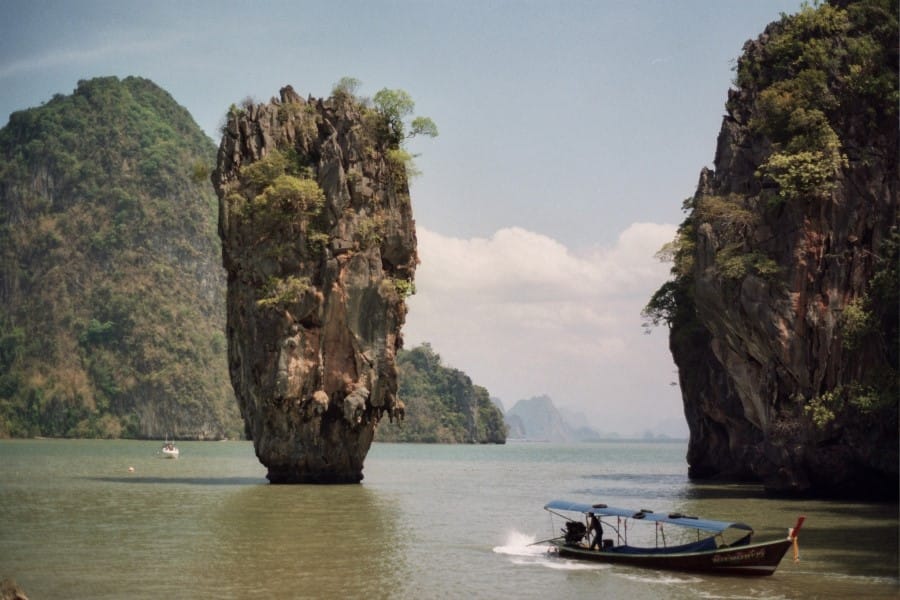
The Phang Nga Bay cruise explores one of Thailand‘s most recognisable coastal landscapes, located between Phuket and the mainland. The bay is famous for dramatic limestone towers rising vertically from emerald-green waters.
Cruises navigate through a maze of islands, hidden lagoons, mangrove forests, and sea caves carved by thousands of years of erosion. One of the most famous landmarks is James Bond Island, which gained international fame after appearing in The Man with the Golden Gun.
Many excursions include kayaking through cave systems that open into secluded lagoons completely enclosed by towering cliffs. The combination of tropical scenery, unusual geology, floating villages and calm waters makes Phang Nga Bay one of the most visually impressive cruising destinations in Asia.
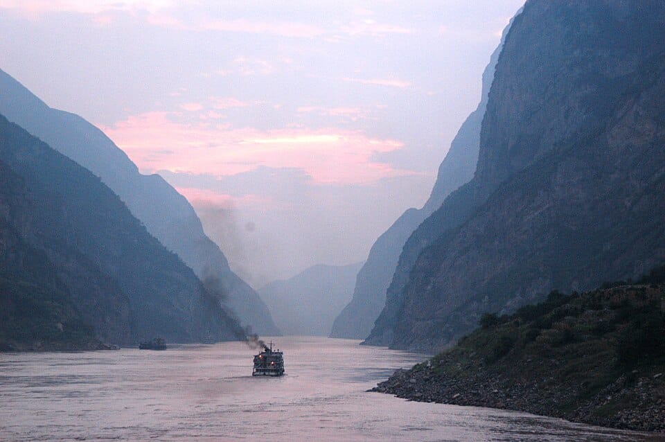
The Yangtze River is Asia’s longest river and one of China’s most important waterways. Cruises are best known for passing through the spectacular Three Gorges, a region of dramatic cliffs, narrow canyons, and mountain scenery.
Along the route, travellers encounter ancient temples, riverside towns, and cultural landmarks that reflect thousands of years of Chinese history. The journey also includes views of the immense Three Gorges Dam, one of the largest hydroelectric projects ever built.
The combination of natural beauty, engineering achievements, and cultural significance makes the Yangtze one of Asia’s most popular inland cruise destinations and an excellent introduction to central China.
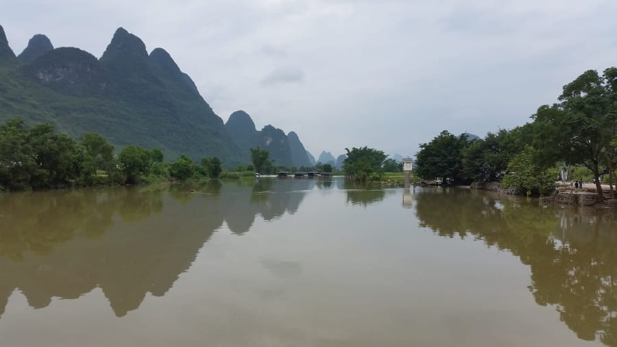
The Li River Cruise between Guilin and Yangshuo is one of China’s most famous scenic journeys. The route passes through a landscape of limestone karst mountains that has inspired Chinese artists and poets for centuries.
The river winds through peaceful countryside dotted with bamboo groves, small villages, water buffalo, and traditional fishing boats. The dramatic peaks rising from the surrounding plains create one of the most recognisable natural landscapes in Asia.
The cruise offers a relaxing way to experience a region that combines outstanding scenery with cultural heritage. Upon arrival in Yangshuo, travellers can continue exploring by bicycle, boat, or on foot through some of China’s most beautiful countryside.
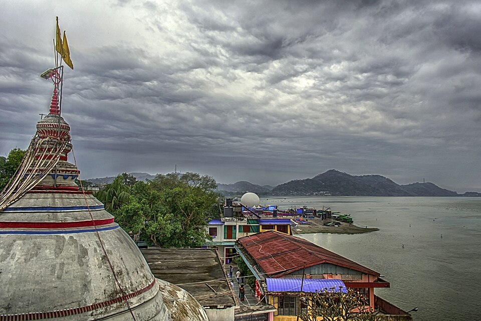
The Brahmaputra River flows through the northeastern Indian state of Assam, creating one of Asia’s most distinctive cruise experiences. The river passes tea plantations, wetlands, rural communities, and wildlife-rich landscapes largely untouched by mass tourism.
One of the main highlights is proximity to Kaziranga National Park, a UNESCO World Heritage Site famous for its population of one-horned rhinoceroses. Wildlife sightings may also include elephants, river dolphins, water buffalo, and numerous bird species.
The combination of natural beauty, local culture, and excellent wildlife opportunities makes the Brahmaputra a fascinating alternative to more established river cruises in Asia.
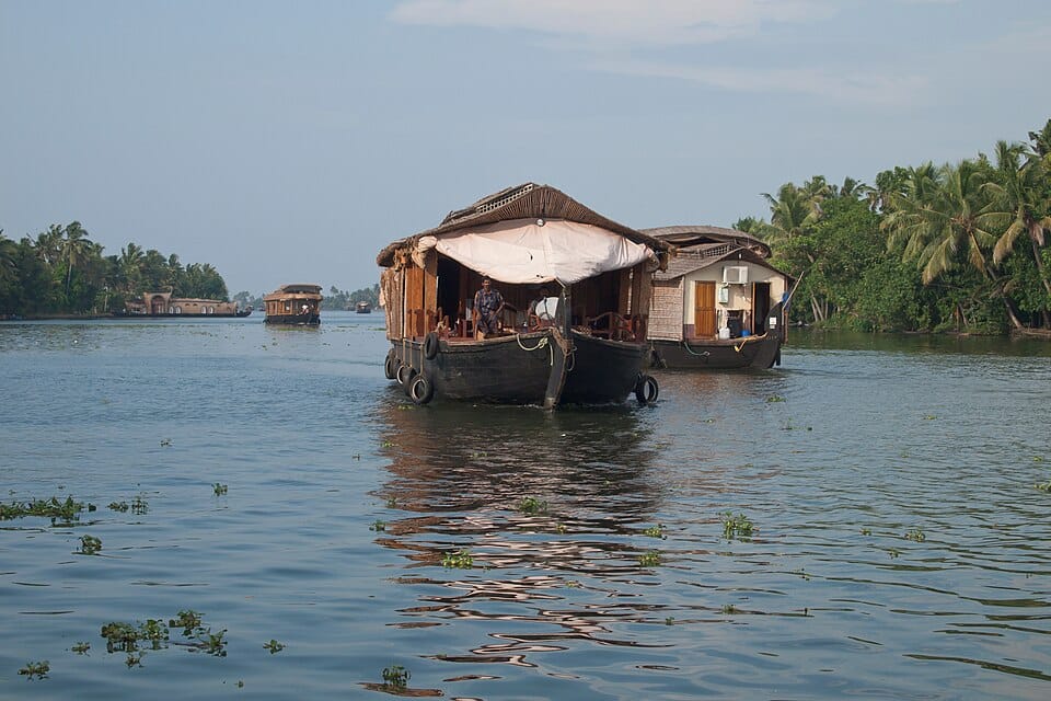
The Kerala Backwaters Cruise offers a peaceful journey through a network of lagoons, lakes, rivers, and canals along India’s southwestern coast. Traditional houseboats, known as kettuvallams, provide a comfortable way to explore this unique landscape.
The route passes rice paddies, coconut plantations, fishing villages, temples, and colourful local markets. Daily life unfolds along the water, with people using boats for transport, fishing, and commerce much as they have for generations.
Unlike many wildlife-focused cruises, Kerala’s appeal lies in its cultural atmosphere, tranquil scenery, and slow pace. It remains one of India’s most distinctive travel experiences and a perfect contrast to the country’s busy cities.
The Sundarbans River Cruise explores the world’s largest mangrove forest, a UNESCO World Heritage Site shared between India and Bangladesh. This vast delta is formed by the Ganges, Brahmaputra, and Meghna rivers before they enter the Bay of Bengal.
Cruises navigate a maze of tidal waterways, mudflats, and mangrove islands that support remarkable biodiversity. The region is most famous as the home of the elusive Royal Bengal Tiger, although sightings are rare. Other wildlife includes crocodiles, spotted deer, monkeys, river dolphins, and hundreds of bird species.
The combination of wilderness, wildlife, and remote landscapes makes the Sundarbans one of Asia’s most unusual and adventurous river journeys.
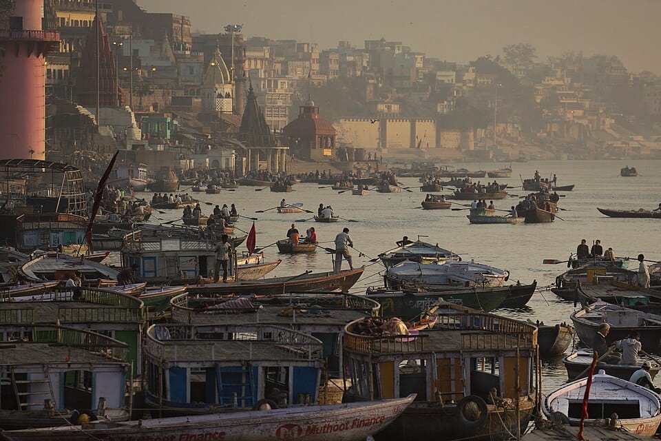
The Ganges River Cruise follows India’s most sacred river, offering a unique combination of spirituality, culture, and history. Depending on the itinerary, cruises may pass through major cities, ancient temples, rural villages, and important pilgrimage sites.
One of the highlights is Varanasi, where daily religious ceremonies along the ghats provide one of the most powerful cultural experiences in India. Further along the route, travellers encounter Mughal architecture, colonial heritage, and traditional riverside communities.
The Ganges is far more than a river; it is a central part of Indian identity. A cruise along its waters provides an exceptional insight into the country’s history, religion, and daily life.
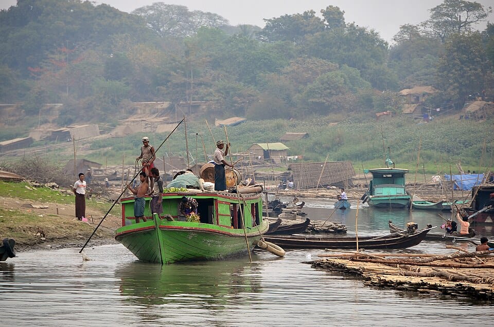
The Irrawaddy River has long served as the cultural and economic backbone of Myanmar. Cruises between Mandalay and Bagan offer an exceptional introduction to the country’s history, traditions, and rural life.
The journey passes villages, monasteries, pagodas, and agricultural landscapes that remain largely unchanged by modern development. The highlight for many visitors is Bagan, home to thousands of ancient Buddhist temples spread across a vast archaeological plain.
Compared with busier waterways elsewhere in Asia, the Irrawaddy offers a slower and more authentic experience, combining beautiful scenery with some of Southeast Asia’s most important historical treasures.
The Mergui Archipelago consists of more than 800 islands scattered across the Andaman Sea off the coast of southern Myanmar. Largely undeveloped and difficult to access, it remains one of Southeast Asia’s last true island frontiers.
Expedition cruises navigate between uninhabited islands, hidden bays, white-sand beaches, and coral reefs that have experienced relatively little tourism. Snorkelling and diving are major attractions, with opportunities to observe sea turtles, reef sharks, colourful tropical fish, and healthy coral ecosystems.
The region is also home to the Moken, a traditionally nomadic sea-faring people who have lived in these waters for generations. The combination of isolation, natural beauty, and cultural uniqueness makes the Mergui Archipelago one of Asia’s most intriguing cruise destinations.
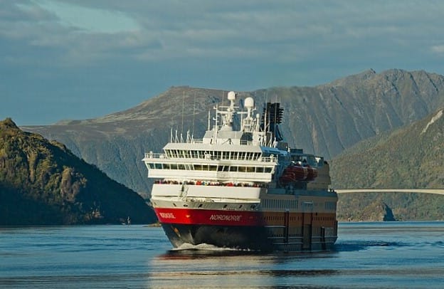
The Hurtigruten Coastal Express is one of the world’s great coastal voyages, following Norway‘s spectacular shoreline from Bergen to Kirkenes. Originally established as a postal and passenger service, it has evolved into a unique combination of transportation route and expedition-style cruise.
The journey visits more than 30 ports and passes through deep fjords, remote islands, Arctic settlements, and traditional fishing communities. Highlights include the dramatic Lofoten Islands, the rugged coastline of Helgeland, and multiple crossings of the Arctic Circle. Wildlife sightings often include sea eagles, seals, porpoises, and occasionally whales.
The experience changes dramatically throughout the year. Summer brings endless daylight under the midnight sun, while winter transforms the route into one of Europe’s best opportunities to witness the northern lights over snow-covered landscapes and icy seas.
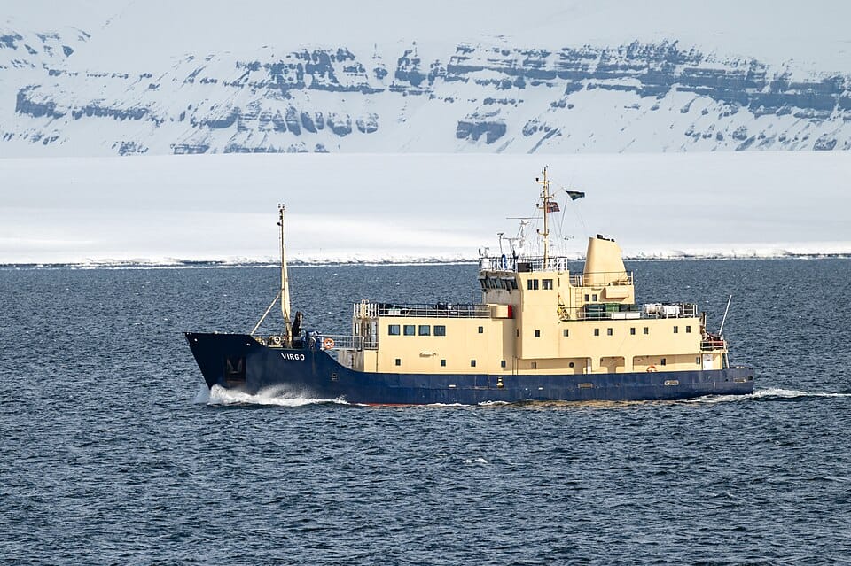
The Svalbard Expedition Cruise explores one of the northernmost inhabited regions on Earth, located halfway between mainland Norway and the North Pole. Departing mainly from Longyearbyen, these voyages navigate through ice-filled fjords, glacier-lined coastlines, and remote Arctic wilderness.
Unlike traditional cruises, expedition routes remain flexible and adapt to wildlife activity and sea ice conditions. The region is famous for its polar bears, but travellers may also encounter walruses, Arctic foxes, reindeer, beluga whales, and immense seabird colonies nesting along dramatic cliffs.
The landscape is dominated by glaciers, floating icebergs, and barren mountains illuminated by 24-hour daylight during summer. Zodiac landings provide opportunities to explore isolated beaches, abandoned mining settlements, and historic sites connected to the early era of Arctic exploration.
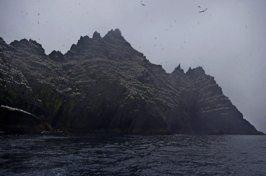
A cruise to the Skellig Islands is one of Ireland’s most spectacular maritime experiences, taking visitors into the (sometimes rough – we got soaked on the small boat!) wild Atlantic waters off the coast of County Kerry. Rising dramatically from the ocean, the islands create an unforgettable landscape of towering cliffs, rugged rock formations, and thriving seabird colonies.
The highlight is Skellig Michael, a UNESCO World Heritage Site famous for its remarkably preserved 6th-century monastic settlement perched high above the sea. The island gained international fame as the filming location of Luke Skywalker’s refuge in the Star Wars films The Force Awakens and The Last Jedi. Nearby Little Skellig hosts one of the world’s largest colonies of northern gannets (you might consider bringing an umbrella…).
Wildlife sightings may include dolphins, seals, minke whales, humpback whales, and even the enormous but harmless basking shark, the second-largest fish in the world.
Not far from the Skelligs, the Blasket Islands cruise (from Dingle) also offers one of Ireland‘s most spectacular boat tours.
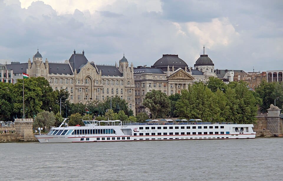
The Danube River is Europe’s second-longest river and one of its most culturally significant waterways, flowing through ten countries and connecting some of the continent’s most beautiful cities. Cruise itineraries range from short regional routes to extensive journeys across Central and Eastern Europe.
Highlights include the imperial architecture of Vienna, the charming old town of Bratislava, and the magnificent riverside setting of Budapest. Other memorable sections include Austria’s scenic Wachau Valley and the dramatic Iron Gates Gorge between Serbia and Romania.
The Danube offers a remarkable blend of history, architecture, music, cuisine, and natural beauty. Few rivers provide such diversity within a single journey, making it one of Europe’s most popular and rewarding cruise destinations.
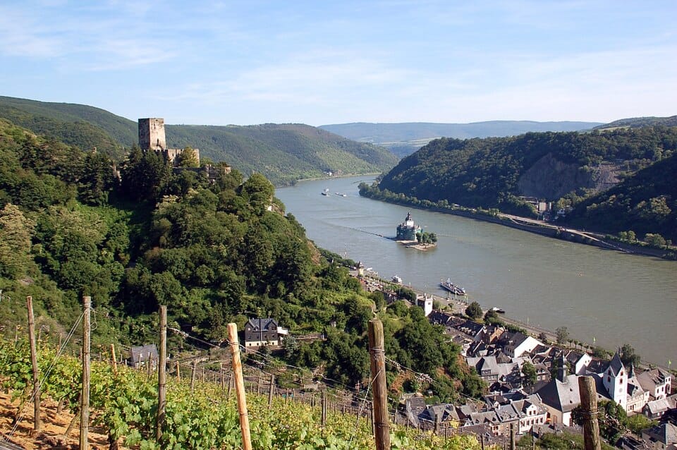
The Rhine Gorge is one of Europe’s most iconic river journeys, following a scenic stretch of the Rhine River between Bingen and Koblenz. Despite its relatively short length, it contains one of the highest concentrations of castles found anywhere in the world.
Steep vineyard-covered slopes rise above the river, crowned by medieval fortresses, watchtowers, and historic villages. The most famous landmark is the legendary Lorelei Rock, associated with centuries of folklore and river myths.
The scenery is exceptionally dense, with new castles, vineyards, and picturesque settlements appearing around almost every bend. For travellers seeking a classic European river landscape filled with history and romance, the Rhine Gorge remains one of the continent’s most celebrated cruise routes.
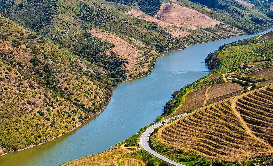
The Douro River cruise travels through northern Portugal‘s most famous wine-producing region, a UNESCO World Heritage landscape shaped by centuries of viticulture. The river winds through steep valleys lined with terraced vineyards that create some of Europe’s most beautiful rural scenery.
Most itineraries operate between Porto and the Spanish border, passing traditional wine estates, historic villages, and dramatic hillsides covered with grapevines. Many cruises include visits to renowned Port wine producers where travellers can learn about local traditions and sample some of Portugal’s most famous wines.
The combination of river scenery, gastronomy, and cultural heritage makes the Douro distinctly different from many other European river cruises, offering a slower and more intimate experience.
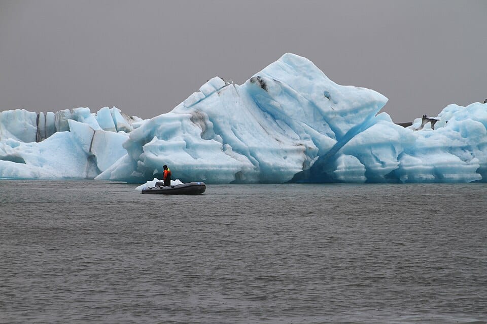
The Jökulsárlón Glacier Lagoon boat tour offers one of the most extraordinary water-based experiences in Iceland. Located at the edge of Vatnajökull National Park, the lagoon is filled with icebergs that have broken away from the Breiðamerkurjökull Glacier, creating a constantly changing landscape of floating ice.
Visitors travel among icebergs that range from small crystal-clear fragments to towering blue-white blocks sculpted by wind, water, and time. The contrast between the ice, black volcanic sands, and surrounding mountains creates one of Iceland’s most photographed landscapes. Seals are frequently spotted swimming between the icebergs or resting on floating ice, while the glacier itself provides a spectacular backdrop throughout the journey.
Although relatively short, the experience offers a rare opportunity to navigate through an active glacial environment and witness the effects of nature’s forces up close.
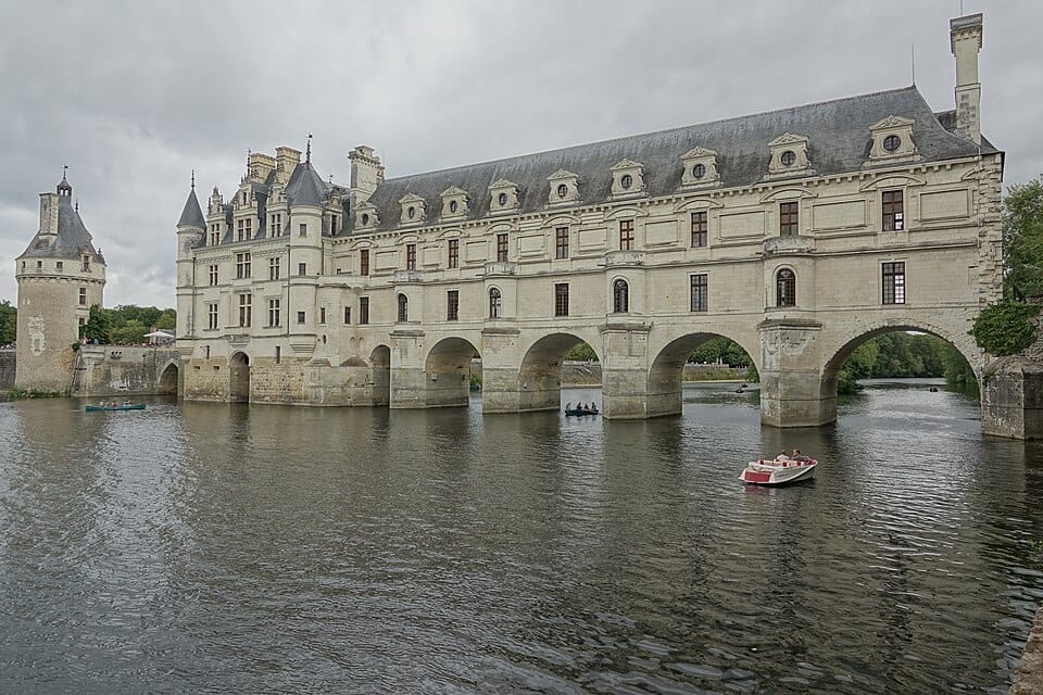
The Loire Valley offers a refined and culturally rich cruising experience through one of France‘s most celebrated regions. Often called the “Garden of France,” the valley is famous for its vineyards, historic towns, and magnificent Renaissance castles.
Cruises along sections of the Loire River provide access to architectural masterpieces such as Château de Chambord, Château de Chenonceau, and numerous other castles that reflect the wealth and influence of French royalty.
The surrounding landscape consists of rolling countryside, forests, vineyards, and charming villages that seem frozen in time. For travellers interested in history, wine, architecture, and French culture, the Loire Valley provides one of Europe’s most elegant inland cruise experiences.
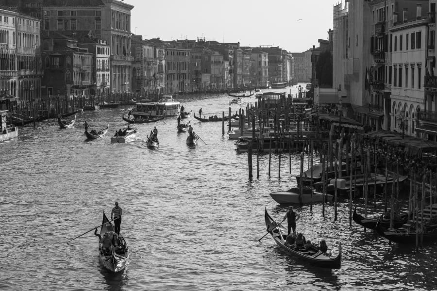
A cruise through the canals of Venice offers one of the most unique urban boating experiences in Italy. Built across more than 100 small islands connected by waterways and bridges, Venice has relied on water transport for centuries.
The journey typically follows sections of the famous Grand Canal, passing magnificent palaces, historic churches, elegant bridges, and centuries-old waterfront buildings. Architectural styles range from Byzantine and Gothic to Renaissance and Baroque, reflecting the city’s long history as a maritime power.
Beyond the famous landmarks, smaller canals reveal quieter neighbourhoods where local life continues much as it has for generations. The combination of history, architecture, and atmosphere makes Venice one of the world’s most distinctive cruise experiences.
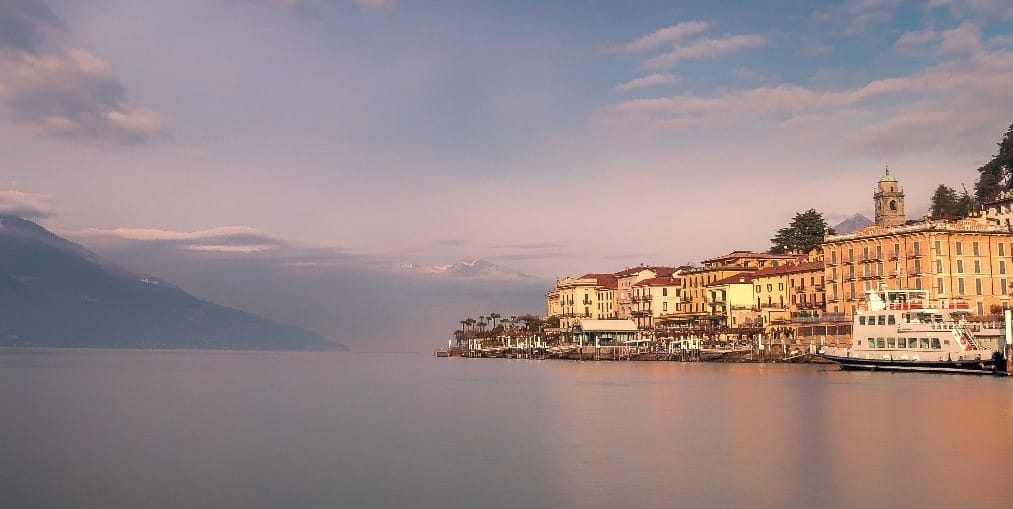
Nestled among the foothills of the Alps, Lake Como is one of Europe’s most elegant and scenic cruise destinations. The lake’s distinctive Y-shape creates a variety of routes linking picturesque towns, historic villas, and spectacular mountain scenery.
Cruises commonly visit Bellagio, Varenna, and Como, each offering a unique blend of lakeside charm, colourful architecture, and cultural heritage. Along the shoreline, visitors can admire grand villas surrounded by beautifully maintained gardens that have attracted aristocrats, artists, and celebrities for centuries.
The surrounding mountains provide a dramatic backdrop, particularly during clear summer days. Combining natural beauty, history, and refined Italian atmosphere, Lake Como delivers a cruising experience that feels both relaxing and sophisticated (and a bit posh!).
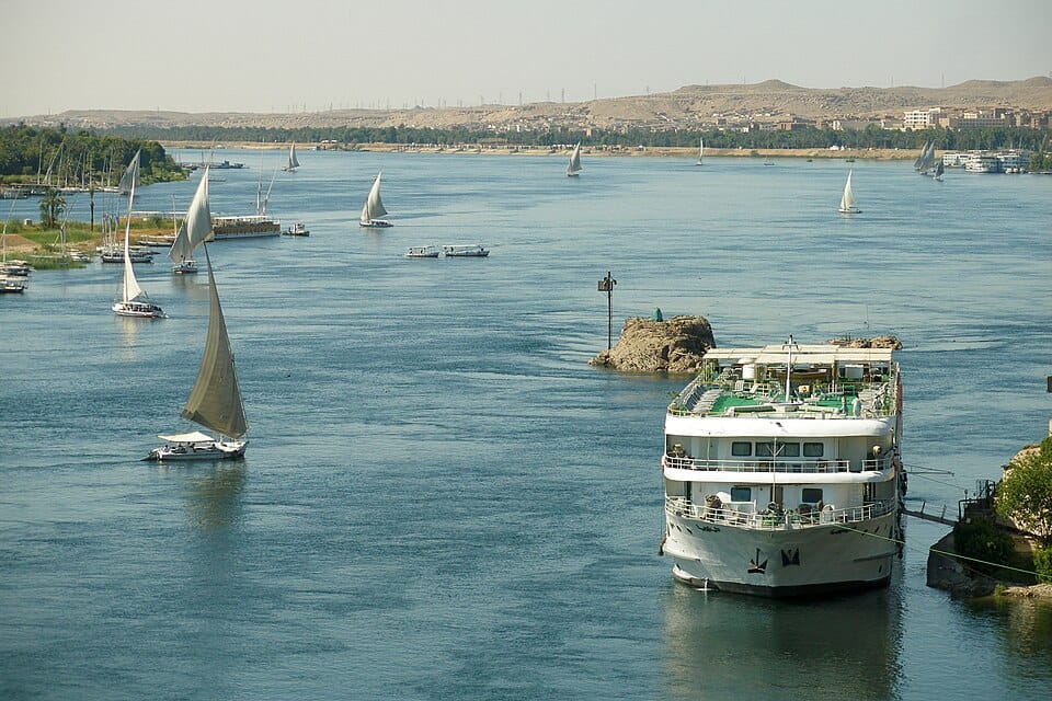
The Nile River cruise is one of the world’s most iconic travel experiences, following the waterway that sustained ancient Egyptian civilisation for thousands of years. Most cruises operate between Luxor and Aswan, linking an extraordinary concentration of archaeological treasures along a relatively short stretch of river.
Highlights include Karnak Temple, Luxor Temple, the Valley of the Kings, Temple of Edfu, Kom Ombo Temple, and Philae Temple. Between sightseeing stops, passengers enjoy views of traditional villages, palm groves, fertile farmland, and desert landscapes that have remained largely unchanged since antiquity.
Unlike many cruises that focus primarily on entertainment, the Nile offers a journey through one of the greatest open-air museums in the world, where almost every stop reveals another chapter of human history.
The Chobe River Cruise is widely regarded as one of Africa’s finest wildlife boat safaris. Located along the border between Botswana and Namibia, the river supports extraordinary concentrations of animals, particularly during the dry season when wildlife gathers near permanent water sources.
The cruise is best known for its enormous elephant population, with herds often seen swimming, drinking, and crossing the river. Hippos, crocodiles, buffalo, antelope, and numerous bird species are also frequently encountered. The riverbanks are constantly active, offering wildlife viewing opportunities throughout the journey.
Unlike traditional game drives, boats allow visitors to approach animals quietly and from a different perspective. Sunset departures are especially popular, as the warm African light reflects across the water while animals become increasingly active along the shoreline.
The Okavango Deltais one of Africa’s most remarkable natural wonders, a vast inland delta where seasonal floodwaters spread across the Kalahari Desert, creating a network of lagoons, channels, and islands. Unlike motorised river cruises, this experience takes place aboard traditional mokoro canoes.
Guided by skilled local polers, visitors glide silently through narrow waterways lined with papyrus reeds and water lilies. The absence of engines creates a unique connection with nature, allowing close encounters with elephants, antelope, hippos, crocodiles, and a remarkable variety of birdlife.
The peaceful atmosphere and untouched scenery make the Okavango one of Africa’s most authentic wilderness experiences. Few destinations offer such a quiet and intimate way to experience wildlife in its natural environment.
The Zambezi River cruise near Victoria Falls combines spectacular scenery with exceptional wildlife viewing. While not offering direct views of the waterfalls, the calmer sections of the river upstream provide a perfect setting for leisurely cruises through protected wilderness.
Passengers frequently observe hippos, crocodiles, elephants, buffalo, and numerous bird species gathering along the riverbanks. The broad channels and small islands create beautiful landscapes that constantly change throughout the day.
Sunset cruises are particularly memorable, with golden skies reflecting across the water while wildlife becomes more active during the cooler evening hours. The combination of scenery, wildlife, and proximity to Victoria Falls makes this one of southern Africa’s most rewarding short cruise experiences.
The Mississippi River is one of the most iconic waterways in North America, flowing through the heart of the United States and shaping the country’s history, commerce, and culture. Cruises often focus on sections between New Orleans, Memphis, and St. Louis.
Along the (expensive) journey, travellers encounter historic river towns, Civil War landmarks, plantation estates, and locations deeply connected to the development of blues, jazz, and rock ‘n’ roll music. Traditional paddlewheel-style vessels often enhance the nostalgic atmosphere.
The Mississippi offers a unique perspective on American history and culture, combining scenic river landscapes with stories of exploration, trade, music, and social change that helped shape the nation. It remains one of the most culturally significant cruises in the world.
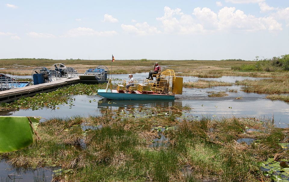
The Everglades experience is very different from a traditional cruise, but it remains one of the world’s most distinctive boat journeys. High-powered airboats travel across vast wetlands in southern Florida, allowing access to shallow waters inaccessible to conventional vessels.
The landscape consists of sawgrass marshes, mangrove forests, freshwater channels, and wetlands that support an extraordinary variety of wildlife. Visitors frequently encounter alligators, turtles, snakes, wading birds, and numerous fish species.
The speed and manoeuvrability of the boats add excitement to the experience, while knowledgeable guides explain the ecological importance of this fragile environment. It offers an entirely different perspective on wildlife exploration compared with traditional river and coastal cruises.
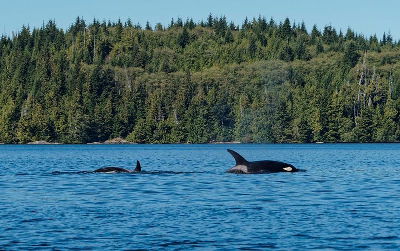
Located between Washington State and Canada, the San Juan Islands offer some of the best whale-watching opportunities in North America. Cruises operate through a scenic archipelago of forested islands, rocky shorelines, and protected waterways.
The main attraction is the chance to observe orca whales in their natural habitat, although humpback whales, minke whales, harbour seals, sea lions, and bald eagles are also frequently seen. The surrounding scenery is equally impressive, with mountain views extending toward both the Olympic Mountains and the Canadian coastline.
Because the waters are relatively calm and wildlife sightings are common, the San Juan Islands have become one of the most respected marine wildlife cruise destinations in the world.
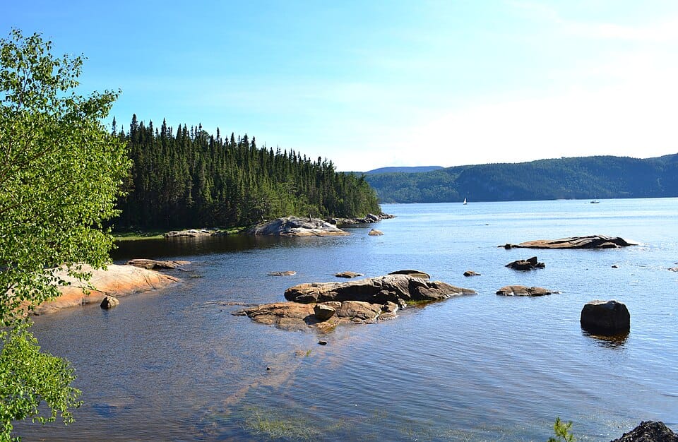
The Saint Lawrence River links the Great Lakes to the Atlantic Ocean and offers one of North America’s most varied cruise experiences. Depending on the route, travellers can explore historic cities, remote islands, and marine wildlife habitats.
Popular itineraries include the picturesque Thousand Islands region and the historic streets of Quebec City, one of the oldest European settlements in North America. Further downstream, cruises may enter the spectacular Saguenay Fjord, where nutrient-rich waters attract beluga whales, minke whales, and other marine species.
The combination of French and British heritage, dramatic scenery, and excellent whale-watching opportunities makes the Saint Lawrence one of Canada’s most rewarding waterways and a unique cultural journey.
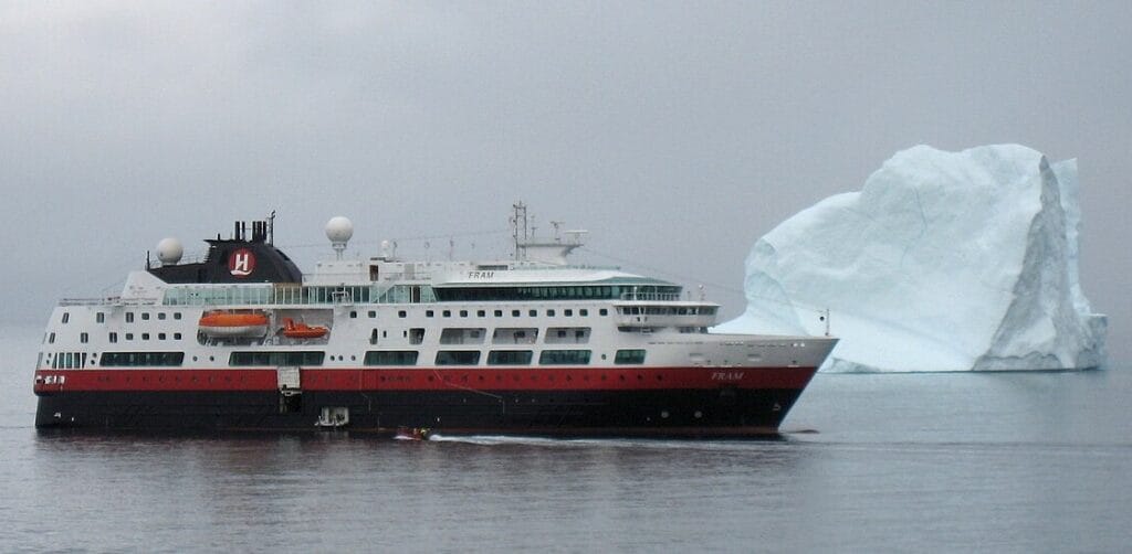
Although geographically closer to North America, Greenland deserves a category of its own due to its unique Arctic character. Expedition cruises explore immense fjords, towering icebergs, and glaciers that rank among the largest outside Antarctica.
The journey often includes visits to remote Inuit communities where traditional lifestyles continue despite the challenging environment. Wildlife sightings may include whales, seals, musk oxen, Arctic foxes, and countless seabirds.
The sheer scale of Greenland’s scenery is its defining feature. Massive ice formations drift through silent fjords while colourful settlements cling to rocky coastlines. For travellers seeking dramatic Arctic landscapes without venturing as far south as Antarctica, Greenland offers one of the world’s most spectacular expedition cruise experiences.
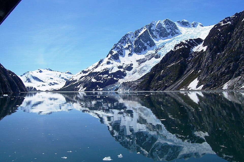
The Kenai Fjords Cruise explores one of Alaska’s most spectacular coastal wilderness areas, departing mainly from Seward and navigating deep fjords carved by ancient glaciers. The scenery combines snow-covered mountains, tidewater glaciers, and dramatic coastal cliffs that plunge directly into the sea.
Wildlife is a major highlight, with frequent sightings of humpback whales, orcas, sea otters, Steller sea lions, puffins, and bald eagles. Many cruises approach active glaciers where visitors can witness massive chunks of ice calving into the ocean.
The combination of glacier landscapes and abundant marine life makes Kenai Fjords one of the finest day-cruise experiences in North America and an excellent introduction to Alaska‘s wilderness.
The Inside Passage follows a protected network of channels stretching along the coasts of southeastern Alaska and British Columbia. Surrounded by mountains, forests, glaciers, and remote islands, it is widely considered one of the world’s most scenic coastal voyages.
Unlike open-ocean routes, much of the journey takes place in sheltered waters, allowing ships to travel close to the coastline. Highlights include glacier viewing, historic frontier towns, Indigenous cultural sites, and abundant wildlife such as whales, bears, sea lions, and bald eagles.
The constantly changing scenery and frequent wildlife encounters make the Inside Passage one of the most complete nature-focused cruises available anywhere in the world.
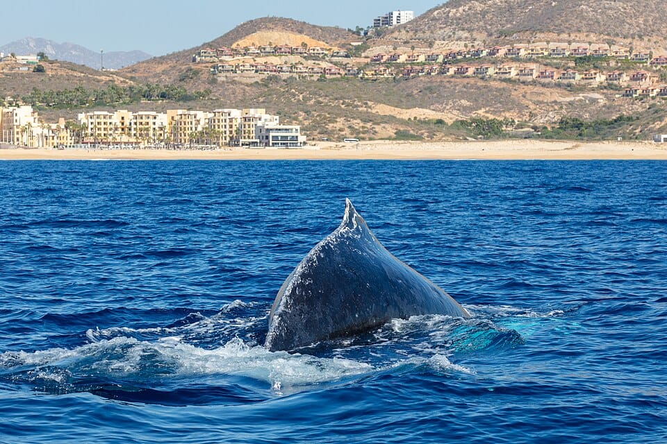
The Baja California Whale Cruise explores the waters surrounding Mexico‘s long Pacific peninsula, one of the world’s greatest whale migration corridors. Every winter, thousands of gray whales travel from Alaska to the sheltered lagoons of Baja California to breed and give birth.
Cruises often include close encounters with gray whales, humpback whales, blue whales, dolphins, and sea lions. In some locations, gray whales become surprisingly curious and may approach small boats voluntarily, creating unforgettable wildlife experiences.
Combined with desert landscapes, rugged coastlines, and rich marine ecosystems, Baja California offers one of the most accessible and reliable whale-watching cruises on Earth.
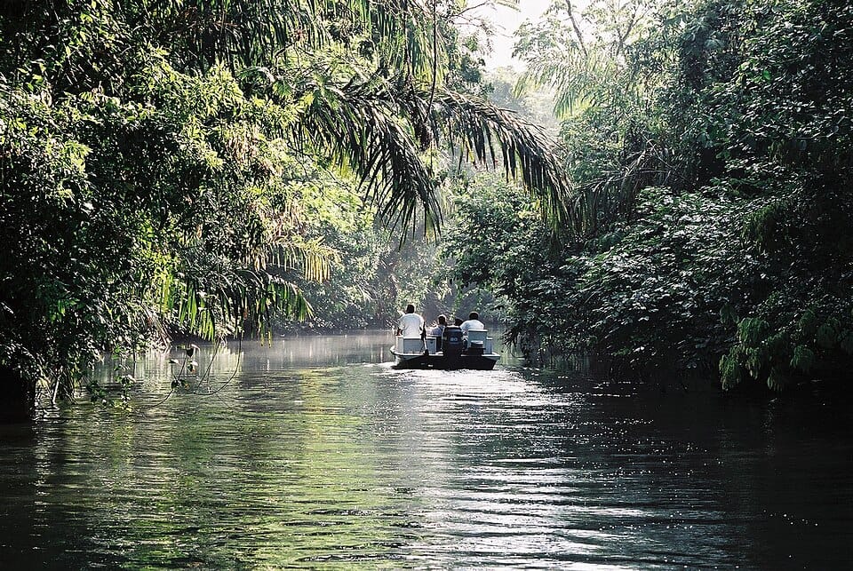
The Tortuguero Canal Cruise explores a vast network of waterways running through one of Costa Rica‘s most important rainforest regions. Often called the “Amazon of Central America,” the area is accessible mainly by boat and offers exceptional wildlife viewing opportunities.
Cruises navigate narrow jungle canals lined with dense tropical vegetation where monkeys, sloths, caimans, iguanas, toucans, and colourful frogs are frequently observed. The region is also famous for sea turtles, which nest on nearby beaches during certain times of the year.
The combination of rainforest scenery, rich biodiversity, and the feeling of travelling through an untouched wilderness makes Tortuguero one of Central America’s most rewarding boat journeys.
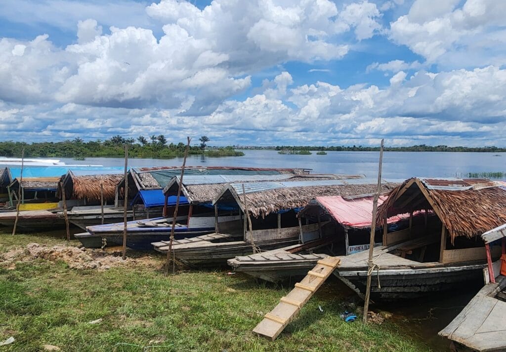
The Amazon cruise around Iquitos offers one of the most immersive rainforest experiences on the planet. Located deep within the Peruvian Amazon, Iquitos is famously one of the largest cities in the world inaccessible by road, making it a natural gateway to the upper Amazon Basin.
Cruises explore sections of the Amazon, Marañón, Ucayali, and Napo rivers, passing through flooded forests, remote villages, and some of the richest wildlife habitats on Earth. Sightings commonly include pink river dolphins, sloths, monkeys, caimans, macaws, toucans, and countless other species.
Many itineraries include guided excursions by small skiff, allowing visitors to reach narrow tributaries inaccessible to larger vessels. The journey offers an exceptional combination of wildlife observation, local culture, and exploration of the world’s largest rainforest ecosystem.
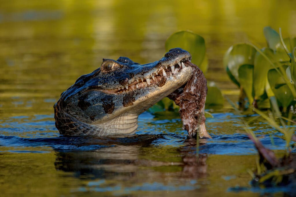
The Pantanal River Cruise explores the world’s largest tropical wetland, a vast ecosystem stretching across western Brazil and into neighbouring Bolivia and Paraguay. Unlike the dense vegetation of the Amazon, the Pantanal consists largely of open floodplains, making wildlife considerably easier to observe.
Cruises navigate slow-moving rivers and seasonal waterways that support one of South America’s richest concentrations of animal life. Jaguars are the primary attraction, often seen resting or hunting along riverbanks. Other species include giant river otters, capybaras, caimans, tapirs, anteaters, and hundreds of bird species.
Wildlife viewing is particularly rewarding at sunrise and sunset when animal activity peaks. For photographers and nature enthusiasts, few destinations offer such reliable opportunities for close wildlife encounters.
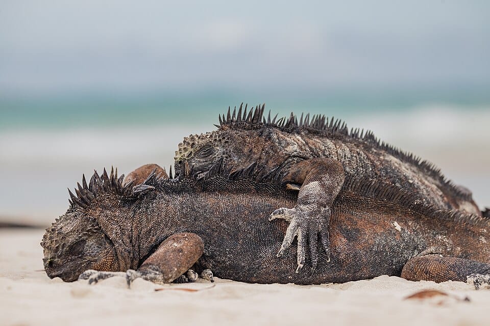
A Galápagos Islands cruise is widely considered one of the finest wildlife experiences on Earth. Located approximately 1,000 kilometres west of Ecuador, the archipelago inspired many of Charles Darwin’s observations that contributed to the theory of evolution.
Each island offers unique landscapes and wildlife, ranging from volcanic lava fields and cactus-covered terrain to white-sand beaches and mangrove forests. Visitors can encounter giant tortoises, marine iguanas, sea lions, blue-footed boobies, penguins, and numerous endemic species found nowhere else in the world.
Strict conservation measures help preserve the fragile ecosystem while expedition cruises provide access to multiple islands. The result is a journey unlike any other, combining extraordinary biodiversity with spectacular volcanic scenery.
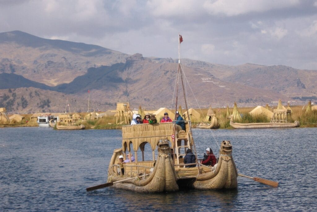
Situated at over 3,800 metres above sea level, Lake Titicaca is the highest navigable lake in the world and one of South America’s most culturally significant destinations. Cruises explore the vast lake shared by Peru and Bolivia, surrounded by snow-capped Andean peaks.
Highlights include visits to the famous Uros Floating Islands, constructed entirely from reeds, and Taquile Island, known for its traditional weaving culture. The lake also holds an important place in Inca mythology, being regarded as the birthplace of the Sun God.
The combination of stunning mountain scenery, indigenous culture, and unique floating communities makes Lake Titicaca one of the most distinctive boat journeys in the world.
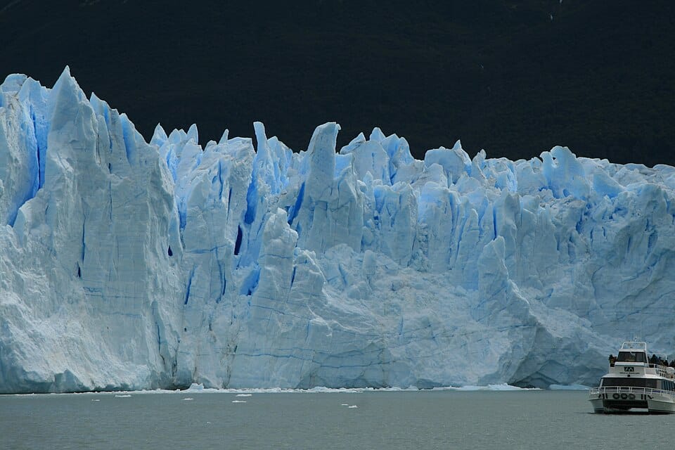
The Perito Moreno Glacier Cruise offers one of the most spectacular glacier experiences in the world, taking visitors across the icy waters of Lake Argentino in Los Glaciares National Park, Patagonia. Unlike many glaciers that are retreating, Perito Moreno remains one of the few major glaciers on Earth that is still advancing, creating a constantly changing landscape of towering ice walls.
Cruise vessels navigate close to the glacier’s massive face, which stretches for approximately 5 kilometres and rises up to 70 metres above the water. One of the highlights is witnessing huge blocks of ice break away from the glacier and crash into the lake, a dramatic natural phenomenon known as calving. The surrounding scenery includes snow-capped peaks, ancient forests, and floating icebergs that create exceptional photographic opportunities.
The combination of accessibility, scale, and active glacier dynamics makes the Perito Moreno cruise one of South America’s most unforgettable water-based experiences.
The Kimberley region of northwestern Australia is one of the country’s last true wilderness areas. Expedition cruises explore a remote coastline of cliffs, islands, waterfalls, gorges, and beaches that remain largely inaccessible by road.
Highlights include the famous Horizontal Falls, the towering cliffs of King George Gorge, ancient Aboriginal rock art sites, and powerful tidal systems that dramatically shape the landscape. Wildlife sightings often include saltwater crocodiles, dolphins, sea turtles, and numerous seabirds.
The combination of geological wonders, Indigenous heritage, and extreme remoteness makes the Kimberley one of the most unique expedition cruise destinations in the Southern Hemisphere and a true adventure for travellers seeking untouched landscapes.
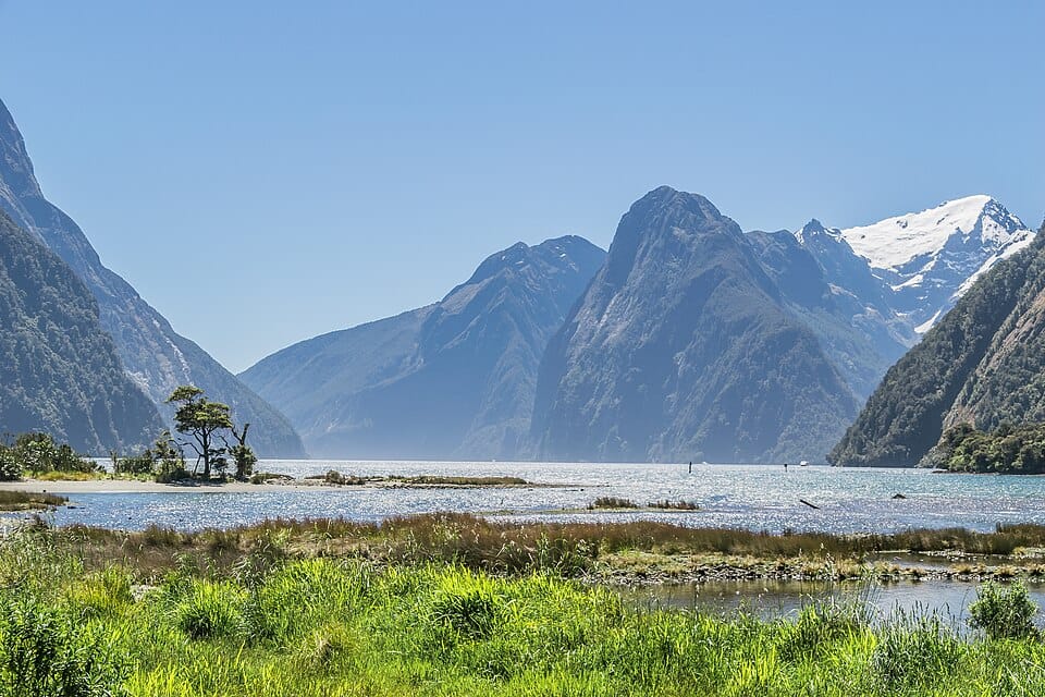
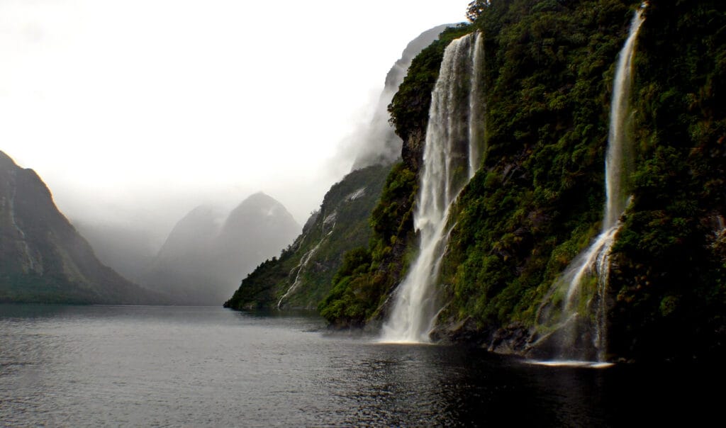
Often described as the most beautiful fjord in New Zealand, Milford Sound offers a spectacular cruise through a landscape of towering cliffs, rainforest-covered mountains, and cascading waterfalls. Located within Fiordland National Park, it is one of the country’s most famous natural attractions.
The fjord was carved by glaciers during the Ice Age, creating dramatic rock walls that rise almost vertically from the water. Wildlife commonly observed includes dolphins, New Zealand fur seals, and occasionally penguins.
Frequent rainfall enhances the scenery by creating hundreds of temporary waterfalls that cascade down the cliffs after storms. Despite its relatively short length, Milford Sound delivers some of the most dramatic scenery found anywhere in the world.
Larger and more remote than Milford Sound, Doubtful Sound offers a quieter and more immersive fjord experience. Access requires crossing Lake Manapouri and travelling over a mountain pass, naturally limiting visitor numbers.
The fjord stretches deep into the mountains of Fiordland National Park, surrounded by dense rainforest, waterfalls, and rugged peaks. Wildlife often includes bottlenose dolphins, fur seals, and the rare Fiordland crested penguin.
One of the most memorable moments on many cruises occurs when engines are stopped entirely, allowing passengers to experience the profound silence of the wilderness. This sense of isolation makes Doubtful Sound a favourite among travellers seeking a less crowded alternative to Milford Sound.
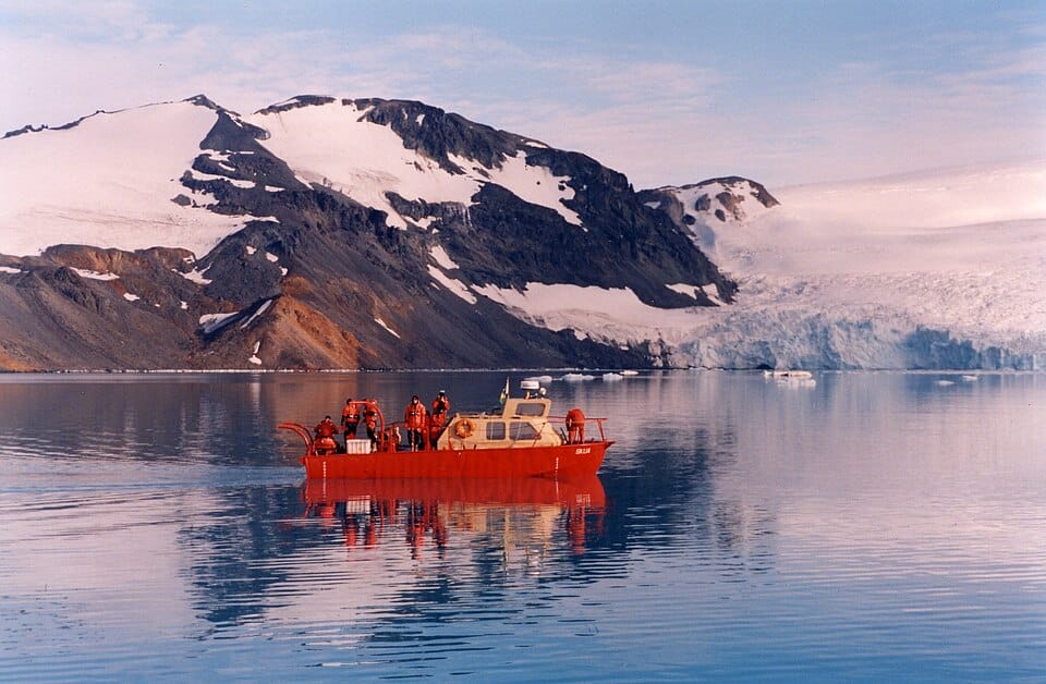
An expedition cruise to Antarctica is one of the most extraordinary journeys available to modern travellers. Most voyages depart from the southern tip of South America and cross the legendary Drake Passage before reaching the Antarctic Peninsula.
The scenery is unlike anywhere else on Earth. Towering icebergs, immense glaciers, snow-covered mountains, and frozen bays create a landscape that feels almost otherworldly. Wildlife encounters are equally impressive, with penguin colonies, seals, whales, and seabirds commonly observed throughout the voyage.
Most itineraries include zodiac landings, allowing passengers to step onto the Antarctic continent and explore remote locations inaccessible to larger vessels. The combination of isolation, wildlife, and pristine natural beauty makes Antarctica one of the ultimate cruise destinations.
Best time: November to March
This website uses cookies to improve your experience. We'll assume you're ok with this, but you can opt-out if you wish. Cookie settingsACCEPT
Privacy & Cookies Policy
Privacy Overview
This website uses cookies to improve your experience while you navigate through the website. Out of these cookies, the cookies that are categorized as necessary are stored on your browser as they are essential for the working of basic functionalities of the website. We also use third-party cookies that help us analyze and understand how you use this website. These cookies will be stored in your browser only with your consent. You also have the option to opt-out of these cookies. But opting out of some of these cookies may have an effect on your browsing experience.
Necessary cookies are absolutely essential for the website to function properly. This category only includes cookies that ensures basic functionalities and security features of the website. These cookies do not store any personal information.
Any cookies that may not be particularly necessary for the website to function and is used specifically to collect user personal data via analytics, ads, other embedded contents are termed as non-necessary cookies. It is mandatory to procure user consent prior to running these cookies on your website.


.jpg)
.jpg)
.jpg)
_003.jpg)
.jpg)
_(1).jpg)
.jpg)
,_Cabo_San_Lucas,_M%C3%A9xico,_2024-12-22,_DD_09.jpg)
_-_16.jpg)
.jpg)
_(52832205584).jpg)