If you have been yearning for an escape to Italy but can’t decide whether Rome or Venice is right for your retreat, we understand how tough the decision can be. Both these Italian cities are iconic in their own way. Even though these cities promise unforgettable experiences, they appeal to different kinds of travellers. So, if you are torn between Rome and Venice for acity break, you have come to the right place. Let’s tell you everything about these beautiful cities to help you decide which one will be perfect for your next Italian city break.
As you might already know, Rome is ideal for history lovers, food enthusiasts, and visitors who want to explore famous landmarks. At the same time, Venice suits travellers looking for romance, beautiful scenery, canals, and a slower pace. For a short holiday, your choice may come down to what you want to see, how much you want to spend, and how you prefer to travel around a city. Here is a comprehensive Rome vs Venice city break guide that compares the two destinations to help you decide.
Rome vs Venice: Quick Comparison
Category
Rome
Venice
Best for
History, culture, food, and sightseeing
Romance, canals, architecture and atmosphere
Ideal stay
3-5 days
2-3 days
Famous attractions
Colosseum, Vatican City, Trevi Fountain
St Mark’s Square, Rialto Bridge, Doge’s Palace
Getting around
Metro, buses and walking
Walking and water buses
Food
Excellent variety and traditional Roman dishes
Seafood, cicchetti and Venetian specialities
Atmosphere
Energetic and lively
Romantic and atmospheric
Families
Excellent
Good, although bridges and walking can be challenging
Budget
Wide range of options
Can be expensive, especially in central areas
Best for first-time Italy trip
Excellent
Excellent for a shorter break
Rome: The History and Culture Hub of Italy
Rome is one of the world’s most iconic historic and cultural destinations. The city combines ancient ruins, Renaissance art, Baroque architecture, and modern Italian life in one destination. The Colosseum, Roman Forum, and Pantheon provide a glimpse into ancient Rome, while Vatican City offers attractions such as St. Peter’s Basilica and the Vatican Museums.
There is nothing like spending the afternoon exploring neighborhoods, sitting in a piazza with an espresso, or trying traditional Roman dishes such as carbonara, cacio e pepe, and amatriciana.
Why Should You Choose Rome?
Rome is particularly appealing if you want:
Major historical attractions
Museums and art galleries
Traditional Italian food
A wider choice of hotels and restaurants
Vibrant nightlife
More activities for a longer city break
Easy access to other Italian destinations
One reason UK travellers plan holidays to Rome is the variety it offers. You can spend the morning exploring ancient ruins, visit an art museum in the afternoon, and enjoy dinner in a local trattoria in the evening. This variety of Rome is what tourists enjoy.
Venice: Perfect for Romance and Atmosphere
Venice’s romantic, atmospheric vibes attract thousands of travellers from around the world. Built across a lagoon, Venice is famous for its canals, bridges, historic buildings, and distinctive atmosphere. You get a truly unique experience you might not find anywhere else.
The Grand Canal, St. Mark’s Square, Doge’s Palace, and Rialto Bridge are among its most recognisable sights. Instead of relying heavily on cars or conventional public transport, many visitors explore the historic center on foot or by water bus.
You will have an unforgettable time in Venice, but you’ll need to wander away from the famous tourist attractions. Small squares, quiet canals, traditional cafés, and historic alleyways can make even an unplanned walk feel like part of the holiday.
Why Should You Choose Venice?
Venice is a great option if you want:
A romantic city break
Beautiful architecture and scenery
Gondola rides and canal views
A compact historic center
Photography opportunities
A slower and more atmospheric experience
A memorable destination for couples
If these are the things that you are looking for in your next Italian city break, it is time that you start planning Venice holidaysfrom the UK.
Rome vs Venice: Attractions
If sightseeing is one of your main concerns, you might want to know which city has better attractions. The best city for you depends on the type of attractions you enjoy.
Venice wins for visual experiences and unique landmarks. The canals, bridges, palaces, and lagoon setting make the entire city feel like an attraction.
If you are visiting Italy for the first time and want to see some of the country’s most famous historical sites, choose Rome. If you have already experienced major European capitals and want something more distinctive, Venice could be the better option.
Rome vs Venice: Food
Italy is known for its food, so you can expect delicious food in both Rome and Venice. Rome is particularly known for hearty pasta dishes. Look out for carbonara, cacio e pepe, amatriciana, and gricia, alongside Roman-style pizza and supplì.
Venice has a stronger connection to seafood and small sharing dishes. Cicchetti, small snacks served in traditional bacari, are a great way to experience local food. Seafood, risotto, and dishes influenced by the city’s lagoon setting are also worth trying.
Which Has Better Food?
For overall variety, Rome has the advantage. Its larger size means you can find everything from inexpensive pizzerias to sophisticated restaurants.
However, Venice is hard to beat if you want a distinctive local food experience.
Rome vs Venice: Better Option for Couples
If you are planning a romantic getaway with your partner, nothing can top Venice. Venice is one of the world’s most romantic destinations. A gondola ride, evening walk beside a quiet canal, or dinner overlooking the water can create a naturally romantic atmosphere. The city’s compact streets also make it easy to spend a day exploring without following a strict itinerary.
But this doesn’t mean that Rome is completely out of the picture. Rome is romantic too, particularly around its fountains, piazzas, and historic streets. Couples can enjoy sunset views, rooftop restaurants, and leisurely dinners.
Choose Venice for romance and atmosphere, and Rome for romance combined with sightseeing, food, and nightlife.
Summing Up
Whether you want a Rome or Venice holiday depends on your preferences and what you want from an Italian escape. Both cities offer exceptional experiences that travellers enjoy. But these experiences might be quite different. So, before you decide, choose the experience you want for your next Italian city escape.
Jeddah has changed considerably over the years, but walking beside the Red Sea in the evening is still one of the simplest ways to experience the city.
The Jeddah Corniche stretches for more than 30 kilometres along the coast, with walking areas, parks, children’s spaces, public art, food stalls and places where families gather beside the water. Official Saudi tourism information describes it as one of the city’s major waterfront destinations, but the part that is harder to explain in a travel guide is the rhythm of the place after sunset.
I have visited corniches in other countries, including Morocco and Pakistan, and each has its own character. But Jeddah’s waterfront has always felt different to me. I may be biased because Jeddah was home, but the combination of the Red Sea, families walking late into the evening, food stalls, mosques and the interruption of the walk for prayer gives it a character I have not experienced in quite the same way elsewhere.
Why I prefer the Corniche in the evening
For a visitor, sunset and the hours after it are probably the easiest time to enjoy a long walk along the waterfront.
Jeddah can be very hot during the day. At night, the temperature is easier to manage, families come out, children play around the public areas and the waterfront becomes a place to walk rather than simply somewhere to see.
That does not mean you will not get thirsty.
Even during an evening walk, 15 or 20 minutes can be enough to make you want water, particularly when the weather is humid. Small stalls selling ice cream, fries, snacks and drinks are easy enough to find in busy parts of the Corniche. Water there may cost a little more than it would from a neighbourhood baqala, so if you know you will be walking for a while, I would simply carry a bottle with you.
During the daytime, that becomes even more important.
And one small request from somebody who loves the waterfront: once you finish the bottle, use the bins. It is easy for busy public spaces to collect litter, and keeping the coastline clean makes a noticeable difference to everyone using it.
Prayer is part of the rhythm of the Corniche
One thing I particularly appreciate about Jeddah’s Corniche is that a walk does not have to compete with prayer time.
There are mosques in different parts of the waterfront, so when the adhan comes in you can stop, make your prayer, sit for a little while in the air conditioning and then continue your walk.
That break changes the pace of the evening.
Instead of trying to fit everything into one uninterrupted outing, you can walk, stop for prayer, rest for a while, talk, and then go back outside.
And where a mosque is not immediately nearby, it is not unusual to see people gather, lay out prayer mats and form a jama’ah when prayer time enters.
For me, that is one of the reasons an evening on the Jeddah waterfront feels calmer than simply walking through a conventional entertainment district.
Al Rahma Mosque: an unplanned stop that became part of the evening
One of my clearest memories of this was in 2018.
We were heading to the Corniche one evening when Maghrib time came in. Al Rahma Mosque was nearby, so we decided to stop there for prayer.
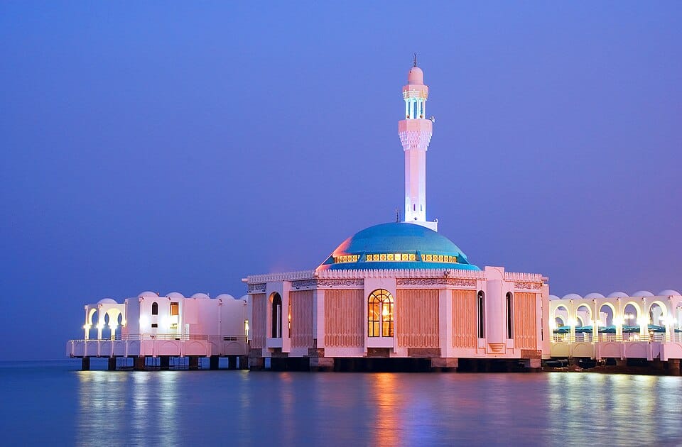
The mosque is one of Jeddah’s best-known landmarks and is often called the Floating Mosque because it stands over the Red Sea. It was built in 1985 and is connected to the mainland by a pathway. Its position over the water has made it both a functioning mosque and a well-known stop for visitors to Jeddah.
We had to park a little farther away than we expected, but I remember the walk toward the mosque being part of the experience rather than an inconvenience.
Children were playing nearby and the evening itself was quiet.
To reach the mosque, you cross the pathway over the water. We stopped a few times and looked down to see whether we could spot any fish beneath us. It was already dark and the water was not perfectly clear, but we could still make some out below.
Then we went inside for Maghrib.
What stayed with me most was not really the architecture. It was how peaceful the whole setting felt: the sea outside, the cooler interior of the mosque and the imam’s qira’ah during the prayer.
It turned what had simply been a stop because prayer time had arrived into one of the more memorable parts of the evening.
When I visited, bottled drinking water was available in refrigerators inside the mosque.
There was no one standing there distributing it. If you were thirsty, you could simply take a bottle, and there was no charge.
I always find something beautiful about that. Outside, you might find the same bottle of water being sold for a couple of riyals or more, while inside a mosque someone you may never meet has paid for it and left it there for anyone who needs a drink.
For me, little things like this are reminders to be grateful to Allah. Not everything has to be transactional. In Muslim culture, people regularly give water, food and other things hoping for reward from Allah in the akhirah, the afterlife, rather than expecting something back from the person receiving it.
Of course, I cannot say that bottled water will always be available at Al Rahma Mosque today. My visit was several years ago, and the brand or arrangements may have changed. But making drinking water freely available to worshippers is something you will come across in many mosques in Saudi Arabia.
If you are visiting the mosque during a longer Corniche walk, I would still carry your own water rather than assume it will be available.
What to bring for a Corniche walk
You do not need much, especially for an evening visit, but a few things make the experience more comfortable:
· comfortable walking shoes
· a bottle of water
· modest clothing, particularly if you expect to enter a mosque
· sunscreen and sun protection if you are visiting during daylight
· a little flexibility around prayer times
· a small bag or somewhere to keep your rubbish until you find a bin
For families, bringing your own water is even more useful because children may ask for drinks frequently once you start walking.
For an individual evening stroll, one bottle may be enough depending on the weather and how long you stay. For a family, group outing, school trip or event, it makes more sense to plan the quantity before leaving. For larger group requirements, Samar Water, a local supplier of bulk water cartons in Jeddah supplies bottled-water cartons in different brands and bottle sizes to homes, offices, schools, mosques, businesses and events across Jeddah.
That is particularly useful when one or two bottles bought individually from a stall turns into dozens of bottles for a group.
Don’t try to see the whole Corniche in one visit
Because the waterfront is so long, I would not approach Jeddah Corniche as something that needs to be “completed.”
Choose an area, walk for a while, stop when something catches your attention and allow the evening to develop naturally.
The official waterfront includes family spaces, play areas, public art and long walking routes, while other parts of the Jeddah coast offer different experiences altogether.
You can always come back another evening.
That is probably the best way to experience the Corniche anyway.
A quieter way to experience Jeddah
Visitors often build Jeddah itineraries around major landmarks, restaurants and shopping, and there is nothing wrong with that.
But an evening on the Corniche shows another side of the city.
Walk beside the Red Sea. Buy something small from one of the stalls. Watch the families and children around you. Stop when the adhan comes in. Pray if you are Muslim, take a break, drink some water, and then continue walking.
If Al Rahma Mosque is along your route, it is worth allowing enough time to stop rather than simply taking a photograph and leaving.
My own visit began only because Maghrib had arrived and we needed somewhere nearby to pray.
Years later, I still remember the walk over the water, looking down for fish, the cool interior of the mosque and the qira’ah during the prayer.
That is what I like about Jeddah’s Corniche: sometimes the most memorable part of the evening is the part you did not actually plan.
High above the valleys of central Nepal, enormous honeycombs hang from vertical cliffs where the rock seems to be impossible to reach. Twice a year, experienced honey hunters approach these colonies using handmade ladders, bamboo poles, ropes and their remarkable knowledge of the bees.
This is honey hunting in Nepal, one of the most extraordinary traditional practices in the Himalayas.
For centuries, the Gurung communities of Nepal have harvested wild honey from cliffs where the Himalayan giant honey bee (Apis laboriosa) builds its enormous exposed nests. The harvest is not simply a way of collecting honey. It is a seasonal event involving religious rituals, teamwork, inherited knowledge and a great dose of courage.
Today, honey hunting is also attracting travellers who want to witness one of Nepal’s most unusual cultural traditions. However, this is very different from a conventional tourist attraction. Visitors generally watch from a safe distance while experienced local hunters carry out the dangerous work.
The Himalayan giant honey bee, Apis laboriosa, is one of the largest honey bees in the world. Unlike domesticated bees, these wild bees cannot simply be kept in conventional hives. They construct large, exposed honeycombs on steep rock faces, often high above forested valleys.
The location of the colonies is one of the reasons honey hunting is so difficult. The bees choose cliffs that provide protection from predators and human access, leaving the honeycombs suspended in places where reaching them requires exceptional climbing skills.
The bees are also important to the Himalayan ecosystem. By moving between flowering plants while collecting nectar and pollen, they contribute to pollination across the mountain environment.
For the Gurung honey hunters, generations of observation have produced an intimate understanding of the bees. Hunters know the cliffs, recognise suitable colonies and understand when conditions are right for harvesting.
A Traditional Honey Hunt
The hunters arrive beneath a cliff carrying the equipment needed for the harvest. A long handmade ladder is secured from the top and suspended down the rock face. Smoke is then used to drive the bees away from the honeycombs and make the colony easier to approach.
The hunter descends the ladder towards the colony while members of the team remain above and below to provide support.
From this precarious position, the hunter uses long bamboo poles and traditional tools to reach the honeycomb. Sections of the comb are cut away and collected in baskets before being lowered back to the ground.
The hunter may be hanging tens of metres above the valley floor, surrounded by thousands of bees, with nothing resembling the safety equipment that would normally be expected for such a climb.
This is why honey hunting is not an activity for inexperienced visitors. The hunters who perform it have developed their skills over many years, and the technique is traditionally passed from one generation to another.
Honey hunting also has an important spiritual and communal side. Among Gurung communities, the harvest traditionally involves rituals and offerings intended to seek protection and a successful hunt. Food is prepared, equipment is transported to the site and different members of the community take on different responsibilities.
The exact customs vary between villages, but the important point is that the hunt is not simply an individual climbing expedition. It can be a major community event connecting people, tradition and the natural environment.
The Famous Mad Honey
Nepal’s cliff honey is sometimes associated with “mad honey”, a name that has attracted considerable attention from travellers and the international media.
The term refers to honey that contains grayanotoxins, naturally occurring compounds that can be present when bees collect nectar from certain plants, including some species of rhododendron.
Consuming sufficient quantities can cause dizziness, nausea, vomiting, weakness, sweating and changes in blood pressure or heart rate. The concentration of grayanotoxins can also vary, so “mad honey” should not be treated as an exotic recreational product.
The fascination with mad honey has sometimes overshadowed the much more interesting story behind it: the relationship between the bees, the Himalayan environment and the communities that have harvested wild honey for generations.
When and Where to See Honey Hunting
Honey hunting traditionally takes place during seasonal periods when the colonies contain sufficient honey. In many parts of Nepal, the main opportunities are associated with spring and autumn, although the exact timing depends on the location, weather, flowering conditions and local decisions.
One of the best-known areas is the Gandaki region of central Nepal, particularly parts of Kaski and Lamjung. Villages such as Bhujung, Ghanpokhara, Taghring, Mipra, Taapgaun, Chyamche, Ghermu, Dudhpokhari and Ghalegaun have been associated with traditional honey hunting.
Most visitors begin from Kathmandu or Pokhara. Pokhara is particularly convenient for exploring honey-hunting areas in the Gandaki region. From there, the journey usually continues by road towards rural communities, followed by hiking to the cliffs where the colonies are located.
The final approach can be considerably more demanding than the road journey suggests. Rural roads can be rough, while trails to the cliffs may involve steep terrain.
Because the harvest is controlled by local communities and depends on the natural cycle of the bees, arranging a visit through a local guide or community-based tourism operator is strongly recommended. A guide can establish whether a hunt is actually taking place and explain where visitors can safely observe it.
There is no guarantee of seeing an active harvest simply because you visit during the right season. Weather, bee populations and local decisions can all affect the timing.
A Tradition Under Pressure
Honey hunting is fascinating partly because it represents a relationship between people and the natural environment that has existed for generations. But that relationship is increasingly under pressure.
Research into Apis laboriosa populations in Nepal has documented declines in colonies and occupied cliffs, while honey-hunting communities have also reported falling yields.
Several factors may be contributing, including changes in climate, altered rainfall patterns, habitat loss, pesticides and other forms of human disturbance.
The decline matters for more than honey production. The bees are important pollinators, while honey hunting represents a body of traditional knowledge that can be difficult to replace once communities can no longer maintain the practice.
Responsible tourism can potentially help support these communities, but visitors should treat honey hunting as a cultural tradition rather than an extreme tourist attraction. Never attempt to climb the ladders or approach active colonies. The hunters are highly experienced, and the cliffs are genuinely dangerous.
Photography should also be carried out only with permission, particularly during religious ceremonies.
The most remarkable part of honey hunting is perhaps not the danger of the descent itself, but the knowledge behind it. The hunters understand the cliffs, the bees, the seasons and the surrounding environment in a way that has been built up over generations.
High above the valleys, enormous Apis laboriosa colonies continue their ancient cycle, while the Gurung communities continue a tradition that connects people directly with the Himalayan landscape.
For travellers looking for something genuinely unusual in Nepal, watching a traditional honey hunt from a safe distance can be one of the country’s most memorable experiences.
For many residents in towns such as Warrington, the real question is whether a bike is easy enough to use in normal daily life. Can it be stored safely? Can it be moved through a hallway or garden gate? Can it be pushed into an office or shed? Can it be lifted onto a car rack when needed? Does it feel manageable in traffic, at junctions and on shared paths?
These practical questions often decide whether someone cycles regularly or leaves the bike at home.
Electric bikes have already made cycling more accessible by reducing the effort needed for hills, headwinds and longer journeys. But some e-bikes are heavy. That extra weight may not matter much once the motor is assisting, but it matters a great deal when the rider has to move, store or handle the bike without power.
This is why lightweight e-bikes are becoming more relevant for everyday local travel.
They are not just a niche choice for performance riders. They can help commuters, flat residents, older returning cyclists, smaller riders and anyone who wants electric assistance without the bulk of a larger machine.
Why Weight Matters in Real Life
When people compare electric bikes, they often focus on motor power, battery range and price.
Those factors matter, but they do not tell the whole story. A bike can have a large battery and impressive specifications, yet still feel awkward if it is too heavy for the rider’s daily routine.
Weight affects the moments around the ride. It matters when taking the bike out of storage in the morning. It matters when pushing it through a narrow passage. It matters when lifting it over a kerb, parking it at work, moving it into a shed or securing it indoors. It also matters if the rider needs to combine cycling with a train, bus, car journey or office commute.
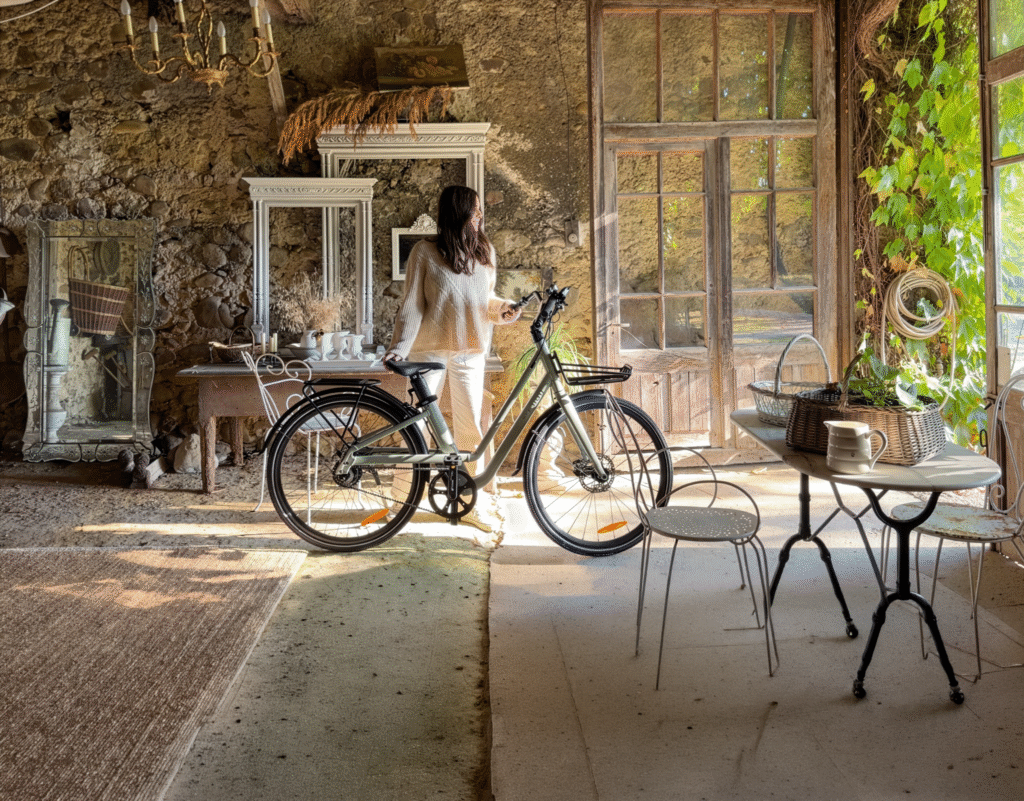
For residents who want electric assistance without the weight and bulk of a larger model, alightweight ebikecan make short local journeys easier to manage, store and repeat.
This is especially important for people who are trying to build a habit. A bike that feels easy to use is more likely to be used often. A bike that feels difficult to move may be used only occasionally, even if it rides well once on the road.
Lightweight E-Bikes and Local Journeys
Many journeys around Warrington are short enough for cycling.
The trip to work, the station, the shops, the town centre, a local appointment, the gym, a café or a friend’s house may only be a few miles. These are exactly the journeys where cycling can be practical, especially when traffic or parking makes driving less attractive.
However, ordinary cycling is not always realistic for everyone. Weather, wind, time pressure, work clothes, tiredness and small inclines can all discourage regular use. Electric assistance helps with these barriers.
A lightweight e-bike adds another layer of convenience.
It reduces the physical effort of riding while also reducing the handling burden of a heavier e-bike. That combination can make a local journey feel less like a commitment and more like a normal transport choice.
This matters because active travel succeeds when it fits into ordinary routines. People do not always change their travel habits because of one big decision. They change when the alternative becomes easy enough to repeat.
The Difference Between Riding Weight and Living Weight
An important distinction is the difference between riding weight and living weight.
Riding weight is how the bike feels when it is moving with assistance. A heavier e-bike can still feel smooth and easy once the motor is engaged.
Living weight is how the bike feels during everything else: lifting, pushing, parking, storing, manoeuvring and carrying out small daily tasks. This is where a lighter bike can make a significant difference.
A commuter may only ride for twenty minutes but handle the bike many times: taking it out, locking it, unlocking it, pushing it through a workplace entrance and storing it again at home. If those moments feel inconvenient, the rider may slowly stop using the bike.
For everyday cycling, living weight is just as important as riding performance.
Who Benefits Most From a Lighter E-Bike?
A lightweight e-bike can be useful for many types of riders.
Commuters benefit because a lighter bike is easier to handle before and after work. If secure cycle parking is limited, the option to bring the bike closer to a workplace or indoor space can be valuable.
Flat and terraced-house residents benefit because storage is often limited. Not everyone has a garage or wide garden access. A bike that is easier to move through tighter spaces may be much more practical.
Returning cyclists may also benefit. Someone who has not cycled regularly for years may feel more confident on a bike that is easier to control, push and park. Electric assistance helps with the ride itself, while lower weight helps with the overall experience.
Smaller riders can benefit too. This is not about creating a separate category for one group of people. It is about control. Riders of any age, height or strength may prefer a bike that feels manageable rather than intimidating.
Older riders may also value lighter handling. Many experienced cyclists want to keep riding for longer, but do not necessarily want a heavy e-bike that feels difficult to move when not riding. A lighter model can make everyday cycling feel more approachable.
Lightweight Does Not Mean Weak
A lightweight e-bike should not be judged only by the number on the scale.
The best lightweight design is not simply the lightest possible frame. It must still be strong, stable and safe. It needs reliable brakes, a sensible battery system, suitable tyres and a frame that can handle daily use.
This is where good design matters.
Reducing weight by removing useful features can make a bike less practical. A very light bike with poor comfort, limited range or weak braking is not a good everyday transport solution. A slightly heavier model with better components may be more useful for real riding.
The goal is balance.
A good lightweight e-bike should feel easy to handle without feeling fragile. It should be light enough to improve daily usability, but still strong enough for commuting, local roads and repeated use.
Battery Range and the Weight Trade-Off
Battery size is one of the main reasons e-bikes become heavy.
A larger battery can increase range, but it also adds weight. For some riders, that trade-off is worthwhile. Long-distance commuters or people who ride many miles each day may need the extra capacity.
For short local journeys, however, the biggest battery is not always necessary. A rider travelling a few miles each way may benefit more from lighter handling than from maximum range.
The right question is not “What is the largest battery available?” The better question is “How much range do I actually need, with a reasonable reserve?”
Weather, hills, rider weight, tyre pressure and assistance level all affect range. A practical e-bike should have enough capacity for the intended journeys, but not so much extra weight that the bike becomes difficult to live with.
This is one of the key decisions in lightweight e-bike design.
Brakes, Tyres and Road Conditions
A lighter e-bike still needs to perform safely on real roads.
Local riding can include wet surfaces, uneven tarmac, kerbs, shared paths, junctions and stop-start traffic. Good brakes are essential. An e-bike may travel faster than a normal bicycle in everyday use, and the rider must be able to slow down predictably.
Tyres matter as well. They affect grip, comfort and confidence. Narrow tyres may reduce rolling resistance, but wider or more stable tyres can be useful on rougher surfaces. The right choice depends on the route.
Lighting should also be considered. Commuters often ride in early mornings, evenings and darker winter conditions. Reliable front and rear lights are not optional extras for serious everyday use.
A lightweight e-bike should therefore be assessed as a complete vehicle, not just as a light frame with a motor.
Choosing an Electric Bike for the Real Journey
Choosing anelectric bike should start with the real journey: distance, storage, lifting, security, road conditions and how often the bike will be used.
A rider with a garage and a long commute may prefer a larger commuter e-bike with more range. A rider carrying children or heavy loads may need a cargo e-bike. A rider combining transport with rail, office storage or small living spaces may care more about compact size and weight.
For many people, the practical question is not whether an e-bike can complete one ride. It is whether the bike can support the same journey every day without becoming inconvenient.
This is where lightweight models can be valuable. They reduce friction around the ride. They make the bike easier to take out, easier to park, easier to store and easier to handle.
When a bike is easier to manage, it becomes easier to choose.
Fiido Air, C21 and C11 Pro as Examples of Different Lightweight Directions
Lightweight e-bikes are not all designed in the same way.
Fiido Air is an example of a more minimalist lightweight approach. Its design direction focuses on reducing weight, simplifying the frame and creating a clean urban riding experience. This kind of concept suits riders who value easy handling, modern design and a lighter daily ride.
Fiido C21 takes a slightly different route. It fits riders who want a lighter electric bike with a more versatile feel, suitable for commuting and mixed urban surfaces. For people who ride through town, parks or uneven local paths, that balance can be useful.
The Fiido C11 Pro is a lightweight electric bike with a removable battery that represents a different approach to lightweight design: comfort and everyday practicality. It fits more closely into the city commuter category, where the goal is not only to reduce weight, but also to provide a comfortable riding position, practical range and reliable performance for daily use.
These examples show that lightweight design is not one single formula. Some bikes focus on minimalism. Some focus on versatility. Others focus on comfort and commuting. The right choice depends on how the bike will actually be used.
Security and Storage Still Matter
A lighter bike may be easier to bring indoors, but security remains important.
Electric bikes are valuable, and riders should think carefully about where and how they are stored. A strong lock, secure parking habits and covered storage can make regular use more practical. If the battery is removable, storing it indoors may also help with charging and protection.
For many riders, security is closely linked to weight. A bike that can be moved indoors more easily may be less exposed to theft or weather. That can make ownership less stressful.
Storage is not just a small detail. It can decide whether someone rides daily or only occasionally.
When a Lightweight E-Bike Is Not the Best Choice
Lightweight e-bikes are useful, but they are not the answer for every rider.
If someone regularly carries heavy loads, a cargo bike may be more appropriate. If the route is long and demanding, a larger battery and more robust frame may be more useful. If maximum comfort on rough roads is the priority, a heavier bike with wider tyres or suspension may be better.
The point is not that lighter is always better.
The point is that weight should be considered honestly. If lifting, storing and handling the bike are major parts of the routine, lower weight can make a major difference. If those factors do not matter, another type of e-bike may be more suitable.
Lightweight E-Bikes and Everyday Active Travel
For towns such as Warrington, the future of local transport will not depend on one solution.
Cars will remain important for many journeys. Public transport will continue to serve key routes. Walking will always be the simplest option for very short distances. Cycling and e-bikes can fill the space between these choices.
Lightweight e-bikes can help because they make cycling more approachable. They are easier to handle than many heavier models and less demanding than traditional cycling over longer or windier routes. That makes them useful for people who want to reduce short car journeys without making daily travel more complicated.
This is the real value of lightweight electric mobility.
It does not ask every resident to become a serious cyclist. It simply makes everyday cycling easier to start and easier to repeat.
Conclusion: Easier Handling Can Lead to More Riding
A lightweight e-bike is not just about technical specifications.
It is about whether a bike fits into daily life.
For Warrington residents, that may mean commuting to work, riding to the town centre, connecting with public transport, storing the bike in a flat, moving it through a narrow space or choosing cycling for short local journeys that might otherwise be made by car.
The best lightweight e-bike is not necessarily the absolute lightest model available. It is the one that balances weight, safety, comfort, range and daily practicality.
When an e-bike is easier to lift, easier to store, easier to control and easier to use often, it becomes more than a transport product.
We all know that forests are vital to our lives, providing the air we breathe and housing over half of the world’s land-based wildlife. It is never enough to emphasize the issue of deforestation which threatens both human health and our planet by increasing carbon emissions, contributing to pollution, and driving climate change. In this article, we will focus on two major contributors: palm oil production and illegal logging.
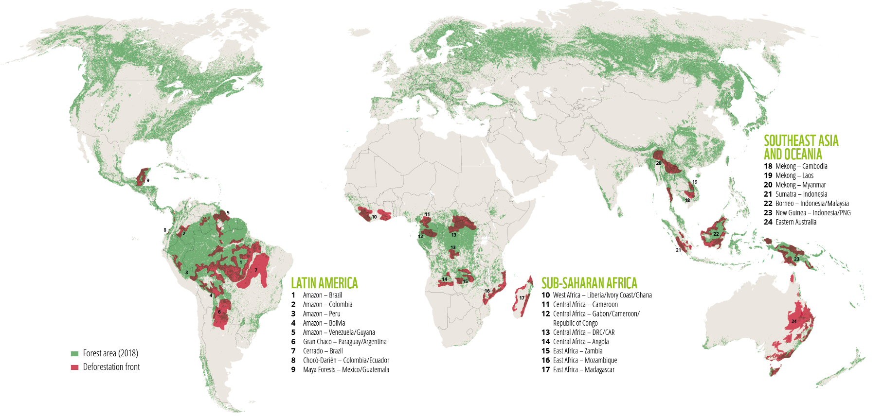
Font: WWF
According to a deforestation report from the World Wildlife Fund, we lost over 160,000 square miles between 2004 and 2017.
Agriculture is the leading driver of global deforestation, fueled by increased food consumption. Palm oil plantations, in particular, have a significant impact. Palm oil is primarily used for cooking in developing countries and is also found in food products, detergents, cosmetics, and, biofuel.
While plantations expand across Asia, Africa, and Latin America, providing job opportunities for local communities who, drawn by the prospect of decent wages, do not realize the long-term consequences, this growth is causing widespread destruction of critical habitat for many endangered species including orangutans, rhinos, elephants and tigers. Moreover, burning forests to make room for the crop is also a major source of greenhouse gas emissions and intensive cultivation methods result in soil pollution, erosion, and water contamination.
With better management practices, the palm oil industry can thrive without harming forests. By enforcing strict production criteria, oil palm plantations can operate sustainably without encroaching on rainforests.
WWF is actively involved in this effort by:
Promoting sustainable palm oil production through the Roundtable on Sustainable Palm Oil (RSPO), which includes palm oil producers, buyers, and environmental groups
Encouraging companies to use certified sustainable palm oil in their products
Working to remove incentives that drive forest destruction for palm oil production
In Borneo, forests are disappearing rapidly, with palm oil plantations and illegal logging causing the loss of half the island’s forest cover in the past 50 years.
Due to poverty and limited access to healthcare, many residents have turned to illegal logging.
Founded in 2006, Health in Harmony (HIH) is a rainforest conservation organization that supports the health of people, ecosystems, and the planet by collaborating with rainforest communities on solutions in healthcare, livelihoods, and education.
Although Indigenous Peoples and Local Communities represent only 6% of the global population, they protect over 80% of Earth’s biodiversity. HIH believes these communities are the experts the world must listen to and work with to address the climate crisis.
In 2017, the company launched a chainsaw buyback program, offering farmers money and support to establish alternative livelihoods in exchange for turning in their chainsaws. HIH’s healthcare clinic allows residents to pay in whatever way they can, whether with cash, seedlings, manure, rice husks, or other available resources and the medical centre provides also discounts to villages that demonstrate a reduction in illegal logging.
A 2020 Stanford University study, published in the Proceedings of the National Academy of Sciences, detailed the ten-year impact at a proof-of-concept site in West Kalimantan, Indonesia. Encouraged by the positive outcomes, HIH developed a plan to scale up their efforts, expanding to additional sites in West Kalimantan (Bukit Baka Bukit Raya), the Manombo Forest in southern Madagascar, and the Xingu River Basin in the Amazon Rainforest, Brazil.
Here are some interesting numbers:
8.7 million hectares of rainforest protected 88,441,929 pounds of carbon dioxide protected in Indonesia 10,322 patient visits conducted across all sites 697 under-5 infants received healthcare in Borneo 3,000+ orangutans protected in Borneo Increased access to family planning and birth control at all program sites 42,000+ old-growth trees protected in Borneo through Chainsaw Buyback 1,690 community members received benefits from our Conservation Stimulus package in Indonesia 10,196 people in 28 villages supported through community outreach programs in Borneo 87,295+ signatures on our petition to U.S. Congress on future pandemic prevention
In 2024, HIH aims to protect 11 million hectares of rainforest across Indonesia, Madagascar, and Brazil, with Indigenous Peoples and local communities leading the efforts. This includes an additional 1.65 million hectares to be safeguarded this year. The organization will also support 335,000 people in these regions as they work to protect rainforests globally.
The Buzău Mud Volcanoes are one of the strangest natural attractions in Romania, where bubbling mud, gas emissions and dry, cracked earth create a landscape that looks more like another planet than southeastern Europe. Located near Berca in Buzău County, the volcanoes form part of the Buzău Land UNESCO Global Geopark and are among Romania’s most unusual geological sights.
Unlike conventional volcanoes, these formations do not erupt molten rock. Instead, underground gases force water, clay and mineral-rich mud towards the surface, where it accumulates around small vents and gradually creates cone-shaped formations. The mud is cold rather than hot, making the experience particularly unusual for anyone expecting a traditional volcanic landscape.
The two main areas are Pâclele Mari and Pâclele Mici. They are close to each other but have noticeably different landscapes, and visiting both gives you a much better impression of this unusual geological phenomenon.
A Strange Landscape Created by Gas and Mud
The Buzău Mud Volcanoes are not volcanoes in the traditional sense. Deep below the surface, geological formations contain water, clay, salt and hydrocarbons. Natural gas under pressure moves upwards through faults and fractures in the Earth’s crust, carrying water and fine sediment with it.
When this mixture reaches the surface, the mud spreads around the gas vent. Repeated eruptions gradually build small cones, while other vents produce pools where gas bubbles continuously rise through the mud. The process is still active today, which means that the appearance of the landscape can change over time.
The result is a remarkably barren environment. Dry mud forms deep polygonal cracks across the ground, while channels develop where mud has flowed downhill. Some vents remain active and bubble continuously, while others have dried out and become small cones.
The almost complete absence of vegetation makes the landscape even more striking. Combined with the grey and brown colours of the mud, the cracked ground and hundreds of small cones, the area has an almost lunar appearance.
Pâclele Mari, meaning “Big Pâclele”, is one of the two principal mud-volcano areas and is particularly easy to visit by car. The site consists of an exposed plateau covered with mud cones, craters and channels. Some formations are active, while others have dried and developed the characteristic cracked surface.
The official Buzău Land UNESCO Global Geopark describes the area as containing the largest mud volcano in Europe, a broad shield-like formation on which smaller cones have developed.
A short thematic trail allows visitors to explore the formations and learn about the geological processes responsible for them.
Despite its name, Pâclele Mici, or “Small Pâclele”, can be just as impressive. This area contains an extensive field of mud volcanoes spread across a broad plateau, with numerous cones, craters and bubbling pools. From higher ground, the scale of the landscape becomes particularly apparent.
The two sites are close enough to combine in one visit, and if you have time, it is definitely worth seeing both.
Visiting the Buzău Mud Volcanoes
The best time to visit the Buzău Mud Volcanoes is from late spring to early autumn. May, June and September generally offer comfortable temperatures, while July and August tend to be hotter and provide the driest conditions.
Summer can be very hot because there is little shade on the exposed plateaus, so visiting early in the morning or later in the afternoon is more comfortable.
Rain is more important than temperature when planning a visit. Heavy rainfall can make the terrain extremely muddy and slippery, and some areas may become difficult to access. After dry weather, on the other hand, the ground becomes much harder and the characteristic cracks in the mud are particularly visible.
Wear comfortable shoes with good grip and bring water, sunscreen and a hat during the warmer months. There is little shade around the main volcanic areas.
Allow around 2–3 hours to explore the principal sites at a relaxed pace. If you want to walk between Pâclele Mari and Pâclele Mici, allow around half a day. The official route between the two areas is approximately 6.2 km and takes about three hours, including the surrounding trail.
How to Get There
The easiest way to reach the Buzău Mud Volcanoes is by car. The sites are located near Berca, around 30 km from Buzău.
From Buzău, follow the signs towards Berca and then towards the Vulcanii Noroioși, the Romanian name for the mud volcanoes. Local roads lead towards both Pâclele Mari and Pâclele Mici, with parking areas close to the attractions.
If travelling from Bucharest, the journey generally takes around two to three hours, depending on traffic. A rental car is the most convenient option, particularly if you want to visit both volcanic areas and other attractions around Buzău Land.
Public transport is possible for reaching Berca, but getting from the town to the volcanic sites is considerably less convenient. For independent travellers, driving is therefore the best option.
Exploring Buzău Land
The mud volcanoes are only one of the geological attractions found in the wider Buzău Land UNESCO Global Geopark. The region contains unusual rock formations, caves, fossils, mountains and other geological features, making it an excellent destination for travellers interested in natural landscapes.
Nearby, the Fierbătorile de la Beciu are another interesting geological phenomenon, where gases bubble through liquid mud and water, creating pools that appear to be boiling.
Combining the mud volcanoes with other attractions in Buzău Land makes for a much more rewarding trip than visiting the volcanoes as a quick stop from Buzău. The region remains considerably less visited than Romania’s famous castles and Carpathian destinations, which is part of its appeal.
The Buzău Mud Volcanoes are particularly memorable because they offer something that is difficult to find elsewhere in Romania: an active geological landscape of bubbling mud, barren hills and constantly changing formations.
For travellers exploring southeastern Romania, Pâclele Mari and Pâclele Mici are well worth adding to the itinerary, especially for anyone interested in geology, unusual landscapes and places that feel completely different from the country’s better-known attractions.
For many people in towns such as Warrington, everyday travel is rarely about one single journey.
It is the trip from home to the station. The ride from a residential area into the town centre. The short journey to work, college, the shops or a local appointment. It is also the practical question of where to store a bike, how to keep it secure and whether cycling can fit around a busy working day.
That is why folding electric bikes are becoming more relevant.
They are not designed to replace every car journey, every bus ride or every full-size bicycle. Their value lies in flexibility. A folding electric bike can help people make shorter journeys more easily, combine cycling with public transport and solve one of the biggest barriers to everyday bike use: storage.
In a place like Warrington, where local travel often sits between car, bus, train, walking and cycling, compact electric mobility can be especially useful.
Why Folding Electric Bikes Fit Modern Local Travel
A full-size bike works well for many people, but it is not always easy to live with.
Some homes have limited storage. Some workplaces do not offer secure cycle parking. Some riders need to combine cycling with a train, bus or car journey. Others may want a bike for short local trips but do not want a large vehicle taking up space in a hallway, flat, garage or office.
This is where a folding electric bike becomes practical.
For residents who need a bike that can fit into a flat, office, car boot or mixed commute, afolding electric bike can make everyday cycling easier to start and easier to keep using.
The folding function is not just a novelty. It changes where the bike can go and how it can be used. A compact e-bike can be stored indoors more easily, taken on certain journeys more conveniently and kept closer to the rider, reducing reliance on outdoor parking.
For many people, that difference is important. A bike that is easy to store is more likely to be used. A bike that feels difficult to manage may stay at home.
The Short Journey Problem
Many local car journeys are short.
People drive to the shops, the station, the office, the gym, a café, a friend’s house or a town-centre appointment. These journeys are understandable. A car is familiar, weatherproof and convenient. But for short local trips, it can also mean parking pressure, traffic delays, fuel costs and unnecessary congestion.
Cycling can solve some of these problems, but ordinary cycling is not always realistic for everyone. Distance, tiredness, hills, headwind, work clothes and time pressure can all make the bike feel less attractive.
Electric assistance lowers that barrier.
A folding electric bike adds another benefit: compactness. It supports the short journey itself and also makes storage easier at either end. This makes it useful not only as a transport choice, but as a daily habit.
For local travel, convenience often matters more than maximum speed or long-distance performance. If a bike makes the first mile and last mile easier, it can change how people move around town.
Commuting Without Needing a Large Bike
Commuting is one of the strongest use cases for a folding electric bike.
Not every commuter rides long distances. Many people only need to cover a few miles between home, work, station, bus stop or town centre. For that kind of journey, a compact electric bike can be more practical than a larger e-bike.
The rider gets assistance when setting off, climbing small inclines or dealing with wind. At the same time, the bike can be folded or stored more easily when space is limited.
This matters for people who live in flats, terraced houses or shared accommodation. It also matters for workers who cannot leave a full-size bike outside all day. If the bike can be brought indoors or placed in a more secure space, the whole commuting routine becomes less stressful.
A folding electric bike also works well for mixed commuting. A rider may drive part of the way, park outside a busy area and use the bike for the final section. Another rider may combine the bike with rail or bus travel where rules and space allow. A third rider may keep the bike at work for short journeys during the day.
The main point is flexibility. The bike does not need to dominate the journey. It can simply make part of the journey easier.
Folding Electric Bike vs Full-Size Electric Bike
A full-size electric bike has clear advantages.
It may feel more stable on longer rides, offer larger wheels, carry more accessories and provide greater comfort over distance. For riders who commute many miles each day or use their bike as a primary vehicle, a full-size electric bike may be the better choice.
A folding electric bike solves a different problem.
It is designed for people who need compact storage, easier transport and more flexible daily use. The trade-off is that smaller wheels and folding frames can feel different from a standard bicycle. Some riders may notice a more compact riding position or a slightly different handling feel.
That does not make one category better than the other. It means the right choice depends on the journey.
For a long open-road commute, a full-size model may be ideal. For shorter urban routes, limited storage and mixed transport, a folding electric bike can be more practical.
Folding Mechanism: Convenience Must Meet Safety
The folding mechanism is one of the most important engineering parts of the bike.
A good folding system should be easy to use, but it must also be secure. The hinge, locking system and frame design need to hold firmly during riding. A folding bike that is quick to collapse but feels unstable on the road is not a good solution.
Riders should look for a mechanism that feels solid and intuitive. It should not require excessive force, and it should not create uncertainty about whether the frame is locked correctly.
The folding process also needs to match real life. If folding takes too long or feels awkward, the rider may stop using that feature. The best folding electric bike is not necessarily the one that folds into the smallest possible shape. It is the one that folds reliably, stores conveniently and still feels safe and stable when ridden.
For daily commuting, that reliability matters more than impressive marketing claims.
Weight Still Matters
A folding electric bike is compact, but it is still an electric bike.
That means it includes a motor, battery, wiring and stronger components than a normal folding bicycle. As a result, weight remains an important factor.
A bike may fold neatly, but if it is too heavy to lift, carry or place in a car boot, the benefit is reduced. Riders should think honestly about how they will use it. Will they need to carry it upstairs? Lift it into a train? Move it through a hallway? Store it under a desk? Put it in the back of a car?
A few kilograms can make a noticeable difference in daily use.
At the same time, lighter is not always automatically better. A bike still needs a strong frame, reliable brakes, a safe battery system and enough range for the intended route. The goal is not simply to find the lightest folding e-bike. The goal is to find the best balance between weight, strength, comfort and everyday usability.
Battery, Range and Charging
Range is another factor that should be matched to real use.
Many folding electric bikes are used for short and medium local journeys. That means they may not need the largest possible battery. A rider travelling a few miles each way may care more about easy charging, battery reliability and manageable weight than extreme range.
However, a useful range buffer is still important. Weather, rider weight, assistance level, road conditions and tyre pressure can all affect how far an e-bike travels on one charge. A bike that looks sufficient on paper may feel less practical if the rider always worries about running out of power.
Charging convenience also matters. A removable battery can be useful for people who cannot bring the whole bike near a power socket. For flat dwellers or workers who store the bike away from home, this can be a major advantage.
Battery management should be simple. A clear display, predictable range and easy charging routine make the bike easier to live with.
Brakes, Tyres and Everyday Road Conditions
Local roads are not always smooth.
Town-centre streets, side roads, potholes, wet surfaces, kerbs, cycle lanes and shared paths all place demands on a bike. A folding electric bike must be compact, but it still needs to feel safe in real riding conditions.
Brakes are especially important. An e-bike is often heavier and faster than a normal bicycle, so predictable stopping power is essential. Riders should feel confident when slowing down at junctions, in traffic and around pedestrians.
Tyres also matter. Smaller wheels can be responsive, but tyre quality, pressure and width affect comfort and grip. Good tyres help the bike feel more stable on uneven surfaces and in wet weather.
Lighting should not be overlooked. Many commuters ride early in the morning, in the evening or during darker winter months. Built-in or reliable add-on lights are essential for visibility.
A folding electric bike should be judged not only by how compact it becomes when folded, but also by how safe and controlled it feels when unfolded and ridden.
Security and Storage
One of the biggest advantages of a folding electric bike is that it may be easier to store securely.
Bike theft is a real concern for many riders. A full-size e-bike left outside for long periods can feel risky. A folding model gives more options. It may be possible to bring the bike into a workplace, hallway, flat, storage room or other protected space.
That does not mean security can be ignored.
A strong lock, sensible parking habits and awareness of where the bike is left are still important. If the battery is removable, taking it indoors can also reduce risk and protect battery condition.
Storage is not just about theft. It also affects weather protection and maintenance. A bike stored indoors or under cover is less exposed to rain and temperature changes. That can help preserve components and make the bike more pleasant to use.
For many people, secure storage is the difference between occasionally cycling and cycling regularly.
Choosing the Right Electric Bike for the Journey
Choosing anelectric bike should start with the real journey: distance, storage, road conditions, charging, security and whether the bike needs to work alongside public transport.
A rider with a garage and a long daily commute may prefer a full-size commuter e-bike. A rider with children or heavy loads may need a cargo e-bike. A rider who wants recreational comfort may choose a touring-style model.
But a rider who needs compact storage, short local mobility and flexible commuting may find a folding electric bike more suitable.
The key is to avoid choosing by one feature alone. A large battery is useful only if the rider needs it. A very small folded size is useful only if the bike remains comfortable and stable. A low price is attractive only if the bike remains reliable.
The best e-bike is the one that fits the actual routine.
Fiido X, D11 and D3 Pro as Compact Mobility Examples
Different folding and compact e-bikes suit different needs.
Fiido X represents a more refined folding urban concept. It is designed for riders who want compact storage, a clean design and a more advanced everyday commuting feel. This kind of bike may appeal to users who want a folding e-bike that still feels modern and polished.
Fiido D11 sits closer to practical compact commuting. It is suitable for riders who want a lightweight-feeling electric bike for short daily travel, storage convenience and urban routes.
Fiido D3 Pro is more minimal and compact. It fits the idea of simple local mobility, where the main priorities are easy handling, short trips and a small footprint.
These models show that folding electric bikes are not all the same. Some are more design-focused, some are more practical, and some are built around simplicity. The right option depends on where the rider lives, how far they travel and how often they need to fold or store the bike.
When a Folding Electric Bike May Not Be the Best Option
A folding electric bike is useful, but it is not perfect for everyone.
For long-distance riders, a full-size e-bike may offer more comfort. For heavy cargo, a cargo bike is more suitable. For rough trails or fast recreational riding, a specialist bike will be a better choice.
Some riders may also prefer the feel of larger wheels. Folding bikes can feel more compact and responsive, which is useful in town but different from a standard frame.
Storage should also be considered honestly. If a rider never needs to fold the bike and has plenty of secure space, a full-size model may offer better value and comfort.
The folding feature is most valuable when it solves a real problem: limited space, mixed commuting, indoor storage or car-boot transport.
Folding E-Bikes and the Future of Town Mobility
Towns such as Warrington need a mix of transport options.
Cars will continue to play an important role, especially for longer journeys, family trips and situations where carrying capacity is necessary. Public transport will remain important for moving larger numbers of people. Walking will always be the simplest choice for very short distances.
Cycling and e-bikes sit between these options.
They are faster than walking, lighter than cars and more flexible than fixed-route public transport. Folding electric bikes add another layer by making the vehicle easier to store, carry and combine with other modes of travel.
This is why they fit the direction of modern local mobility. The future is not about one transport solution replacing all others. It is about giving people more practical choices for different journeys.
For many short local trips, a compact electric bike can be enough.
Conclusion: Compact, Flexible and Practical
A folding electric bike is not just a smaller version of a standard e-bike.
It is a practical mobility tool designed around real everyday problems: limited storage, mixed commuting, short local journeys, security and flexible movement around town.
For Warrington residents, it can make cycling easier to fit into daily life. It can help with the journey to work, the station, the shops, the town centre or a nearby appointment. It can reduce dependence on short car trips without asking people to give up convenience.
The best folding electric bike is not necessarily the one with the biggest battery or the smallest folded size. It is the one that fits the rider’s route, storage space, handling needs and daily routine.
When those elements come together, compact electric mobility becomes more than a trend.
It becomes a realistic part of everyday travel.
-sponsored-
This website uses cookies to improve your experience. We'll assume you're ok with this, but you can opt-out if you wish. Cookie settingsACCEPT
Privacy & Cookies Policy
Privacy Overview
This website uses cookies to improve your experience while you navigate through the website. Out of these cookies, the cookies that are categorized as necessary are stored on your browser as they are essential for the working of basic functionalities of the website. We also use third-party cookies that help us analyze and understand how you use this website. These cookies will be stored in your browser only with your consent. You also have the option to opt-out of these cookies. But opting out of some of these cookies may have an effect on your browsing experience.
Necessary cookies are absolutely essential for the website to function properly. This category only includes cookies that ensures basic functionalities and security features of the website. These cookies do not store any personal information.
Any cookies that may not be particularly necessary for the website to function and is used specifically to collect user personal data via analytics, ads, other embedded contents are termed as non-necessary cookies. It is mandatory to procure user consent prior to running these cookies on your website.