
Tanezrouft is one of the most extreme and inhospitable regions of the world, stretching across the Sahara Desert, between southern Algeria and northern Mali. Often referred to as the “Land of Terror” or “Land of Thirst” it is a vast hyper-arid expanse where survival is nearly impossible without modern navigation and supply support.
Located west of the Hoggar Mountains and extending toward the central Sahara plateau, Tanezrouft, is defined by its complete lack of vegetation, water sources, and permanent settlements. Temperatures regularly exceed 50°C in summer, while annual rainfall is measured in only a few millimetres, making it one of the driest places on Earth.
The name “Land of Terror” comes from the extreme danger faced by travellers crossing the region. Historically, caravans avoided Tanezrouft due to its endless barren plains, disorienting landscapes, and absence of wells or oases. Even today, the area is considered one of the most hostile environments in the Sahara, where mechanical failure or getting lost can be life-threatening.
Modern references, including satellite observations and geological studies, highlight the basin’s extreme isolation and harsh climate, reinforcing its reputation as a place where nature offers almost no margin for survival.
Landscape and Geological Features
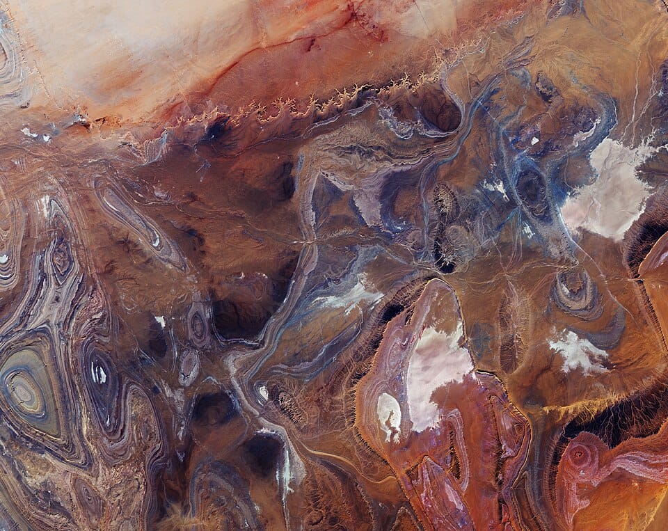
Despite its harshness, Tanezrouft is visually striking from above. The terrain is shaped by a combination of ancient geological structures and long-term erosion processes.
The region consists mainly of dark sandstone plateaus, deeply eroded canyons, and exposed folded rock layers dating back hundreds of millions of years. Strong winds, frequent sandstorms, and minimal vegetation have stripped away softer surface materials, revealing dramatic geological patterns beneath.
Satellite imagery shows concentric rings, ridges, and linear folds in the rock strata, creating natural patterns that resemble abstract art. In some areas, canyon walls rise up to 500 metres, while lower basins contain salt flats that indicate past episodes of intermittent water flow.
These formations suggest that the Sahara was not always a desert. Geological evidence indicates that ancient flooding events and wetter climatic periods once shaped the region before long-term desertification transformed it into today’s hyper-arid environment.
Climate and Environmental Extremes
Tanezrouft is classified as a hyperarid desert. Rainfall is extremely rare and often does not exceed a few millimetres per year. The combination of intense solar radiation, dry air, and persistent wind erosion creates a landscape with almost no organic life.
Daytime temperatures can become extreme, while nighttime conditions may drop sharply due to the lack of humidity. The absence of water and vegetation means there are no natural buffers against heat or wind, making exposure particularly dangerous.
Human Presence and Travel
There are no permanent settlements in Tanezrouft. The only human presence comes from occasional Tuareg nomads and modern trans-Saharan routes.
A major highway crosses parts of the region, linking Algeria with Mali, but even this infrastructure highlights the difficulty of the environment, often passing through vast stretches of empty terrain with no services for hundreds of kilometres.
Historically, the region was avoided by caravan routes because of the high risk of dehydration and disorientation. Even today, travellers are advised to treat it as a remote wilderness requiring full logistical preparation.
Geological Importance
Beyond its extreme climate, Tanezrouft is scientifically significant because it exposes deep geological structures that are rarely visible elsewhere. The lack of soil and vegetation allows geologists to study folded sedimentary layers and erosion patterns directly.
The region also provides insight into long-term climatic change in the Sahara, showing how shifting environmental conditions over millions of years transformed a once-variable landscape into one of the driest zones on the planet.
A Landscape of Silence and Scale
What makes Tanezrouft remarkable is not just its hostility, but its scale. The absence of human activity, vegetation, and water creates a landscape where geological time is visible in its raw form. From space, it appears as a vast patterned surface of rock, sand, and erosion lines — one of the most visually dramatic desert regions on Earth.
For geologists and satellite observers, it remains a natural laboratory. For travellers, it remains a place that demands respect, preparation, and caution.