Nestled in County Down in Northern Ireland, the Mourne Mountains are a paradise for hikers, nature lovers, and adventurers. Designated as an Area of Outstanding Natural Beauty (AONB), the Mournes offer dramatic peaks, peaceful valleys, tranquil lakes, and a network of well-maintained trails. With over 30 marked hiking routes ranging from easy walks to challenging climbs, this region stands as the most prominent mountain range in Northern Ireland.
The Mourne Mountains are famed for their rugged beauty and distinctive granite peaks. Slieve Donard, at 850 metres, is the highest point in Northern Ireland and a popular summit for both seasoned climbers and enthusiastic amateurs. Other major peaks include Slieve Binnian, Slieve Bearnagh, and Slieve Meelmore, all offering panoramic views across the Irish Sea, nearby valleys, and even Scotland on a clear day.
The Mourne Wall – A Miniature Great Wall of Ireland
One of the most striking man-made features of the Mournes is the Mourne Wall, a 35-kilometre (22-mile) dry-stone wall built between 1904 and 1922. Constructed to enclose the catchment area of the Silent Valley Reservoir, the wall crosses 15 of the highest mountains in the range. It winds over peaks and across valleys with such purpose and precision that it could be likened to a miniature version of the Great Wall of China.
Many hikers choose to follow segments of the wall as a natural guide through the hills, and some even take on the full Mourne Wall Challenge Walk, a strenuous but rewarding one-day trek that covers the entire route.
The Mournes boast over 30 marked trails, offering everything from gentle family walks to intense mountain hikes. Some of the most popular routes include:
The Glen River Trail to Slieve Donard begins at Donard Park in Newcastle and ascends steadily through forest and mountain terrain.
The Binnian Loop Walk – a moderate to strenuous loop with breathtaking views over the Silent Valley and Annalong Valley.
The Trassey Track to Slieve Bearnagh – known for its dramatic tors and sweeping views.
The Ott Track to Slieve Loughshannagh and Doan – a less crowded but spectacular path through peatland and granite scenery.
The variety and quality of trails make the Mourne Mountains an ideal year-round destination for hikers of all levels.
Silent Valley and the Lakes of the Mournes
The Silent Valley Reservoir, set deep within the mountains, is one of the area’s most serene and scenic destinations. Managed by Northern Ireland Water, this reservoir not only supplies water to the region but also provides a peaceful setting for walking trails, picnics, and nature photography.
Nearby, Ben Crom Reservoir and Lough Shannagh offer additional points of interest for those seeking quiet retreats surrounded by nature.
Main Car Parks and Starting Points
Access to the Mourne Mountains is well-established, with several key car parks and trailheads scattered around the perimeter:
Donard Park (Newcastle) – ideal for accessing Slieve Donard and the Glen River Trail.
Carrick Little Car Park – starting point for the Slieve Binnian loop and access to the Silent Valley.
Ott Car Park – a quieter access point for the central Mournes, ideal for routes to Doan and Lough Shannagh.
Meelmore Lodge Car Park – provides access to Slieve Meelmore, Slieve Bearnagh, and the Trassey Track.
Silent Valley Car Park – great for families and easy walking trails around the reservoir.
Where you stay during your trip can define how you experience a place. A hostel in Vietnam feels wildly different from a countryside B&B in France or an eco-lodge in Costa Rica. That’s why choosing the right type of accommodation matters. It should match not just your budget, but how you like to travel.
In this guide, we’ll look at a range of options so you can find the right fit for your next trip.
Hostels are perfect for travellers who care more about experiences than luxury. They’re usually affordable, centrally located, and great for meeting other travellers over breakfast or in the common room.
They work best for solo adventurers, younger travellers, or anyone who doesn’t mind shared spaces. Just make sure to check reviews for cleanliness, safety, and whether the vibe suits you; some hostels are chill and quiet, others feel like 24/7 parties.
Charming Bed & Breakfasts: Comfort with a Personal Touch
B&Bs are great when you want something warmer and more personal than a hotel. They’re usually small, often run by locals, and come with thoughtful touches, like homemade breakfasts and friendly hosts.
They’re ideal if you’re after a peaceful stay with a bit more comfort. B&Bs give you a slower, more personal travel experience.
Mid-Range Hotels and Boutique Stays
Boutique hotels strike a nice balance, more character than a chain, but still affordable. They often reflect local design, offer personalised service, and feel thoughtfully put together. You’re not just booking a room, you’re choosing a vibe.
They’re perfect if you want something stylish and comfortable without going full luxury. When picking one, check photos, recent reviews, and look for places that feel in tune with the area.
Eco-lodges are all about getting off the grid and into nature. They focus on sustainability and offer a peaceful stay in forests, mountains, or near the ocean; ideally with minimal impact on the environment.
If you love quiet places, starry skies, and waking up to birds instead of traffic, this is your kind of stay. They’re great for travellers who care about the planet and want a slower, more mindful travel experience. Just know that Wi-Fi might be weak, and amenities more basic.
How to Pick the Right Accommodation for You
Choosing where to stay isn’t just about price, it’s about how you like to travel. Think about your budget, how much comfort you need, who you’re travelling with, and where you’re headed. A hostel might work great for a city stop, while a quiet B&B or eco-lodge fits better in nature.
Always read recent reviews and double-check the amenities; what looks good in photos doesn’t always match reality. And don’t be afraid to mix things up: a hostel for a few nights, then a boutique hotel to recharge. Flexibility makes the trip more fun.
Booking Made Easy with Cozycozy
Finding the right place to stay doesn’t have to mean opening ten tabs. Sites like cozycozy are helpful for comparing different styles of stays across dozens of platforms, all in one search. Whether you’re hunting for a hostel, a B&B, or a remote eco-lodge, it pulls everything into one clear view.
It saves time and helps you spot options you might’ve missed otherwise. Use filters for traveller ratings, price range, or accommodation type to quickly narrow things down. It’s a smart way to book something that really fits your trip.
The United Arab Emirates is known for its thriving automotive market, where car enthusiasts and everyday drivers alike have access to a wide variety of vehicles, from the latest models to pre-owned gems. The allure of high-end cars, well-maintained vehicles, and a car-loving culture has made the UAE a hotspot for both new and used car buyers. Many residents, expats, and even international buyers are drawn to the country’s dynamic market not only because of the extensive choices available but also because of the transparency and affordability offered in the second-hand segment.
If you’re considering exploring the market for used cars in Abu Dhabi for sale, you’re in for a promising experience. Abu Dhabi, being the capital of the UAE, has a particularly strong and diverse inventory of used vehicles. Whether you are seeking a practical sedan for daily commuting, a luxury SUV to match the city’s high standards, or an economical compact car, the options are vast. One of the key advantages of buying in Abu Dhabi is the fact that most cars on the market tend to be relatively new, well-maintained, and often come with complete service histories. This is mainly due to strict vehicle inspection regulations and a cultural tendency toward upgrading vehicles frequently.
What Makes Abu Dhabi an Ideal Place to Buy Used Cars
There are several factors that contribute to the booming used car industry in Abu Dhabi. Firstly, the city’s residents usually drive in good road conditions, which helps maintain the vehicle’s quality over time. Additionally, there is a significant portion of expatriates who often sell their vehicles before leaving the country, providing a steady supply of used cars in excellent condition. The relatively low mileage and detailed maintenance records that accompany many of these cars add to their appeal and resale value.
Car dealerships and private sellers alike cater to a wide audience, offering vehicles that range from affordable entry-level models to high-performance sports cars. Many dealerships also provide financing options, insurance packages, and vehicle inspection reports, giving buyers peace of mind when making a purchase. Furthermore, online platforms have made it easier than ever to browse, compare, and secure a great deal on a pre-owned car without needing to visit multiple showrooms physically.
Factors to Consider Before Buying a Used Vehicle
Before purchasing a used vehicle in Abu Dhabi or anywhere else in the UAE, it’s important to perform due diligence. This includes checking the car’s accident history, verifying service records, and having a trusted mechanic inspect the vehicle. It’s also essential to confirm the validity of ownership documents and ensure the car has no pending fines or legal issues. Most sellers and platforms are aware of the buyers’ expectations and will readily provide this information, especially in a regulated environment like Abu Dhabi.
The process of transferring ownership is relatively straightforward. Once the buyer and seller agree on a price, the necessary documentation is submitted to the relevant traffic department. Insurance is arranged, and the new registration certificate is issued under the buyer’s name. The availability of government support and efficient services makes the entire process smooth and reliable.
Why Pre-Owned Vehicles Offer Better Value
Opting for a pre-owned vehicle often proves to be a smarter financial decision. New cars typically depreciate by 20 to 30% within the first year, and even more in subsequent years. Buying a used car allows you to avoid that initial drop in value while still enjoying a relatively modern vehicle with the latest features. In a place like Abu Dhabi, where people tend to upgrade their cars every few years, it’s possible to find gently used vehicles that still feel and drive like new.
In addition, insurance premiums for used cars are generally lower than those for new models. The same applies to registration fees and taxes, which can make owning a car more affordable overall. For families or individuals on a budget, these savings can be significant over time, allowing them to invest in other aspects of their lives while still enjoying the freedom and convenience of car ownership.
Market Trends and Buyer Behaviour
Trends in the used car market reflect shifting consumer behaviours. In recent years, there’s been a growing interest in environmentally friendly and fuel-efficient vehicles. Buyers are increasingly aware of carbon emissions and fuel costs, and as a result, hybrid and electric models are gaining traction in the second-hand market. However, traditional fuel-powered vehicles still dominate the listings, especially those from trusted manufacturers known for durability and low maintenance costs.
The UAE’s multicultural population also plays a role in market preferences. Different nationalities tend to favor different types of vehicles based on lifestyle and driving habits, which further enriches the used car inventory. For example, off-road enthusiasts often seek pre-owned 4x4s and rugged SUVs, while city dwellers might gravitate towards compact sedans and hatchbacks. The diversity of choices means that no matter your preferences, budget, or driving needs, there’s likely a perfect match waiting for you in the market.
The Role of Technology in Used Car Shopping
Technology has completely transformed the way people shop for cars in the UAE. From browsing online marketplaces to conducting virtual inspections and securing financing digitally, buyers can now complete most of the buying process without even stepping outside their homes. Virtual tours, HD image galleries, car history reports, and chat-based customer service are all standard features on most platforms. These digital tools give buyers a comprehensive view of their options and enable informed decision-making.
Mobile apps and websites also make it easier to filter vehicles by make, model, year, mileage, and price. This saves time and effort, especially for those with specific requirements. Whether you’re searching for an affordable daily driver or a luxury vehicle at a fraction of its original cost, technology streamlines the process and increases buyer confidence.
Finding Reliable Sellers and Verified Listings
Reputation and trustworthiness are key factors when choosing where to buy a used car. Many buyers prefer authorised dealerships and certified resellers due to the added guarantees and services provided. However, private sellers can also offer excellent deals, provided the transaction is handled carefully and with full transparency. It’s advisable to always ask for a test drive, verify the vehicle identification number, and cross-check all documentation before proceeding.
Used car showrooms in Abu Dhabi are usually regulated and must meet certain criteria, offering buyers additional peace of mind. Some sellers even provide limited warranties on used cars, adding a layer of protection for new owners. Online platforms also play a role in this ecosystem by displaying only verified listings and enabling reviews from past customers.
As the market continues to evolve and more players enter the space, competition will only benefit buyers, leading to better prices, enhanced services, and wider selection. With the right approach and a bit of research, securing a reliable pre-owned vehicle in the UAE is a highly attainable goal.
In recent years, even international buyers have shown increased interest in importing vehicles from the UAE due to the excellent condition and lower prices of many listings. This trend has further elevated the region’s position as a hub for used car sales. Whether you’re based in Abu Dhabi or any other part of the UAE, the demand for pre-owned vehicles remains strong and vibrant. If you’re looking for a solid, well-maintained used car Dubai has plenty of choices to offer, rounding out a market full of opportunity and convenience for every kind of driver.
Dubai is one of the world’s most dynamic and visually stunning cities. It’s a place where futuristic skylines meet golden deserts and where each neighborhood offers something different. From the cosmopolitan energy of Downtown to the sandy shores of Jumeirah and the business districts of DIFC and Internet City, getting around efficiently becomes essential for both residents and visitors. Although public transport has improved, the most flexible way to move through the city remains the personal car.
This is why car rent Dubai services have become so popular. Whether you’re visiting for a few days or settling in for an extended stay, having access to your own vehicle transforms your experience. No waiting for taxis, no worrying about bus schedules—just the freedom to explore at your own pace. The roads in Dubai are wide and well-maintained, fuel is relatively affordable, and parking is generally accessible, especially in new residential and commercial developments.
A Rental for Every Need and Every Budget
Car rental services in Dubai are as diverse as the city itself. You can find everything from compact hatchbacks for everyday errands to sleek luxury sedans for business appointments or family SUVs for weekend adventures. There’s also a wide range of exotic and sports cars for those looking to make a bold statement during their stay. What makes Dubai truly unique is the ease with which these vehicles can be accessed. With a simple online booking and the right documents, your desired car can be delivered to your hotel, office, or home within hours.
Daily and weekly rentals work perfectly for short-term visitors or travelers who want to explore more than just one neighborhood. Many tourists use a rental car to take trips to the desert, visit Dubai Parks and Resorts, or even venture to Abu Dhabi and back in a single day. Business travelers often appreciate the punctuality and comfort a rental offers, especially when moving between meetings or networking events across the city.
The Advantage of Long-Term Rentals in Dubai
While short-term rentals offer flexibility, long-term options provide unbeatable value and convenience. Many residents, expats, and remote workers choose to rent a car monthly instead of buying one. This approach eliminates the need for registration, insurance payments, and annual maintenance. It also removes the financial burden of a down payment or bank financing.
Long-term car rentals often come with perks such as scheduled servicing, replacement vehicles during maintenance, and roadside assistance. Rental agencies in Dubai understand the needs of long-term clients and frequently offer lower monthly rates, inclusive packages, and the ability to swap models if your lifestyle or preferences change. This model appeals especially to people on work assignments, freelancers, or digital nomads who want to avoid the commitment of vehicle ownership.
Smooth Roads and Scenery that Beg to Be Explored
Driving in Dubai is more than just practical, it’s part of the experience. The city’s infrastructure is among the best in the world. Roads are clean and spacious, signage is clear and multilingual, and the surrounding environment makes each drive visually rewarding. Even everyday commutes are elevated by the views of Burj Khalifa, the winding Dubai Canal, and the stunning architectural designs that fill the skyline.
For leisure drivers, the appeal of road trips is also a major plus. From Dubai, you can easily explore nearby destinations like the Hatta mountains, the Ras Al Khaimah coastline, or even cross into Oman for a longer adventure. Having your own car makes spontaneous travel easier, turning weekends into memorable getaways. And for families with children, access to a vehicle makes running errands, attending school activities, or visiting relatives significantly more comfortable.
Renting Made Easy with Modern Services
Dubai’s car rental industry is known for its efficiency and customer-first approach. Booking a car is simple, whether online or through a mobile app. Most providers offer multilingual support and 24/7 customer service, ensuring that you always have help when needed. Pickup and drop-off options are flexible, and most agencies are located across major districts, making access easy no matter where you live or stay.
Rental requirements are also straightforward. Tourists need only a valid driver’s license from their home country, a passport, and in some cases, an international driving permit. UAE residents need an Emirates ID and a local driving license. Some providers also offer corporate packages or fleet services for companies in need of business transport. These offerings are tailored to make every transaction quick, transparent, and pleasant.
Cost-Effective and Worry-Free Driving
Financially, renting can often be more manageable than owning. You pay a fixed rate that includes insurance, service, and support. This means no surprise repairs or fluctuating costs. Fuel-efficient vehicles are widely available, allowing you to control how much you spend each week. And because rental cars are regularly maintained and checked, you enjoy peace of mind when it comes to safety and reliability.
Many rental companies also provide value-added services such as GPS devices, baby seats, and Salik (toll) tag setups, making your drives even more comfortable. Some long-term renters enjoy doorstep maintenance, where a representative picks up the car for service and returns it the same day. This level of convenience allows you to focus on your day-to-day life while the logistics are handled by professionals.
Choosing the Right Rental Partner
With so many options on the market, it’s important to choose a reputable rental agency. Look for companies that offer transparent pricing, insurance clarity, and verified customer reviews. The best agencies will work with you to understand your driving needs, suggest appropriate models, and provide a clear rental agreement with no hidden charges.
It’s also worth considering the after-sales service and communication. How quickly do they respond to queries? Do they offer replacement vehicles if something goes wrong? Do they have an in-house support team or outsource their services? These are the details that make a big difference when you’re renting for more than a few days.
As a city built around personal mobility and luxury living, Dubai offers one of the most attractive environments in the world for car rental. The process is easy, the roads are a pleasure to drive, and the variety of cars means there is something for everyone, from budget-conscious drivers to those who prefer high-end brands. Whether you need a vehicle for daily errands, business use, or weekend getaways, renting gives you full control over your schedule and lifestyle. And for those looking for flexibility without long-term ownership, the decision to rent a car Dubai monthly makes perfect sense.
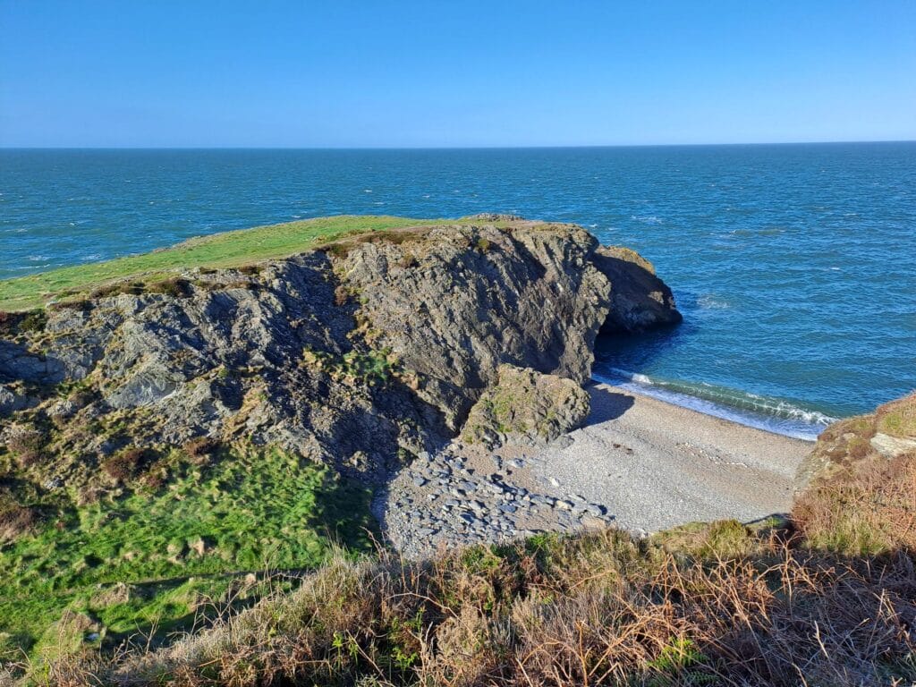
Tucked away on the eastern coast of County Wicklow, the Glen Beach Cliff Walk offers one of the most breathtaking yet lesser-known hikes on Ireland’s East coast. Starting just a short stroll from the charming town of Wicklow, this coastal trail blends dramatic sea views, rugged cliffs, peaceful countryside paths and even a chance to spot wild seals. With no crowds.
The walk begins at Glen Beach, just south of Wicklow Harbour. From the car park, a narrow, well-worn path climbs gently along the cliff edge. As you gain elevation, the views open up across the Irish Sea, with sheer drops to the crashing waves below. It’s a walk that feels wild and invigorating, yet manageable for most walkers.
Not far along the trail, a detour leads down to Lime Kiln Bay, a peaceful cove often visited by a small colony of grey seals. Between August and April, this bay becomes a nursery for seal pups, which are sometimes seen lying quietly on the beach. These pups are often left alone while their mothers are out at sea hunting for fish, and although it may be tempting to get closer, it’s vital to maintain a minimum distance of at least 100 metres.
Approaching a seal pup can cause stress or alarm, and human presence may discourage the mother from returning, leaving the pup vulnerable to starvation. Observing from a distance helps protect the pups and ensures the seal colony remains undisturbed. Dogs must be kept on a lead at all times.
From there, the main trail continues south toward Wicklow Head, where a series of scenic cliffs leads to the old and new lighthouses. The route toward the 18th-century octagonal tower is slightly more rugged but well worth the effort for the panoramic views.
Trail Details: Distance: 4–5 km for the loop, with an optional 2–3 km extension to the lighthouse. Time: 1.5–2 hours including the lighthouse. Difficulty: Moderate – mostly easy paths with a few uneven sections.
Getting There: Wicklow Town is about 40 minutes south of Dublin by car, train, or bus. From the town center, head to South Quay and follow the road signs to Glen Beach, where you’ll find a small parking area with picnic tables. The trailhead starts at the end of the car park.
If you have time after your walk, don’t miss a visit to Wicklow Gaol, one of Ireland’s most atmospheric historic prisons. Located in the heart of Wicklow Town, this 18th-century jail tells the story of Ireland’s troubled past through immersive exhibits and guided tours. You’ll learn about political prisoners, famine-era hardships, and even alleged hauntings
Few places in the world are as naturally beautiful as the Caribbean. It’s a popular destination, but some of its smaller islands remain largely undiscovered.
Over 30 million international tourists visit the Caribbean each year, choosing from a variety of island destinations. Most go for the more “obvious” options, drawn to famous spots seen in the media. That choice makes sense, of course, but it’s not the only one.
For those who want to avoid the usual hotspots and discover something new, there are alternatives. The idea is to enjoy the full experience of the Caribbean islands, but with a different focus, seeing value in what is often overlooked. With that in mind, here are a few tips to follow.
5 tips for planning a non-traditional Caribbean sailing vacation
Based on everything we’ve discussed, here are five suggestions to help you plan a Caribbean sailing trip with “hidden” stops along the way. These are simple and flexible tips that can be adapted to any travel style.
1. Prioritize cultural immersion through accommodation and food
It’s common to plan a Caribbean vacation around five-star hotels and top-rated restaurants. While that can be enjoyable, it also limits your chances of experiencing the real Caribbean—its people and its flavors.
Instead, consider going for cultural immersion. Rather than sticking to trendy restaurants, why not try out a lesser-known local spot? The sense of adventure is part of what makes traveling in the Caribbean so rewarding, and it can be amplified when you’re open to exploring the region’s authenticity.
2. Look for packages that offer unique experiences
Your Caribbean journey can be enhanced by booking packages that offer something different. An off-the-beaten-path itinerary to lesser-known Caribbean islands, for example. That’s exactly what Pyratz SXM offers—a high-end service that avoids many common travel hassles.
They focus on personalized Caribbean sailing vacations to islands like St. Martin, Anguilla, and St. Barts, among others. In addition to the destinations, they offer the chance to explore the region’s food culture, tying back to the previous tip on culinary immersion.
3. Travel during the off-season
In the Caribbean, peak season runs from mid-December to mid-April. This is when the weather is warm and dry, perfect for outdoor adventures. At the same time, it’s also when the region sees the most international visitors.
So, while the weather may be ideal, the crowds are not. If you want a more relaxed experience with access to hidden spots, consider planning your trip during the off-season, when lesser-known locations are easier to explore.
4. Explore more than just the beaches
Although this article highlights Caribbean beaches—and there are plenty of stunning, lesser-known ones—it’s worth noting that beaches aren’t the only draw. Boats can also take you to inland natural gems that are far from the usual tourist routes.
Think hiking trails, waterfalls, and even volcanoes. The Caribbean is home to dozens of volcanoes, both active and dormant, many of which are accessible to curious travelers. For those looking for a safe but unique adventure, this is a great option.
5. Leave room in your itinerary for spontaneity
Lastly, here’s a tip that flips traditional trip planning on its head, well, partially. Planning is essential when visiting the Caribbean, but there’s also value in letting the journey unfold naturally.
The ideal approach is to balance structure with flexibility: outline a few key details, but leave enough space to explore new opportunities. Asking locals for recommendations is a great way to discover hidden gems. That way, you stay in control of your trip while still leaving room for surprises.
To wrap it up, here’s the last tip for planning a Caribbean sailing vacation with hidden stops—enjoy it! No matter what islands you choose, what food you try, or where you stay, the most important thing is to fully embrace the experience.
Portugal’s climate and coastline lend themselves to some great walks. With great biodiversity and some quaint ancient villages, you have the pick of the bunch when it comes to scenic hikes. And, because of its density and strong public transport, it’s relatively easy to access each of them, no matter where you.
Hike 1: The spiritual journey
The Camino Portuguese Coastal Route is one of the most iconic segments of the wider Camino de Santiago. Among the many trails that Santiago Ways organises, there are two variations of this coastal route, each of which is around 130km. The path starting in Porto weaves through many coastal settlements, and if you know anything about Portuguese maritime history, these are some of the most strategically important places. Viana do Castelo and Vila Praia de Âncora are great stops, but be prepared for some windy shorelines depending on the time of year. Both coastal routeshave a similar feel to them.
Hike 2: Rota Vicentina’s Fishermen’s Trail
You may have already heard of the Fishermen’s Trail. It’s a key part of the Rota Vicentina and is, once again, with Portugal, dominated by coastal hiking. The Alentejo and Algarve regions have some of the best-preserved coastlines. This single-track path is easy to follow, yet offers dramatic cliff edges and access to some very secluded beaches and coves that you otherwise wouldn’t know about. By going through diminutive fishing hamlets, you’ll begin to see diverse marine and avian species. Vicentine Coast Natural Park is spectacular, but don’t underestimate this one.
Hike 3: Grande Rota das Aldeias Históricas (GR22)
The Grande Rota das Aldeias Históricas (GR22) is a circular, but almost 600km long-distance trail that connects twelve of Portugal’s historically important villages (mostly situated in the Beira Interior region). This one is for the history buffs, as you head through medieval castles and fortified towns like Almeida, Belmonte and Monsanto. The GR22 requires a lot of preparation if undergoing the entirety of it, but it can be worth it for the Serra da Estrela Natural Park segment alone, providing it covers a bit of everything.
Hike 4: Tracing history from Lisbon
The Camino Portuguese Central Route is our final option for the famous pilgrimage walk in Portugal. Originating in Lisbon, the trail has a lot of spiritual significance. It begins by walking from Lisbon to Santarém which traces the Tagus River valley. The capital is a great place to experience on foot, but it can be freeing to leave as you head seamlessly into the pastoral countryside known as “The Garden of Portugal”.
The Via Algarviana (GR13) is another long one at 300km. 90% of it is possible to complete with a mountain bike, as it heads through the southernmost region of the Algarve. You’ll see the spots that the tourists often miss as you head from Alcoutim on the border to Europe’s southwesternmost extremity, Cape St. Vincent. Parts can get pretty remote, but it’s worth it for the wild flora and rolling hills, which can feel different from other areas in the country.
Portugal is an extremely safe country. Its topography is diverse, yet closely knit. This makes it an ideal place to challenge yourself in a relatively controlled environment, where you can reach remote, unspoiled scenery without ever being too far from public transport or amenities.
This website uses cookies to improve your experience. We'll assume you're ok with this, but you can opt-out if you wish. Cookie settingsACCEPT
Privacy & Cookies Policy
Privacy Overview
This website uses cookies to improve your experience while you navigate through the website. Out of these cookies, the cookies that are categorized as necessary are stored on your browser as they are essential for the working of basic functionalities of the website. We also use third-party cookies that help us analyze and understand how you use this website. These cookies will be stored in your browser only with your consent. You also have the option to opt-out of these cookies. But opting out of some of these cookies may have an effect on your browsing experience.
Necessary cookies are absolutely essential for the website to function properly. This category only includes cookies that ensures basic functionalities and security features of the website. These cookies do not store any personal information.
Any cookies that may not be particularly necessary for the website to function and is used specifically to collect user personal data via analytics, ads, other embedded contents are termed as non-necessary cookies. It is mandatory to procure user consent prior to running these cookies on your website.